Punta, Poljana (Preko) (Ugljan) Beach, Croatia
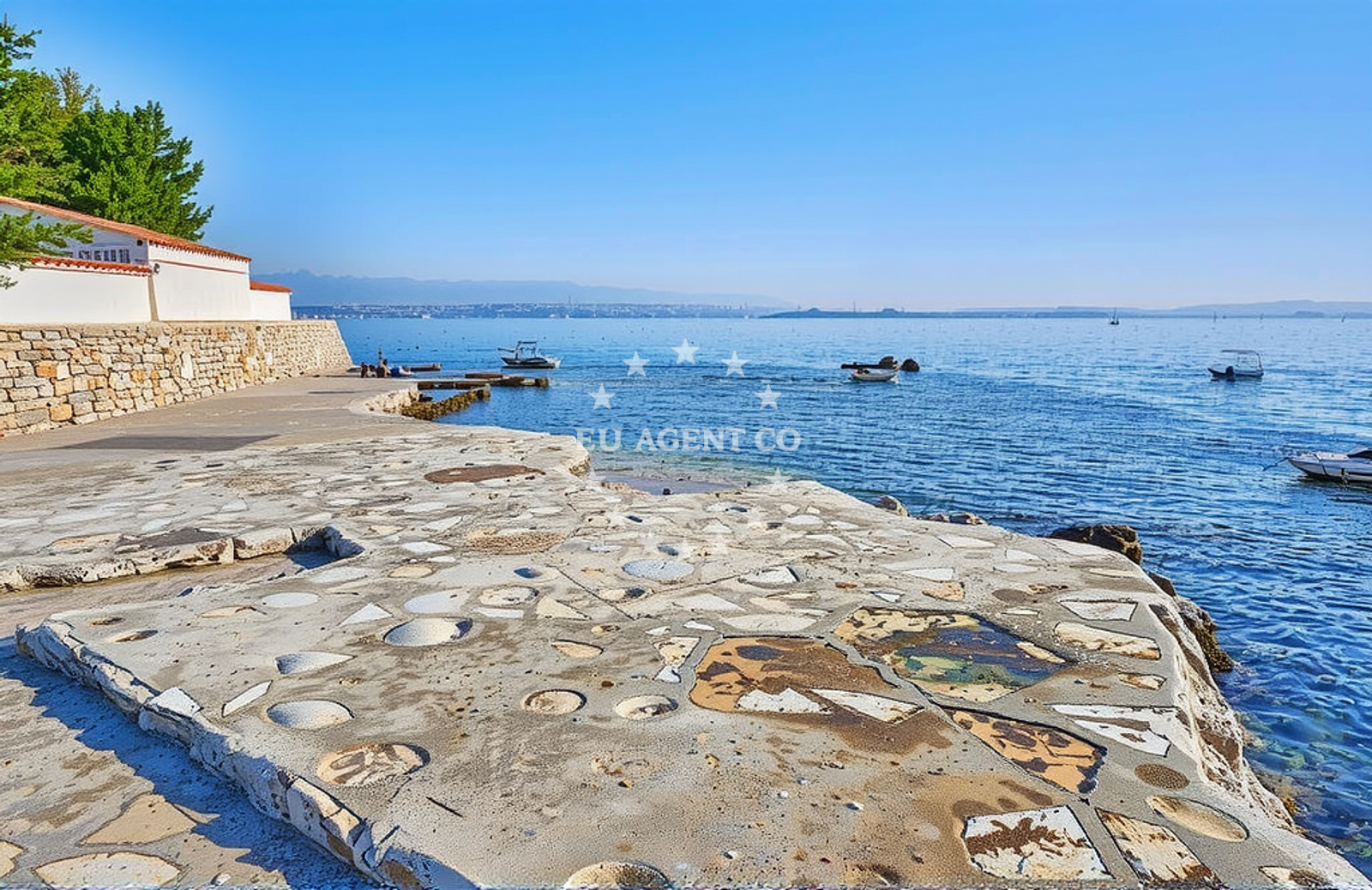
Punta, Poljana (Preko) (Ugljan) Beach lies on the eastern coast of Ugljan, one of the islands in Croatia's Zadar archipelago. This shoreline is defined by its rocky terrain and concrete/stone slabs, offering a more rugged alternative to the region's more developed beaches. Located near the village of Preko, the beach sits within a landscape shaped by the Adriatic's geological history, with limestone formations and coastal cliffs visible in the surrounding area. The beach's proximity to Zadar and the nearby islands of Šolta and Pasman makes it a point of interest for those exploring the Dalmatian coast by boat or land.
About this beach
Punta, Poljana (Preko) (Ugljan)
Beach: Punta
Location: Poljana (Preko) (Ugljan)
Characteristics and facilities
Concrete / stone slabs, rocks
Beach character
The beach's primary feature is its rocky and concrete composition, with slabs and stones forming the shoreline. This terrain suggests limited sandy areas, making it more suitable for those seeking a natural, less conventional beach experience. The lack of structured amenities aligns with the beach's character as a more secluded and rugged stretch of coast. The surrounding area includes coastal cliffs and limestone outcrops, typical of the Zadar archipelago's geology. The beach's orientation faces the open sea, offering views of the mainland and nearby islands, though the rocky nature may limit direct water access for swimmers.
Swimming and shore
Swimming conditions at Punta, Poljana (Preko) (Ugljan) Beach are influenced by the rocky shoreline. The concrete and stone slabs may create uneven entry points into the water, making it less ideal for families with young children. However, the area's natural character could appeal to those seeking a more adventurous coastal experience. The surrounding waters are part of the Adriatic's clear, temperate seas, which are generally suitable for swimming during the summer months. The beach's position within the Zadar archipelago means it is surrounded by navigable waters, with nearby anchorages and marinas accessible by boat.
Facilities and activities
No structured facilities are explicitly listed for this beach, consistent with its natural and undeveloped character. The absence of amenities such as showers, toilets, or parking aligns with the beach's description as a more remote and rugged shoreline. Activities associated with the beach are not specified in the catalog, but the surrounding area offers opportunities for hiking, cycling, and exploring the Zadar archipelago's cultural sites. The beach's location near Preko and Ugljan provides access to local villages, where traditional Croatian cuisine and crafts can be experienced.
Access and location
Access to Punta, Poljana (Preko) (Ugljan) Beach is likely via local roads connecting to the village of Preko on Ugljan. The beach's position on the island places it within reach of Zadar, the nearest major city, which is approximately 15 kilometers northeast. The Zadar archipelago is a popular sailing destination, with marinas in Zadar, Supetar (on the island of Brac), and other nearby ports providing access to the area. The beach's coordinates (44.091909, 15.186802) place it in a region known for its clear waters and historic sites, including the Roman ruins of Zavora and the medieval fortress of Zadar.
What to expect
Visitors to Punta, Poljana (Preko) (Ugljan) Beach should expect a natural, undeveloped shoreline defined by rocky and concrete features. The beach lacks structured amenities, making it more suitable for those seeking a secluded coastal experience. The surrounding area offers opportunities to explore the Zadar archipelago's geological and cultural heritage, with nearby villages and historical sites accessible by land or sea. The beach's position within the Adriatic's sailing region means it is well-connected to yacht charter routes, with nearby marinas and anchorages facilitating access for boaters.
Practical tips
Wear sturdy footwear for navigating the rocky shoreline, and bring a towel or mat for comfort on the concrete slabs. The beach's undeveloped nature means there are no facilities for food or drink, so plan accordingly. For those arriving by boat, nearby marinas in Zadar or Supetar offer docking options. The area's popularity with yacht charter guests suggests that the surrounding waters are well-suited for sailing, with opportunities to explore nearby islands and coastal towns.
Exploring the coast by yacht
The Zadar archipelago, where Punta, Poljana (Preko) (Ugljan) Beach is located, is a key region for yacht charter in Croatia. The area's clear waters, historic sites, and proximity to major ports make it a popular destination for sailors. Yacht charter guests can explore nearby islands such as Šolta, Pasman, and Brac, with marinas in Zadar, Supetar, and other coastal towns providing convenient bases. The beach's position within this sailing region means it is accessible to those exploring the Dalmatian coast by boat, though its natural character may make it more suited to anchoring in nearby bays rather than direct land access.
Historical and Cultural Context
The Zadar archipelago, including Ugljan, has a rich history dating back to ancient Roman times. The nearby town of Zadar is home to the Roman amphitheatre and the medieval fortress, both of which are UNESCO World Heritage sites. The region's cultural heritage is reflected in local traditions, festivals, and cuisine, with dishes such as 'štrukle' (rolled pastries) and 'buzara' (a seafood stew) being regional specialties. Visitors can explore these cultural elements by land or sea, with yacht charter routes offering access to both coastal towns and inland attractions.
Anchorages in the surrounding area
- Anchorage — ugljan — 2.4 NM from beach
- Anchorage — zadar — 2.6 NM from beach
- Anchorage — ugljan — 2.6 NM from beach
- Puntamika — zadar — 2.7 NM from beach
- Anchorage — kali — ugljan — 2.9 NM from beach
- Anchorage — ugljan — 3.3 NM from beach
- Anchorage — ugljan — 3.4 NM from beach
- Anchorage — ceprljanda — ugljan — 3.5 NM from beach
Distances are straight-line geographic distances, not sailing routes.
Mooring buoys in the surrounding area
Mooring buoys in Ošljak and Zadar are located in the surrounding area.
- Ošljak — osljak — 1.3 NM from beach
- Jetty — zadar — 2.5 NM from beach
- Jetty — zadar — 2.5 NM from beach
- Buoy — kali — ugljan — 2.9 NM from beach
- Jetty — iz veli — 4.0 NM from beach
Distances are straight-line geographic distances, not sailing routes.
Marine fuel stations
Fuel stations in Preko and Zadar are situated close to the beach.
- Ina — preko — ugljan — 1.0 NM from beach
- Ina — zadar — 2.4 NM from beach
- Fuel station — sukosan — 5.3 NM from beach
- Ina — zaglav — dugi otok — 8.7 NM from beach
Distances are straight-line geographic distances, not sailing routes.
Harbours in the surrounding area
Harbors in Poljana and adjacent areas are nearby.
- Poljana — ugljan — 0.1 NM from beach
- Sutomišćica — sutomiscica — ugljan — 0.9 NM from beach
- Lukoran — ugljan — 1.6 NM from beach
- Batalaža — kali — ugljan — 2.1 NM from beach
- Batalaža — kali — ugljan — 2.1 NM from beach
- Foša — fosa — zadar — 2.1 NM from beach
Distances are straight-line geographic distances, not sailing routes.
Marinas in the surrounding area
- Marina Preko — ugljan — 0.7 NM from beach
- Olive Island Marina — sutomiscica — ugljan — 0.7 NM from beach
- Marina Zadar — 2.4 NM from beach
- Vitrenjak Zadar — 2.5 NM from beach
- Marina Borik — zadar — 2.5 NM from beach
Distances are straight-line geographic distances, not sailing routes.
Restaurants near the beach
Restaurants in Preko offer nearby dining options.
- Slon — preko — ugljan — 0.2 NM from beach
- Gajo — preko — ugljan — 0.5 NM from beach
- Vrulja — preko — ugljan — 0.6 NM from beach
- Roko Konoba & Grill — preko — ugljan — 0.6 NM from beach
- Taverna Joso — preko — ugljan — 0.7 NM from beach
- Dominik — preko — ugljan — 0.7 NM from beach
- Jardin — preko — ugljan — 0.7 NM from beach
Distances are straight-line geographic distances, not sailing routes.
Navigation guides for the surrounding area
Navigation guides for Marina Maslina and surrounding areas are provided.
- Marina (Marina Maslina) — 0.6 NM from beach
- Lukoran Veli — 1.6 NM from beach
- Kali — 1.8 NM from beach
- Uvala Lamjana Mala — 3.0 NM from beach
- Uvala Lamjana Vela — 3.3 NM from beach
Distances are straight-line geographic distances, not sailing routes.
Yachts from nearby departure bases
Sailing yachts
- Elan Impression 40 (Val) — Ugljan Sutomišćica Olive Island — 0.7 NM from departure base to beach
- Sun Odyssey 349 (ESTRELLA) — Zadar Marina — 2.4 NM from departure base to beach
- Bavaria Cruiser 34 (Lena) — Zadar Marina — 2.4 NM from departure base to beach
Catamarans
- Delta F40-XT (Veronchie) — Zadar Marina — 2.4 NM from departure base to beach
- Bali 4.6 (Jako 2) — Zadar Marina — 2.4 NM from departure base to beach
Motor yachts
- Bluegame BG74 (Kimani) — Zadar Port — 2.3 NM from departure base to beach
Gulets / Cruisers
- Gulet (Dolin) — Zadar Port — 2.3 NM from departure base to beach
Motor boats
- Quicksilver Activ 905 (Galeb) — Ugljan Sutomišćica Olive — 0.7 NM from departure base to beach
- Passport 430 cabin (Tijat) — Zadar Port — 2.3 NM from departure base to beach
- Tempest 650 (CAPELLI) — Zadar Marina — 2.4 NM from departure base to beach
Distances are straight-line geographic distances, not sailing routes.