Požega, Prvić Luka (Prvić) Beach, Croatia
About this beach
Požega, Prvić Luka (Prvić)
Beach: Požega
Location: Prvić Luka (Prvić)
Characteristics and facilities
Concrete / stone slabs
290 m
Beach character
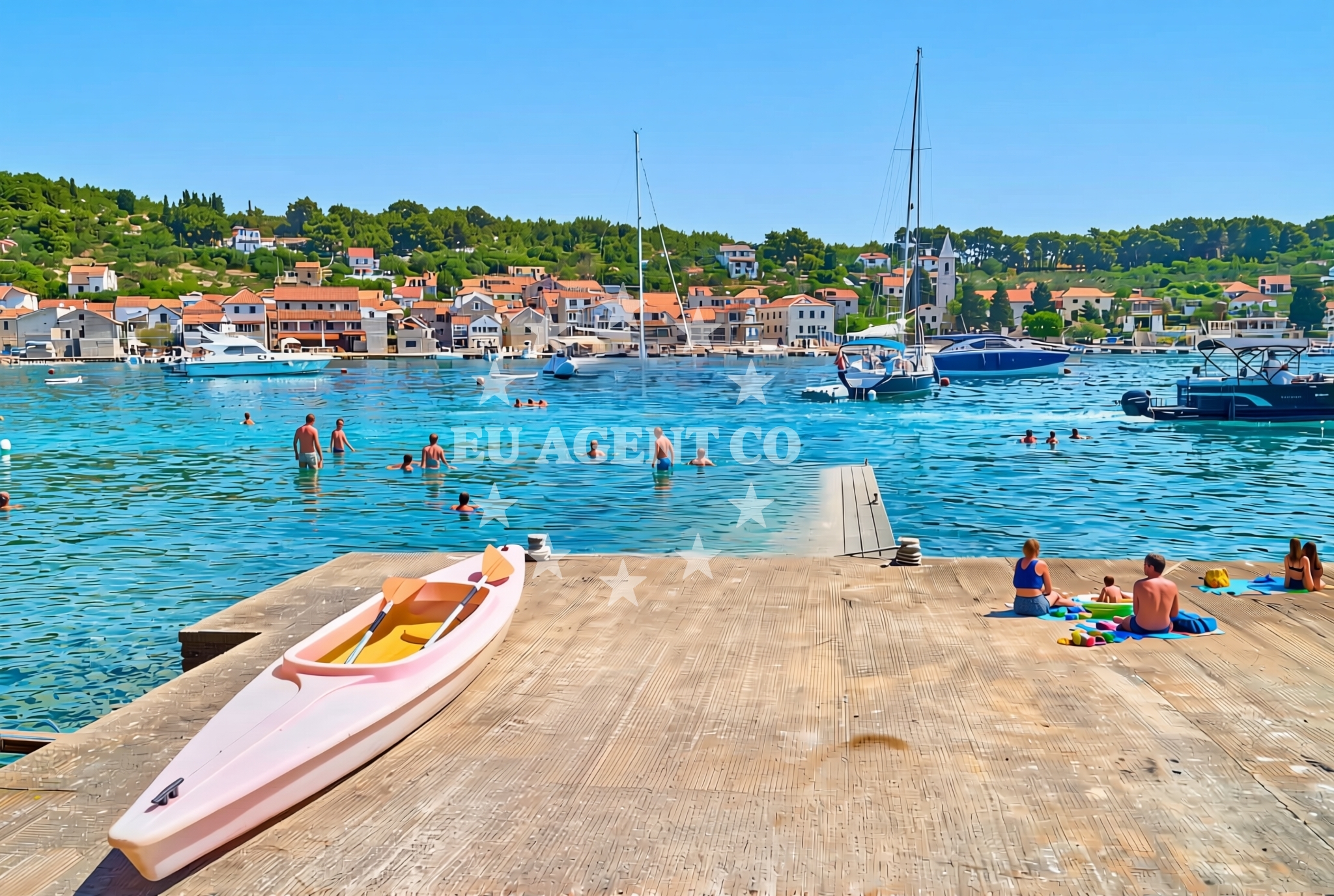
The beach’s defining feature is its composition of concrete and stone slabs, which extend along the shoreline in a linear fashion. This construction suggests a utilitarian purpose, possibly serving as a docking or access point rather than a recreational beach. The absence of sand or natural rock formations means the beach does not offer the typical soft-sand experience, but its flat, stable surface may be suitable for brief stops or as a transitional area between land and sea. The 290-meter length provides enough space for a few individuals to gather, though it does not support large crowds or extended stays.Swimming and shore
Swimming conditions at Požega, Prvić Luka (Prvić) Beach are not explicitly documented in the beach’s authoritative features. The concrete and stone slabs suggest that the immediate shoreline is likely shallow and rocky, which may limit swimming opportunities to the immediate vicinity of the slabs. Beyond this, the Adriatic Sea’s typical characteristics—clear waters and moderate currents—would apply, but visitors should exercise caution when entering the water due to the lack of detailed safety information or marked swimming zones.Facilities and activities
No specific facilities or activities are listed in the beach’s authoritative features. The absence of amenities such as showers, restrooms, or seating suggests that the beach is not designed for extended stays or leisurely relaxation. Its primary function appears to be as an access point or transitional area, possibly for boats or pedestrians moving between the mainland and the island of Prvić. Visitors should not expect services typically found at tourist-oriented beaches.Access and location
Požega, Prvić Luka (Prvić) Beach is located in the town of Požega, on the southern coast of the island of Prvić. The exact coordinates (43.722255, 15.797932) place it near the broader Adriatic coastline, which is known for its maritime activity and sailing routes. Access to the beach likely involves a combination of road and maritime travel, given its position on an island. Visitors arriving by land would need to reach Požega, which is connected to mainland Croatia via ferry services and roads, while those arriving by sea may find the beach useful as a point of reference or temporary landing.What to expect
Visitors to Požega, Prvić Luka (Prvić) Beach should expect a straightforward, utilitarian shoreline composed of concrete and stone slabs. The beach is not designed for leisurely relaxation or recreational activities, but rather serves as a functional access point. Its 290-meter length provides limited space for gathering, and the absence of amenities means visitors should come prepared with their own supplies. The surrounding area, however, offers the broader context of the Adriatic coastline, which is rich in maritime history and sailing opportunities.Practical tips
Given the beach’s utilitarian nature, visitors should plan accordingly. There are no facilities on-site, so bringing water, snacks, and any necessary equipment is advisable. The shoreline’s composition may make it unsuitable for swimming, but it could be a useful spot for brief stops or as a reference point for maritime navigation. Those interested in exploring the area further should consider nearby towns or marinas for additional services.Exploring the coast by yacht
For yacht charter guests, Požega, Prvić Luka (Prvić) Beach lies within a region of the Adriatic known for its sailing routes and coastal exploration opportunities. The nearby island of Prvić and the broader Šibenik-Knin County are popular destinations for motor yachts and sailing boats, offering a mix of open sea, sheltered bays, and historic coastal towns. While the beach itself may not serve as a primary anchorage or marina, its location provides a reference point for those navigating the area. Nearby marinas and anchorages, such as those in Požega or on the mainland, may offer more comprehensive facilities for charter guests.Regional Context and Coastal Exploration
The island of Prvić, where Požega, Prvić Luka (Prvić) Beach is located, is part of a chain of islands that form a natural corridor through the Adriatic. This region is characterized by its rugged coastline, limestone cliffs, and a network of smaller islands that provide sheltered waters for sailing. The area is particularly appealing to yacht charter guests during the summer months, when the sea is calm and the surrounding islands offer opportunities for exploration. Nearby, the town of Požega serves as a hub for maritime activity, with connections to mainland Croatia via ferry routes that link to Split and other major coastal cities.
Anchorages in the surrounding area
Anchorages in the surrounding area include Sepurine and Tijat, offering nearby options for mooring near Prvić Luka.
- Sepurine — prvic sepurine — 0.6 NM from beach
- Anchorage — prvic sepurine — 0.9 NM from beach
- Anchorage — tijat — 1.2 NM from beach
- Anchorage — jadria — 2.2 NM from beach
- Anchorage — zmajan — 2.3 NM from beach
- Anchorage — zmajan — 2.5 NM from beach
- Anchorage — sibenik — 2.6 NM from beach
- Anchorage — zmajan — 2.7 NM from beach
Distances are straight-line geographic distances, not sailing routes.
Mooring buoys in the surrounding area
- Buoy field — prvic — 0.1 NM from beach
- Buoy field — prvic sepurine — 0.6 NM from beach
- Sepurine east — prvic sepurine — 0.9 NM from beach
- Spirito Summer Place jetty — tijat — 1.2 NM from beach
- Buoy field — tijat — 1.2 NM from beach
Distances are straight-line geographic distances, not sailing routes.
Marine fuel stations
Marine fuel stations in Vodice and Sibenik serve the surrounding regions, including central and north Dalmatia.
- Ina — vodice — 2.2 NM from beach
- Petrol — tribunj — 2.8 NM from beach
- Lukoil — sibenik — 4.0 NM from beach
- Ina — sibenik — 4.1 NM from beach
Distances are straight-line geographic distances, not sailing routes.
Harbours in the surrounding area
Harbours such as Prvić Port and Zlarin are situated near the beach, facilitating access to Prvić and周边 areas.
- Konoba Stari Nanini at Prvić Port — prvic — 0.1 NM from beach
- Prvić Šepurine — prvic sepurine — 0.9 NM from beach
- Srima — 1.3 NM from beach
- Zlarin — 2.1 NM from beach
- Jadria — 2.2 NM from beach
- Vodice — 2.2 NM from beach
Distances are straight-line geographic distances, not sailing routes.
Marinas in the surrounding area
- ACI Marina Vodice — 2.3 NM from beach
- Marina Tribunj — 2.9 NM from beach
- Marina Zaton — zaton near sibenik — 3.7 NM from beach
- Amadria Yacht Marines — sibenik — 3.7 NM from beach
- Marina Mandalina — sibenik — 4.4 NM from beach
Distances are straight-line geographic distances, not sailing routes.
Restaurants near the beach
Restaurants in Prvić provide dining options within close proximity to Požega, Prvić Luka Beach.
- Mareta — prvic — 0.1 NM from beach
- Punta — prvic — 0.1 NM from beach
- Konoba Makina — prvic — 0.1 NM from beach
- Val — prvic — 0.2 NM from beach
- Nanini — prvic — 0.2 NM from beach
- Konoba Stari Nanini — prvic — 0.2 NM from beach
- Ribarski Dvor — prvic sepurine — 0.6 NM from beach
Distances are straight-line geographic distances, not sailing routes.
Navigation guides for the surrounding area
Navigation guides for Zlarin and Vodice assist with route planning in the central and north Dalmatia areas near the beach.
- Luka Zlarin — 2.1 NM from beach
- Vodice — 2.2 NM from beach
- Tučepi — 2.7 NM from beach
- Tribunj — 2.9 NM from beach
- Uvala Sovlje — 3.7 NM from beach
Distances are straight-line geographic distances, not sailing routes.
Yachts from nearby departure bases
Yachts departing from Vodice Port and ACI Marina cater to travelers exploring the surrounding regions of Prvić Luka.
Sailing yachts
- Elan Impression 45 (Mirakul) — Vodice ACI Marina — 2.3 NM from departure base to beach
- Dufour 412 Grand large (THEMISTO) — Vodice ACI Marina — 2.3 NM from departure base to beach
Motor boats
- Axopar 37 Sun Top (Axe) — Vodice port — 2.2 NM from departure base to beach
- Salpa Soleil 26 (Podgora) — Vodice Port — 2.2 NM from departure base to beach
- Salpa Soleil 18 (Salpa) — Vodice Port — 2.2 NM from departure base to beach
- Salpa Soleil 20 (Salpa) — Vodice Port — 2.2 NM from departure base to beach
- Salpa Soleil 24.5 (Zaostrog) — Vodice Port — 2.2 NM from departure base to beach
- Marlin 790 Dynamic (Marlin) — Vodice Port — 2.2 NM from departure base to beach
- Merry Fisher 795 (Brac) — Vodice Port — 2.2 NM from departure base to beach
- Salpa Sunsix (Ika) — Vodice Port — 2.2 NM from departure base to beach
Distances are straight-line geographic distances, not sailing routes.