Paklena sredina, Vrboska (Hvar) Beach, Croatia
8 photos
About this beach
Paklena sredina, Vrboska (Hvar)
Beach: Paklena sredina
Location: Vrboska (Hvar)
Characteristics and facilities
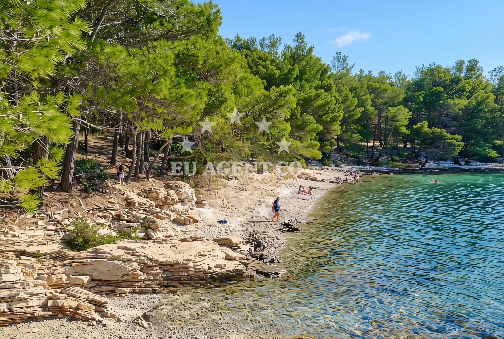
Gravel, rocks
Natural shade
Beach character
The beach’s composition of gravel and rocks creates a distinctive texture underfoot, ideal for those seeking a more rugged coastal experience. Natural shade is available from clusters of vegetation along the shoreline, offering respite from the sun without the need for artificial structures. While the beach lacks formal amenities, its unspoiled character appeals to visitors looking to escape crowded resorts and enjoy a more authentic slice of the Adriatic coast.Swimming and shore
Swimming conditions at Paklena sredina depend on the season and wave activity, with the gravelly seabed providing a stable surface for wading. The shore’s rocky terrain means access to the water may require careful navigation, particularly during high tide. The beach’s location on Hvar’s southern coast places it within reach of the broader Adriatic sailing routes, where clear waters and sheltered coves are common features.Facilities and activities
No formal facilities are listed for Paklena sredina Beach, reflecting its status as a more remote and natural shoreline. Activities are limited to passive enjoyment of the landscape, though the proximity to Vrboska offers opportunities to explore local culture, dining, and historic sites. The beach itself is best suited for solitary relaxation or short walks along the coast.Access and location
Paklena sredina is accessible via local roads connecting to Vrboska, a village on Hvar’s western coast. Vrboska itself is a hub for traditional Croatian architecture, with narrow streets lined by stone buildings and a harbor that hosts both fishing boats and charter yachts. The beach’s location on Hvar’s southern shore places it within sailing distance of other notable Adriatic destinations, including the islands of Brac and Korcula.What to expect
Visitors should expect a rugged, unspoiled shoreline with gravel and rocks forming the beach’s surface. Natural shade is available from coastal vegetation, though there are no formal amenities such as showers, restrooms, or parking. The beach’s remote character makes it an ideal spot for those seeking solitude, though its proximity to Vrboska means access to local services and cultural attractions is within reach.Practical tips
Wear sturdy footwear to navigate the gravel and rocky terrain comfortably. Sunscreen and a hat are recommended, as natural shade is limited to vegetation. Consider visiting during off-peak hours to avoid crowds, and explore nearby Vrboska for dining and cultural experiences.Exploring the coast by yacht
For yacht charter guests, the broader Hvar region offers a compelling sailing itinerary. The island’s coastline features a mix of sheltered bays and open waters, with marinas in Vrboska and Hvar Town providing convenient bases. While Paklena sredina itself is not a docking point, the surrounding area is part of a network of anchorages and ports that cater to both motor and sailing yachts exploring the Adriatic.Cultural and Historical Context
Vrboska, the village near Paklena sredina, is one of Hvar’s oldest settlements, with records dating back to the 13th century. Its historic core features a 16th-century fortress and a vibrant weekly market. The island’s connection to maritime history is evident in its many harbors and the presence of modern yacht marinas, reflecting Hvar’s enduring relationship with the sea.Anchorages in the surrounding area
- Anchorage — vrboska — hvar — 0.2 NM from beach
- Anchorage — hvar — 0.6 NM from beach
- Anchorage — vrboska — hvar — 1.1 NM from beach
- Uvala Basina — vrbanj — hvar — 1.8 NM from beach
- Anchorage — hvar — 2.6 NM from beach
- Anchorage — hvar — 2.7 NM from beach
- Anchorage — hvar — 2.7 NM from beach
- Anchorage — hvar — 2.9 NM from beach
Distances are straight-line geographic distances, not sailing routes.
Mooring buoys in the surrounding area
- Quay — hvar — 0.6 NM from beach
- Jetty — vrbanj — hvar — 1.9 NM from beach
- Jetty — vrbanj — hvar — 1.9 NM from beach
- Jetty — zavala — hvar — 3.4 NM from beach
- Buoy field — stari grad — hvar — 4.4 NM from beach
Distances are straight-line geographic distances, not sailing routes.
Marine fuel stations
- Ina — vrboska — hvar — 0.9 NM from beach
- Fuel station — bol — brac — 5.1 NM from beach
- Fuel station — sumartin — brac — 9.8 NM from beach
- Fuel station — hvar — 11.0 NM from beach
Distances are straight-line geographic distances, not sailing routes.
Harbours in the surrounding area
- Vrboska — hvar — 0.9 NM from beach
- Port Jelsa — hvar — 1.0 NM from beach
- Stari Grad — hvar — 4.5 NM from beach
- Bol — brac — 5.2 NM from beach
- Marina Bilo Idro — sveta nedjelja — hvar — 5.5 NM from beach
- Sumartin — brac — 10.0 NM from beach
Distances are straight-line geographic distances, not sailing routes.
Marinas in the surrounding area
- ACI Marina Vrboska — hvar — 0.8 NM from beach
- ACI Marina Palmižana — aci marina palmizana — st klement — 13.2 NM from beach
- Marina Korkyra — vela luka — korcula — 13.2 NM from beach
- ACI Marina Milna — milna brac — 13.9 NM from beach
- Marina Milna Kanarija — milna brac — 14.1 NM from beach
Distances are straight-line geographic distances, not sailing routes.
Restaurants near the beach
- Restoran Luka — vrboska — hvar — 0.8 NM from beach
- Bonaca — vrboska — hvar — 0.8 NM from beach
- Trica Gardelin — vrboska — hvar — 1.0 NM from beach
- Me and Mrs Jones — jelsa — hvar — 1.0 NM from beach
- Arsenal — jelsa — hvar — 1.0 NM from beach
- Konoba Lem — vrboska — hvar — 1.0 NM from beach
- Restaurant Pizzeria Skojic — vrboska — hvar — 1.0 NM from beach
Distances are straight-line geographic distances, not sailing routes.
Navigation guides for the surrounding area
- Vrboska — 0.5 NM from beach
- Otocic Zecevo — 0.7 NM from beach
- Jelsa — 1.0 NM from beach
- Uvala Basina — 1.5 NM from beach
- Zavala (Pitavska Plaza) — 3.5 NM from beach
Distances are straight-line geographic distances, not sailing routes.
Yachts from nearby departure bases
Sailing yachts
- Hanse 388 (BANJO) — Milna Marina Vlaška — 14.3 NM from departure base to beach
- Bavaria 46 Cruiser (MO) — Milna Marina Vlaška — 14.3 NM from departure base to beach
- Hanse 455 (AURUM 1) — Milna Marina Vlaška — 14.3 NM from departure base to beach
- Hanse 505 (AVALON) — Milna Marina Vlaška — 14.3 NM from departure base to beach
- Elan Impression 40 (KARLETA) — Baška Voda Port — 15.4 NM from departure base to beach
- Oceanis 45 (FORTUNE) — Baška Voda — 15.4 NM from departure base to beach
- Hanse 445 (HELIOS) — Baška Voda — 15.4 NM from departure base to beach
Catamarans
- Lagoon 450 (LAMANTIN) — Baška Voda — 15.4 NM from departure base to beach
Motor yachts
- Canados 86 (Karisma) — Baška Voda — 15.4 NM from departure base to beach
Motor boats
- Pearl Sea 31 Hard Top (Aero) — Baška Voda Port — 15.4 NM from departure base to beach
Distances are straight-line geographic distances, not sailing routes.
Frequently asked questions
Is Paklena sredina Beach suitable for families with young children?
The beach’s gravel and rocky terrain may pose challenges for young children, making it less ideal for families with very young kids. However, the natural shade and proximity to Vrboska offer opportunities for a more varied visit.Are there parking facilities near the beach?
No specific parking facilities are listed for Paklena sredina Beach. Visitors are advised to check local road access and consider parking in nearby Vrboska.Nearby beaches
Paklena zapad, Vrboska (Hvar) Beach
Paklena zapad
0.1 km
Paklena beach
Jelsa 1015B , Jelsa
0.1 km
Glavica, Vrboska (Hvar) Beach
Glavica
0.2 km
Balun, Vrboska (Hvar) Beach
Balun
0.3 km
Soline beach
Vrboska 184, Vrboska
0.4 km
Adriatic, Vrboska (Hvar) Beach
Adriatic
0.5 km
Plaza Kamenjara
Vrboska 184, Vrboska
0.5 km
Križ, Vrboska (Hvar) Beach
Križ
0.7 km