Oskorušica, Vrbanj (Hvar) Beach, Croatia
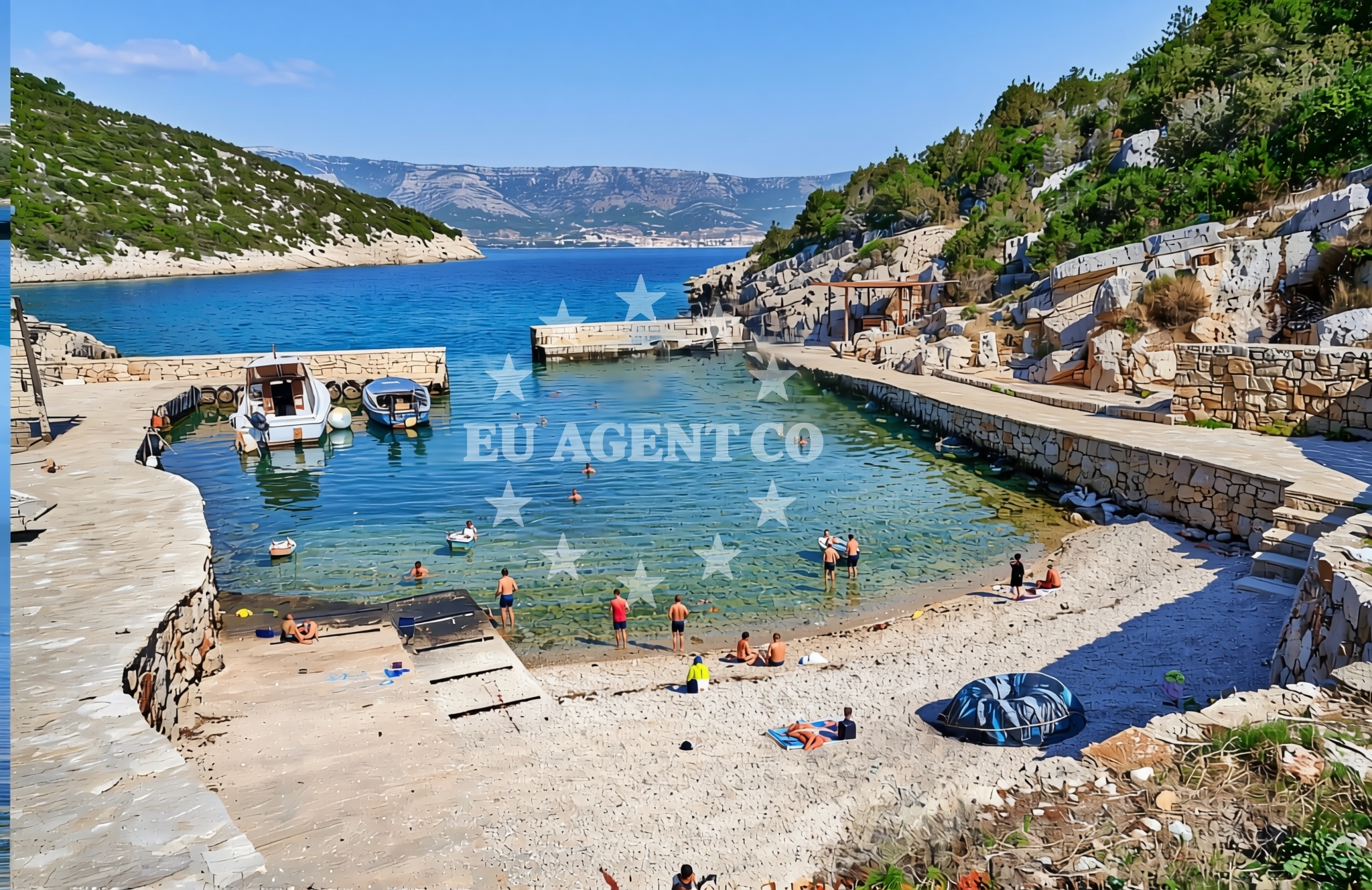
Oskorušica Beach is a coastal stretch located in Vrbanj, a village on the island of Hvar in Croatia’s Adriatic Sea. Part of the broader Hvar archipelago, this beach features a shoreline composed of gravel and concrete/stone slabs, offering a distinct contrast to the island’s more sandy or pebbly shores. While no formal amenities are listed for the beach itself, its position on Hvar—a destination renowned for its medieval towns, vineyards, and sailing opportunities—positions it as a potential stop for those exploring the island’s coastline by foot, bike, or boat.
About this beach
Oskorušica, Vrbanj (Hvar)
Beach: Oskorušica
Location: Vrbanj (Hvar)
Characteristics and facilities
Gravel, concrete / stone slabs
Beach character
The beach’s surface is defined by gravel and concrete/stone slabs, a characteristic that may appeal to visitors seeking a more rugged or utilitarian shoreline. This type of beach is less common on Hvar, where many coastal areas feature white sand or pebbles. The lack of detailed natural features in the catalog suggests the beach may not be a primary swimming spot, though its proximity to Hvar’s well-established tourism infrastructure could make it a secondary option for those staying in the village of Vrbanj or nearby areas.
Swimming and shore
No specific details about swimming conditions or water depth are provided in the catalog. The gravel and stone slab shoreline may make it less ideal for young children or those seeking a traditional sandy beach experience. However, the beach’s location on Hvar—a region known for clear waters and mild Mediterranean temperatures—could still make it a viable option for swimmers, particularly during the summer months when sea conditions are typically calm.
Facilities and activities
The catalog does not list any formal facilities such as showers, toilets, or parking areas at Oskorušica Beach. This absence of structured amenities aligns with the beach’s description as a more modest or utilitarian shoreline. Visitors should assume that basic infrastructure may be limited, though nearby Vrbanj—like much of Hvar—offers hotels, restaurants, and other services that could serve as alternatives for those needing facilities not available directly at the beach.
Access and location
Located in Vrbanj, a village on the island of Hvar, Oskorušica Beach is part of a region that is easily accessible by sea or land. Hvar itself is a popular destination for both land-based tourism and sailing, with the island’s main town of Hvar (also called Hvar Town) situated just a few kilometers away. Visitors arriving by car can reach Vrbanj via the island’s road network, while those arriving by boat may find nearby marinas in Hvar Town or the port of Jelsa useful as starting points for exploring the coastline.
What to expect
Visitors to Oskorušica Beach should expect a shoreline defined by gravel and concrete/stone slabs, a feature that may make it less conventional compared to Hvar’s more typical sandy or pebbly beaches. While no formal facilities are listed for the beach itself, the surrounding area of Vrbanj offers accommodations, dining, and other services. The beach’s position on Hvar—a destination known for its cultural heritage, vineyards, and sailing opportunities—suggests it may be more appealing to those seeking a quiet, less commercialized stretch of coastline rather than a primary tourist spot.
Practical tips
Given the beach’s gravel and stone slab shoreline, visitors with young children or those preferring softer sands may wish to explore other beaches in Vrbanj or nearby areas. The absence of detailed facilities in the catalog means it is advisable to check nearby options in Vrbanj for amenities such as parking, restrooms, or refreshments.
Exploring the coast by yacht
For those exploring the Adriatic by yacht, Oskorušica Beach’s location on Hvar offers a strategic vantage point. The island is a hub for sailing, with marinas in Hvar Town and Jelsa serving as common bases for charter boats. While the beach itself may not be a primary anchorage, its proximity to these marinas and the broader Hvar coastline makes it a potential stop for sailors seeking to combine land and sea exploration. The surrounding waters are known for their clarity and gentle currents, making them suitable for both leisurely cruising and more active sailing.
Hvar’s Coastal Appeal
The island of Hvar, where Oskorušica Beach is located, is celebrated for its natural beauty, historic sites, and vibrant maritime culture. Beyond its beaches, the island is home to the medieval town of Hvar, the saltworks of Stari Grad, and the famous Hvar Vineyards. For yacht charter guests, the area offers a mix of sheltered bays, open sea routes, and cultural landmarks, making it a year-round destination for sailors and tourists alike.
Anchorages in the surrounding area
Anchorages in Hvar, including Uvala Basina near Vrbanj.
- Anchorage — hvar — 0.2 NM from beach
- Anchorage — hvar — 0.4 NM from beach
- Anchorage — hvar — 0.6 NM from beach
- Anchorage — hvar — 0.9 NM from beach
- Uvala Basina — vrbanj — hvar — 1.1 NM from beach
- Anchorage — hvar — 1.3 NM from beach
- Anchorage — vrboska — hvar — 1.8 NM from beach
- Anchorage — hvar — 2.5 NM from beach
Distances are straight-line geographic distances, not sailing routes.
Mooring buoys in the surrounding area
Mooring buoys in Vrbanj and Hvar, plus a buoy field in Bol, Brac.
- Jetty — vrbanj — hvar — 1.0 NM from beach
- Jetty — vrbanj — hvar — 1.0 NM from beach
- Quay — hvar — 2.5 NM from beach
- Buoy field — stari grad — hvar — 2.7 NM from beach
- Buoy field — bol — brac — 2.8 NM from beach
Distances are straight-line geographic distances, not sailing routes.
Marine fuel stations
Fuel stations in Vrboska, Bol, Brac, and Sumartin, Brac.
- Ina — vrboska — hvar — 2.3 NM from beach
- Fuel station — bol — brac — 2.9 NM from beach
- Fuel station — hvar — 9.2 NM from beach
- Fuel station — sumartin — brac — 10.5 NM from beach
Distances are straight-line geographic distances, not sailing routes.
Harbours in the surrounding area
Harbors in Vrboska, Stari Grad, Bol, Brac, Port Jelsa, and Pučišća.
- Vrboska — hvar — 2.2 NM from beach
- Stari Grad — hvar — 2.8 NM from beach
- Bol — brac — 3.0 NM from beach
- Port Jelsa — hvar — 3.7 NM from beach
- Marina Bilo Idro — sveta nedjelja — hvar — 5.3 NM from beach
- Pučišća harbour — pucisca — brac — 9.1 NM from beach
Distances are straight-line geographic distances, not sailing routes.
Marinas in the surrounding area
Marinas in Vrboska and Milna, Brac, including ACI Marina Vrboska and Marina Milna Kanarija.
- ACI Marina Vrboska — hvar — 2.4 NM from beach
- ACI Marina Milna — milna brac — 11.0 NM from beach
- Marina Milna Kanarija — milna brac — 11.2 NM from beach
- ACI Marina Palmižana — aci marina palmizana — st klement — 11.4 NM from beach
- Marina Vlaška — milna brac — 11.4 NM from beach
Distances are straight-line geographic distances, not sailing routes.
Restaurants near the beach
Restaurants in Vrboska, including Tavern Lavcevic and Restaurant Pizzeria Skojic, plus options in Stari Grad.
- Tavern Lavcevic — vrboska — hvar — 2.1 NM from beach
- Konoba Lem — vrboska — hvar — 2.1 NM from beach
- Restaurant Pizzeria Skojic — vrboska — hvar — 2.2 NM from beach
- Trica Gardelin — vrboska — hvar — 2.2 NM from beach
- Bonaca — vrboska — hvar — 2.4 NM from beach
- Restoran Luka — vrboska — hvar — 2.4 NM from beach
- Restaurant — stari grad — hvar — 2.5 NM from beach
Distances are straight-line geographic distances, not sailing routes.
Navigation guides for the surrounding area
Navigation guides for Uvala Basina, Luka Vlaska, Vrboska, Otocic Zecevo, and Luka Zavala.
- Uvala Basina — 1.4 NM from beach
- Luka Vlaska — 2.5 NM from beach
- Vrboska — 2.5 NM from beach
- Otocic Zecevo — 2.7 NM from beach
- Luka Zavala — 3.1 NM from beach
Distances are straight-line geographic distances, not sailing routes.
Yachts from nearby departure bases
Yachts from Milna Marina Vlaška, including sail boats and gulets, and catamarans from Sumpetar Port.
Sailing yachts
- Hanse 455 (AURUM 1) — Milna Marina Vlaška — 11.4 NM from departure base to beach
- Hanse 388 (BANJO) — Milna Marina Vlaška — 11.4 NM from departure base to beach
- Hanse 505 (AVALON) — Milna Marina Vlaška — 11.4 NM from departure base to beach
- Bavaria 46 Cruiser (MO) — Milna Marina Vlaška — 11.4 NM from departure base to beach
Catamarans
- Lagoon 450 Fly (Falco) — Sumpetar Port — 14.4 NM from departure base to beach
Gulets / Cruisers
- Gulet (Trebenna) — Omiš City Port — 14.0 NM from departure base to beach
- Gulet (Primorac) — Omiš City Port — 14.0 NM from departure base to beach
- Gulet (PATRONICE) — Omiš City Port — 14.1 NM from departure base to beach
- Gulet (Cataleya) — Sumpetar Port — 14.4 NM from departure base to beach
- Gulet (Altair) — Sumpetar Port — 14.4 NM from departure base to beach
Distances are straight-line geographic distances, not sailing routes.