Mala Garška Beach, Hvar, Croatia
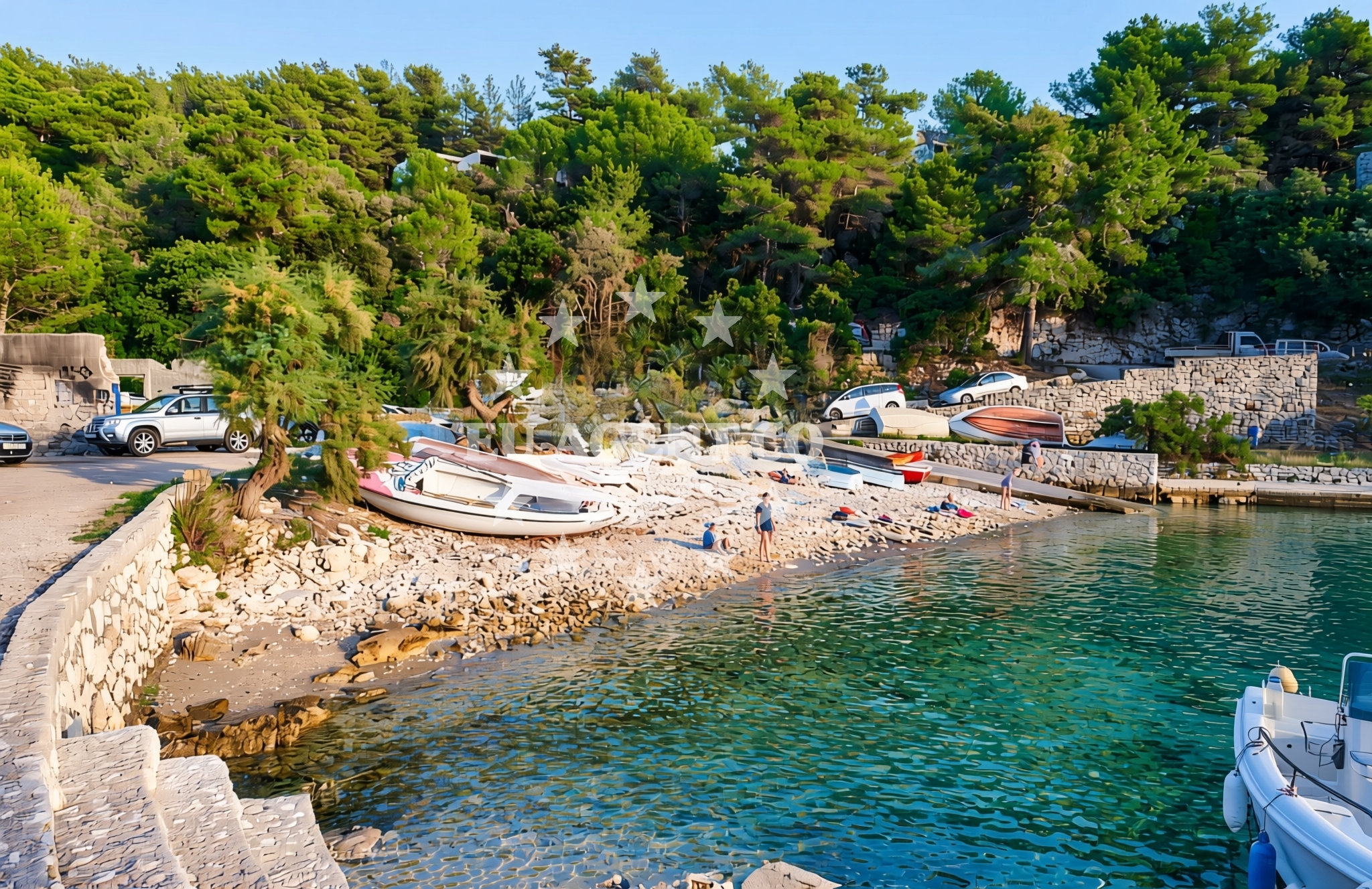
Mala Garška Beach is a distinctive shoreline on the island of Hvar, located in the Adriatic Sea. Unlike the typical sandy beaches of the Dalmatian coast, this beach is characterized by gravel and concrete/stone slabs, offering a unique texture for visitors to explore. Its proximity to Hvar Town, a historic and vibrant settlement, makes it a convenient stop for those exploring the island’s cultural and natural attractions.
About this beach
Mala Garška, Hvar (Hvar)
Beach: Mala Garška
Location: Hvar (Hvar)
Characteristics and facilities
Gravel, concrete / stone slabs
Beach character
The beach’s surface is composed of gravel and stone slabs, creating a firm and uneven terrain. This contrasts sharply with the soft sands of other Hvar beaches, making it an unusual but intriguing spot for visitors. The lack of traditional beach amenities means the focus is on the raw, natural character of the coastline. The surrounding area is likely to be rocky, with limited vegetation, typical of the island’s rugged southern shore.
Swimming and shore
While the beach’s gravelly composition may not be ideal for swimming, the nearby waters of the Adriatic Sea are known for their clarity and moderate currents. The shore is likely to be exposed to the elements, with minimal shelter from waves. This makes it more suitable for short dips or wading rather than extended swimming sessions. The rocky terrain may offer vantage points for observing marine life or enjoying the open sea views.
Facilities and activities
There are no formal facilities listed for Mala Garška Beach, such as showers, toilets, or umbrellas. Visitors should expect a minimalistic setting, with no structured amenities. The beach’s natural character may appeal to those seeking a secluded or unconventional coastal experience. Activities here are likely limited to walking along the shore, sunbathing on the stone slabs, or exploring the nearby rocky coastline.
Access and location
Mala Garška Beach is situated on the southern coast of Hvar Island, a region known for its dramatic cliffs and historic sites. The nearest major settlement is Hvar Town, located approximately 6 kilometers to the northwest. Access to the beach is likely via local roads or footpaths, given its remote character. The area is part of the broader Hvar archipelago, which is a popular destination for yacht charters and sailing excursions along the Croatian coast.
What to expect
Visitors to Mala Garška Beach should anticipate a rugged, gravelly shoreline with concrete and stone slabs. The beach is not suited for traditional sunbathing or swimming but offers a unique opportunity to engage with the natural landscape of Hvar’s southern coast. The area’s proximity to Hvar Town provides access to cultural and culinary experiences, though the beach itself remains a quiet, unspoiled spot. The surrounding waters are part of the Adriatic’s renowned sailing routes, making it a potential waypoint for yacht charter guests exploring the region.
Practical tips
Given the beach’s gravelly terrain, visitors may want to wear sturdy footwear for comfort. Sun protection is essential, as the lack of natural shade means exposure to the sun can be intense. The beach’s remote location suggests limited parking or vehicle access, so arriving by foot or local transport is advisable. Those interested in yacht charters may find nearby anchorages or marinas in Hvar Town useful for planning their itinerary.
Exploring the coast by yacht
The waters surrounding Hvar, including the area near Mala Garška Beach, are a focal point for yacht charter activity in the Adriatic. The island’s coastline offers a mix of sheltered bays and open sea, catering to both leisurely cruising and more adventurous sailing. Yacht charter guests may find the proximity to Hvar Town advantageous, as it provides access to amenities, restaurants, and cultural sites. The beach’s location could serve as a convenient stop for those exploring the southern part of the island or venturing further into the Dalmatian coast.
Historical and Cultural Context of Hvar
Hvar Island has a rich history dating back to ancient times, with influences from the Greeks, Romans, and Venetians. The island is renowned for its lavender fields, vineyards, and historic sites such as the Hvar Fortress and the Church of St. Stephen. Visitors to Mala Garška Beach may find it rewarding to explore these cultural landmarks in Hvar Town, which is a short distance away.
Anchorages in the surrounding area
Anchorages in the surrounding area, including those near Hvar and Marinkovac.
- Anchorage — hvar — 0.1 NM from beach
- Anchorage — hvar — 0.7 NM from beach
- Anchorage — hvar — 0.7 NM from beach
- Anchorage — hvar — 0.8 NM from beach
- Anchorage — hvar — 0.9 NM from beach
- Ždrilca Bay — zdrilca bay — marinkovac — 1.1 NM from beach
- Stipanska — marinkovac — 1.2 NM from beach
- Ždrilca Bay — zdrilca bay — marinkovac — 1.3 NM from beach
Distances are straight-line geographic distances, not sailing routes.
Mooring buoys in the surrounding area
Mooring buoys in the surrounding area, such as those in Hvar and Vira.
- Jetty — hvar — 0.3 NM from beach
- Quay — hvar — 0.7 NM from beach
- Single Buoys Hvar — 0.8 NM from beach
- Buoy field — hvar — 0.8 NM from beach
- Konoba Arsenol Buoy field — vira — hvar — 0.9 NM from beach
Distances are straight-line geographic distances, not sailing routes.
Marine fuel stations
Marine fuel stations located in Hvar and nearby areas like Brac.
- Fuel station — hvar — 1.1 NM from beach
- Ina — milna brac — 8.9 NM from beach
- Ina — vrboska — hvar — 10.9 NM from beach
- Fuel station — bol — brac — 11.2 NM from beach
Distances are straight-line geographic distances, not sailing routes.
Harbours in the surrounding area
Harbours in the surrounding area, including Vira and Hvar.
- Vira — hvar — 0.7 NM from beach
- Hvar — 0.8 NM from beach
- Stari Grad — hvar — 7.3 NM from beach
- Marina Bilo Idro — sveta nedjelja — hvar — 7.6 NM from beach
- Milna — milna brac — 9.0 NM from beach
- Bobovišće — bobovisce — brac — 10.4 NM from beach
Distances are straight-line geographic distances, not sailing routes.
Marinas in the surrounding area
Marinas in the surrounding area, such as ACI Marina Palmižana and those in Brac.
- ACI Marina Palmižana — aci marina palmizana — st klement — 1.7 NM from beach
- ACI Marina Milna — milna brac — 8.9 NM from beach
- Marina Milna Kanarija — milna brac — 8.9 NM from beach
- Marina Vlaška — milna brac — 9.1 NM from beach
- ACI Marina Vrboska — hvar — 11.0 NM from beach
Distances are straight-line geographic distances, not sailing routes.
Restaurants near the beach
Restaurants near the beach, including Panorama in Vira and dining options in Hvar.
- Panorama — vira — hvar — 0.4 NM from beach
- Restaurant — hvar — 0.8 NM from beach
- Dva Ribara — hvar — 0.8 NM from beach
- Restaurant — hvar — 0.8 NM from beach
- Dalmatino — hvar — 0.8 NM from beach
- Ringo — vira — hvar — 0.8 NM from beach
- Konoba Arsenol — vira — hvar — 0.8 NM from beach
Distances are straight-line geographic distances, not sailing routes.
Navigation guides for the surrounding area
Navigation guides for the surrounding area, including Luka Mala Garska and nearby bays.
- Luka Mala Garska — 0.2 NM from beach
- Uvala Vira (Uvala Pribinja) — 1.0 NM from beach
- Uvala Vinogradisce — 1.9 NM from beach
- Uvala Duboka Vela — 1.9 NM from beach
- Uvala Stari Stani — 2.2 NM from beach
Distances are straight-line geographic distances, not sailing routes.
Yachts from nearby departure bases
Yachts from nearby departure bases such as Milna Marina Vlaška and Šolta Rogač.
Sailing yachts
- Hanse 388 (BANJO) — Milna Marina Vlaška — 9.1 NM from departure base to beach
- Bavaria 46 Cruiser (MO) — Milna Marina Vlaška — 9.1 NM from departure base to beach
- Hanse 505 (AVALON) — Milna Marina Vlaška — 9.1 NM from departure base to beach
- Hanse 455 (AURUM 1) — Milna Marina Vlaška — 9.1 NM from departure base to beach
- Cyclades 39.3 (Alaska) — Šolta Rogač — 14.1 NM from departure base to beach
- Sun Odyssey 449 (Tortuga) — Šolta Rogač — 14.1 NM from departure base to beach
- Oceanis 46.1 (Everest) — Šolta Rogač — 14.1 NM from departure base to beach
Catamarans
- Lagoon 40 (Solentia) — Šolta Rogač — 14.1 NM from departure base to beach
- Lagoon 42 (Galapagos) — Šolta Rogač — 14.1 NM from departure base to beach
- Lagoon 450 Flybridge (Samogon) — Šolta Rogač — 14.1 NM from departure base to beach
Distances are straight-line geographic distances, not sailing routes.