Luka stonska sredina, Luka (Ston) Beach, Croatia
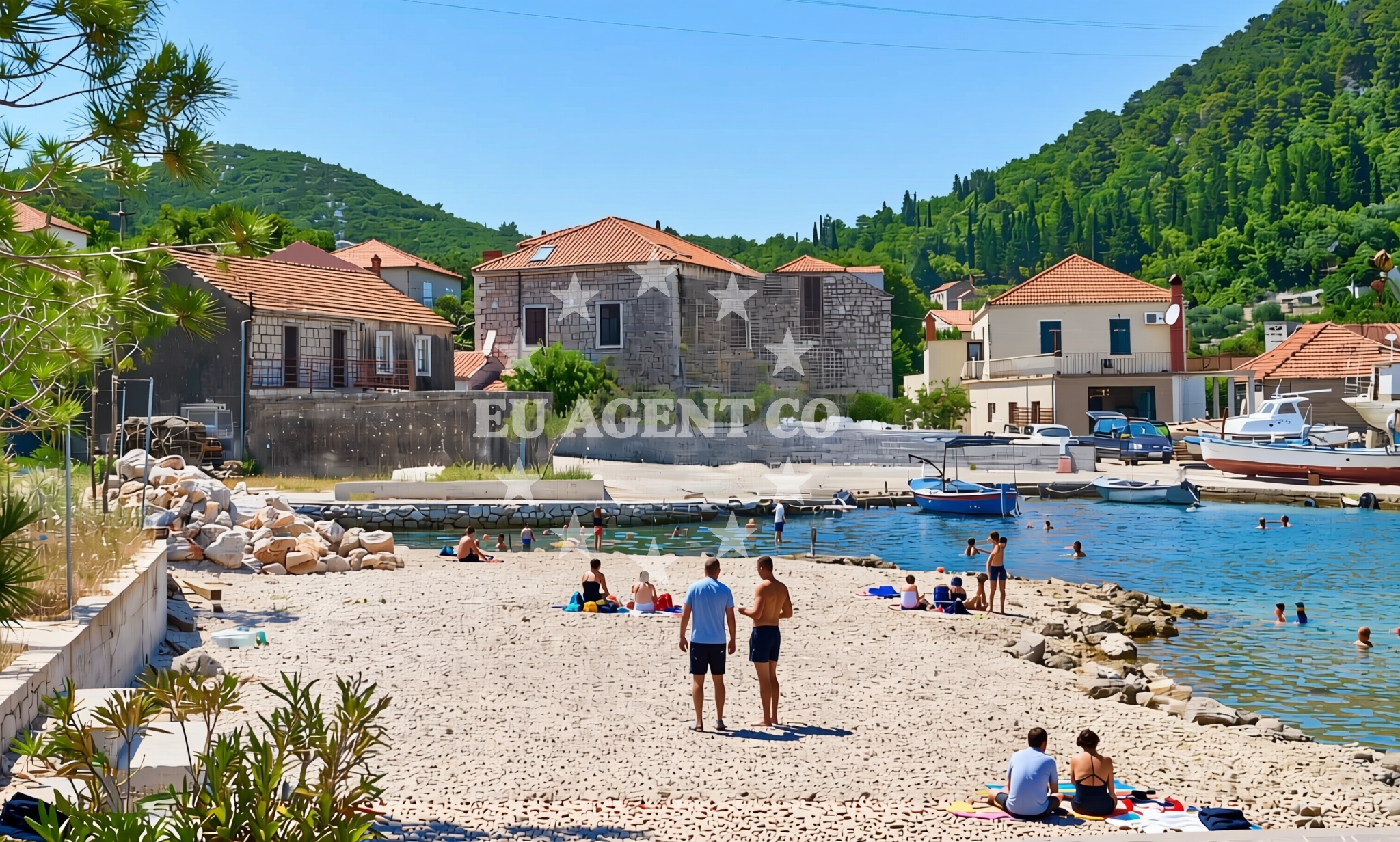
About this beach
Luka stonska sredina, Luka (Ston)
Beach: Luka stonska sredina
Location: Luka (Ston)
Characteristics and facilities
Gravel
40 m
Beach character
The beach is characterized by its gravel composition, which gives it a rugged and uneven texture. This type of shoreline is less common in the area and may appeal to visitors interested in a more natural, unaltered coastal environment. The beach's short length means it is best suited for brief visits or as a stopover during a broader exploration of the region.Swimming and shore
Due to its gravelly composition, Luka stonska sredina is not a typical swimming beach. The shoreline is uneven and lacks the smooth, sandy conditions that are more common in the area. However, the beach's proximity to the sea allows for views of the Adriatic and provides a setting for activities such as photography or simply walking along the shore.Facilities and activities
No specific facilities or amenities are listed for Luka stonska sredina. The beach appears to be a natural, undeveloped stretch of coastline with no marked recreational infrastructure. Visitors should expect a minimalistic setting, focusing on the raw coastal environment rather than structured amenities.Access and location
Luka stonska sredina is situated in Luka (Ston), a coastal town on the Pelješac Peninsula in Croatia. The beach is located near the town's harbor, which is a key point for maritime activity in the region. Its position along the Adriatic coast places it within reach of several sailing routes and nearby settlements, including the historic town of Ston and the broader Dubrovnik area.What to expect
Visitors to Luka stonska sredina should prepare for a beach experience that is distinctly different from the region's more conventional sandy shores. The gravelly terrain may make walking uncomfortable in bare feet, and the beach's short length means there is limited space for extended stays. However, the location offers opportunities to observe the surrounding maritime landscape and enjoy the natural character of the coastline.Practical tips
Wear sturdy footwear to navigate the gravel terrain comfortably. The beach's proximity to the harbor may make it a convenient stop for those exploring the area by boat or yacht. Due to its undeveloped nature, there are no facilities for food, drink, or shade, so visitors should bring their own supplies.Exploring the coast by yacht
Luka (Ston) is a well-known harbor on the Pelješac Peninsula, serving as a starting point for yacht charters in the Adriatic. The beach's location near the harbor makes it a potential anchorage point for sailors exploring the region. Nearby, the Pelješac Peninsula offers a range of sailing opportunities, including access to the Bay of Kali, the island of Mljet, and the historic city of Dubrovnik. Yacht charter guests may find the area appealing for its combination of natural beauty and proximity to cultural landmarks.Historical and Cultural Context
Luka (Ston) is historically significant as the site of the Ston Fortress, a medieval stronghold that played a key role in the region's history. The town is also known for its production of oysters, a local specialty that has been cultivated for centuries. Visitors interested in the area's heritage may want to explore these nearby attractions in addition to visiting the beach.Anchorages in the surrounding area
Anchorages near Luka stonska sredina include Mali Ston, Broce, and Prapratno, offering nearby mooring options in the south Dalmatia region.
- Anchorage — mali ston — 1.4 NM from beach
- Anchorage — prapratno — 2.8 NM from beach
- Anchorage — broce — 3.8 NM from beach
- Ribnja — broce — 4.0 NM from beach
- Anchorage — broce — 4.4 NM from beach
- Anchorage — broce — 4.9 NM from beach
- Anchorage — broce — 6.1 NM from beach
- Anchorage — olipa — 7.1 NM from beach
Distances are straight-line geographic distances, not sailing routes.
Mooring buoys in the surrounding area
- Quay — prapratno — 2.8 NM from beach
- Quay — kobas — 4.4 NM from beach
- Lukas Taverna jetty — kobas — 4.4 NM from beach
- Konoba Nico jetty — kobas — 4.5 NM from beach
- Brijesta — 7.1 NM from beach
Distances are straight-line geographic distances, not sailing routes.
Marine fuel stations
Marine fuel stations in Sobra (Mljet), Ploce, and Dubrovnik serve as refueling options for vessels near Luka stonska sredina.
- Fuel station — sobra — mljet — 7.9 NM from beach
- Fuel station — ploce — 15.7 NM from beach
- Ina — dubrovnik — 21.4 NM from beach
- Ina — dubrovnik — 22.7 NM from beach
Distances are straight-line geographic distances, not sailing routes.
Harbours in the surrounding area
Harbors such as Hodilje, Mali Ston, and Ston are located within a few nautical miles of Luka stonska sredina.
- Hodilje — 0.4 NM from beach
- Mali Ston — 1.3 NM from beach
- Ston — 1.8 NM from beach
- Prapranto Ferry Harbour — prapratno — 3.0 NM from beach
- Doli — 6.0 NM from beach
- Okuklje — mljet — 8.2 NM from beach
Distances are straight-line geographic distances, not sailing routes.
Marinas in the surrounding area
- ACI Marina Slano — 10.3 NM from beach
- Marina Frapa Dubrovnik — 21.5 NM from beach
- Marina Lumbarda — korcula — 22.7 NM from beach
- ACI Marina Dubrovnik — 22.7 NM from beach
- ACI Marina Korčula — korcula — 24.6 NM from beach
Distances are straight-line geographic distances, not sailing routes.
Restaurants near the beach
Restaurants in Mali Ston, Prapratno, and Kobas are situated near Luka stonska sredina, providing dining options for visitors.
- Bota Sare — mali ston — 1.4 NM from beach
- Restaurant — prapratno — 2.6 NM from beach
- Gastro Mare — kobas — 4.4 NM from beach
- Luka's Taverna — lukas taverna — kobas — 4.4 NM from beach
- Nico — kobas — 4.5 NM from beach
Distances are straight-line geographic distances, not sailing routes.
Navigation guides for the surrounding area
Navigation guides for Luka, Hodilje, and nearby bays assist in route planning around Luka stonska sredina.
- Luka — 0.2 NM from beach
- Hodilje — 0.6 NM from beach
- Uvala Bjejvica — 0.7 NM from beach
- Uvala Bistrina — 1.3 NM from beach
- Mali Ston — 1.6 NM from beach
Distances are straight-line geographic distances, not sailing routes.
Yachts from nearby departure bases
Sailing yachts
- Elan 50 Impression (Timeless) — Slano ACI Marina — 10.3 NM from departure base to beach
- Oceanis 45 (Soul) — Slano ACI Marina — 10.3 NM from departure base to beach
- Elan 45 Impression (Skyfall) — Slano ACI Marina — 10.3 NM from departure base to beach
- Oceanis 45 (Mambo 1) — Slano ACI Marina — 10.3 NM from departure base to beach
- Oceanis 45 (Cancan) — Slano ACI Marina — 10.3 NM from departure base to beach
Catamarans
- Lagoon 450 Flybridge (MALA MARE) — Slano ACI Marina — 10.3 NM from departure base to beach
- MY 44 (Fusion) — Slano ACI Marina — 10.3 NM from departure base to beach
- Lagoon 42 (ALMA SOFIA) — Slano ACI Marina — 10.3 NM from departure base to beach
- Astrea 42 (Wave) — Slano ACI Marina — 10.3 NM from departure base to beach
- MY 37 (Jam) — Slano ACI Marina — 10.3 NM from departure base to beach
Distances are straight-line geographic distances, not sailing routes.