Lučica, Prvić Šepurine (Prvić) Beach, Croatia
About this beach
Lučica, Prvić Šepurine (Prvić)
Beach: Lučica
Location: Prvić Šepurine (Prvić)
Characteristics and facilities
Gravel, concrete / stone slabs, rocks
40 m
Beach character
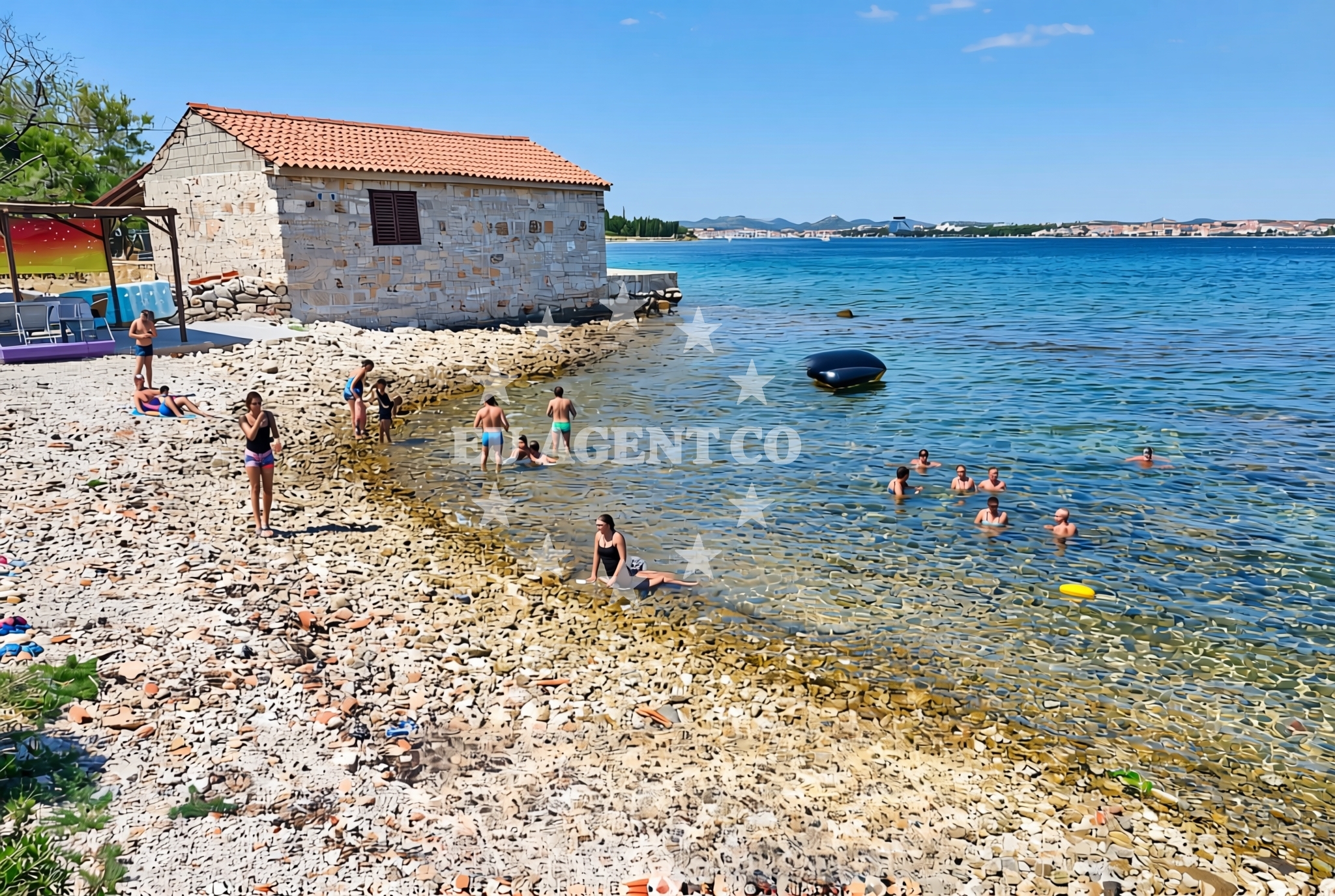
The beach consists of a mix of gravel, concrete slabs, and exposed rock formations, reflecting its natural coastal profile. The terrain is uneven, with no dedicated sand or soft-surface areas. The beach's short length (40 meters) and rocky composition suggest it is more suited for brief access or as a transitional landing point rather than extended leisure activities. The lack of structured amenities or facilities is consistent with its undeveloped character, aligning with the island's preservation of traditional landscapes.Swimming and shore
Swimming conditions at Lučica are influenced by its rocky shoreline and proximity to the open sea. The beach's gravel and stone composition make it unsuitable for wading or extended water activities, with limited shallow areas for safe entry. The shore itself is uneven, requiring caution when navigating the terrain. The beach's orientation and surrounding geography likely contribute to variable wave patterns, though no specific data on water depth or currents is available.Facilities and activities
No formal facilities, such as showers, toilets, or seating, are explicitly documented for Lučica Beach. The absence of structured amenities aligns with its undeveloped status. Activities associated with the beach are not specified in the catalog, though its location on Prvić may offer opportunities for coastal hiking, fishing, or boat access. The beach's characteristics suggest it is not designed for recreational use beyond brief visits or as a point of passage.Access and location
Lučica Beach is located on the island of Prvić, approximately 15 kilometers northeast of the town of Supetar on the island of Brac. The island of Prvić is part of the Adriatic's Dalmatian coast, known for its medieval villages, vineyards, and proximity to the mainland. Access to the beach likely requires local transportation, such as a boat or walking from nearby settlements. The coordinates (43.736151, 15.791919) place it within a region of significant maritime history and natural beauty.What to expect
Expect a short, rugged shoreline composed of gravel, concrete slabs, and rocks, with no formal facilities or structured amenities. The beach's undeveloped nature makes it unsuitable for extended stays or recreational activities. Its location on the island of Prvić offers proximity to traditional coastal landscapes, historical sites, and the broader Adriatic sailing routes. Visitors should prepare for uneven terrain and limited accessibility, with no guarantees of privacy or comfort.Practical tips
Given the beach's rocky composition and lack of facilities, it is advisable to bring appropriate footwear for uneven terrain. The beach's short length and absence of amenities make it more suitable for brief visits rather than extended stays. Local knowledge or maps may be necessary to locate the exact access point, as no specific pathways or parking areas are documented.Exploring the coast by yacht
The area around Lučica Beach is part of the Adriatic's rich sailing network, with the island of Prvić serving as a gateway to the broader Dalmatian coast. Yacht charter guests exploring this region may find the surrounding waters scenic, with opportunities to anchor near other beaches or visit nearby settlements like Supetar. The proximity to the mainland and connections to major Adriatic routes make it a potential stop for sailors navigating between the islands and coastal towns.Historical and Cultural Context
The island of Prvić, where Lučica Beach is located, has a history dating back to the Roman period, with archaeological evidence of ancient settlements. The island's traditional fishing villages and vineyards reflect its long-standing connection to maritime and agricultural life. Nearby, the town of Supetar on Brac is a hub for yachting and cultural tourism, offering insights into the region's heritage.Anchorages in the surrounding area
Anchorages in the surrounding area include nearby options like Prvić Šepurine and Tijat.
- Anchorage — prvic sepurine — 0.1 NM from beach
- Sepurine — prvic sepurine — 0.5 NM from beach
- Anchorage — tijat — 1.5 NM from beach
- Anchorage — jadria — 2.5 NM from beach
- Anchorage — sibenik — 2.8 NM from beach
- Anchorage — zmajan — 2.9 NM from beach
- Anchorage — zmajan — 2.9 NM from beach
- Anchorage — zmajan — 3.3 NM from beach
Distances are straight-line geographic distances, not sailing routes.
Mooring buoys in the surrounding area
- Sepurine east — prvic sepurine — 0.1 NM from beach
- Buoy field — prvic sepurine — 0.4 NM from beach
- Buoy field — prvic — 0.8 NM from beach
- Spirito Summer Place jetty — tijat — 1.4 NM from beach
- Buoy field — tijat — 1.5 NM from beach
Distances are straight-line geographic distances, not sailing routes.
Marine fuel stations
- Ina — vodice — 1.4 NM from beach
- Petrol — tribunj — 2.1 NM from beach
- Ina — sibenik — 4.3 NM from beach
- Lukoil — sibenik — 4.4 NM from beach
Distances are straight-line geographic distances, not sailing routes.
Harbours in the surrounding area
Harbors like Prvić Šepurine and Vodice are located in proximity to the beach.
- Prvić Šepurine — prvic sepurine — 0.3 NM from beach
- Srima — 0.6 NM from beach
- Konoba Stari Nanini at Prvić Port — prvic — 0.8 NM from beach
- Vodice — 1.4 NM from beach
- Tribunj — 2.3 NM from beach
- Jadria — 2.5 NM from beach
Distances are straight-line geographic distances, not sailing routes.
Marinas in the surrounding area
- ACI Marina Vodice — 1.4 NM from beach
- Marina Tribunj — 2.2 NM from beach
- Marina Zaton — zaton near sibenik — 3.1 NM from beach
- Amadria Yacht Marines — sibenik — 4.3 NM from beach
- Marina Mandalina — sibenik — 4.8 NM from beach
Distances are straight-line geographic distances, not sailing routes.
Restaurants near the beach
Restaurants such as Konoba Bare and Ribarski Dvor are situated near Prvić Šepurine.
- Konoba Bare — prvic sepurine — 0.2 NM from beach
- Ribarski Dvor — prvic sepurine — 0.4 NM from beach
- Konoba Stari Nanini — prvic — 0.7 NM from beach
- Nanini — prvic — 0.7 NM from beach
- Konoba Makina — prvic — 0.7 NM from beach
- Val — prvic — 0.8 NM from beach
- Mareta — prvic — 0.8 NM from beach
Distances are straight-line geographic distances, not sailing routes.
Navigation guides for the surrounding area
- Vodice — 1.3 NM from beach
- Tribunj — 2.1 NM from beach
- Luka Zlarin — 2.9 NM from beach
- Uvala Sovlje — 3.0 NM from beach
- Zaton — 3.5 NM from beach
Distances are straight-line geographic distances, not sailing routes.
Yachts from nearby departure bases
Yachts departing from Vodice Port and ACI Marina are located near the beach.
Sailing yachts
- Dufour 412 Grand large (THEMISTO) — Vodice ACI Marina — 1.4 NM from departure base to beach
- Elan Impression 45 (Mirakul) — Vodice ACI Marina — 1.4 NM from departure base to beach
Motor boats
- Axopar 37 Sun Top (Axe) — Vodice port — 1.4 NM from departure base to beach
- Marlin 790 Dynamic (Marlin) — Vodice Port — 1.4 NM from departure base to beach
- Salpa Sunsix (Ika) — Vodice Port — 1.4 NM from departure base to beach
- Salpa Soleil 18 (Salpa) — Vodice Port — 1.4 NM from departure base to beach
- Salpa Soleil 24.5 (Zaostrog) — Vodice Port — 1.4 NM from departure base to beach
- Salpa Soleil 20 (Salpa) — Vodice Port — 1.4 NM from departure base to beach
- Salpa Soleil 26 (Podgora) — Vodice Port — 1.4 NM from departure base to beach
- Merry Fisher 795 (Brac) — Vodice Port — 1.4 NM from departure base to beach
Distances are straight-line geographic distances, not sailing routes.