Donja Prezida jug, Vir (Vir) Beach, Croatia
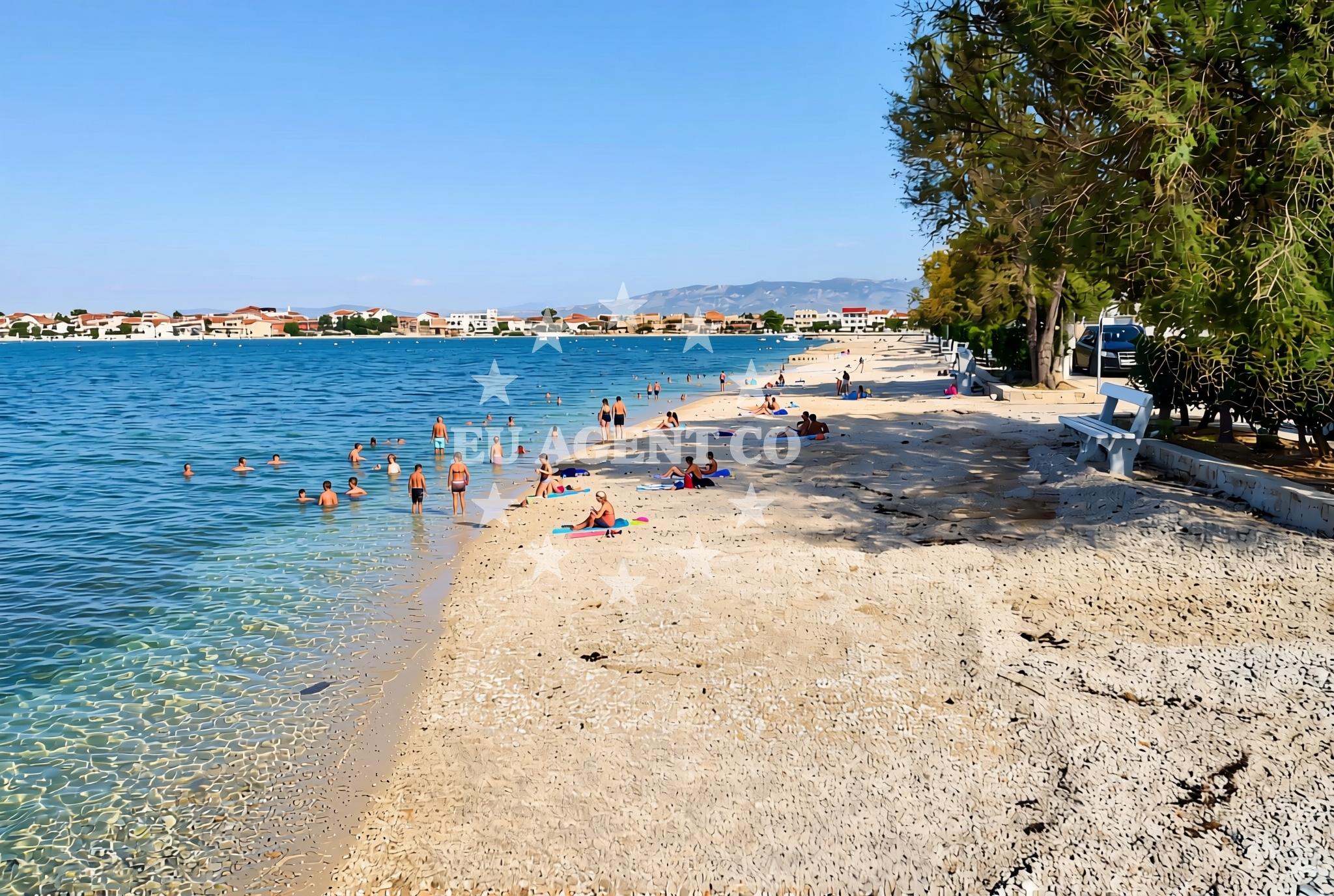
About this beach
Donja Prezida jug, Vir (Vir)
Beach: Donja Prezida jug
Location: Vir (Vir)
Characteristics and facilities
Gravel, concrete / stone slabs
450 m
Restaurant / snack bar
Caffe bar / Drinks stand
Natural shade
Beach character
The beach's surface is composed of gravel and concrete/stone slabs, creating a utilitarian yet accessible shoreline. This composition suggests it may be a more functional or less developed stretch of coast, possibly serving as a transitional area between natural rock formations and human-modified surfaces. The 450-meter length provides a modest shoreline for visitors, though the lack of detailed natural features or recreational infrastructure implies a focus on basic coastal access rather than leisure-oriented amenities.Swimming and shore
The shoreline's gravel and stone slabs indicate a firm, unsoftened beach surface, which may affect comfort for barefoot swimmers. The absence of structured swimming areas or lifeguard services suggests this is not a primary destination for water sports or family recreation. However, the natural shade provided by nearby terrain or vegetation offers a practical benefit for visitors seeking respite from the sun.Facilities and activities
On-site facilities include a restaurant/snack bar and a caffe bar/drinks stand, providing basic refreshments for visitors. These amenities cater to those seeking a quick meal or beverage while enjoying the coastal setting. The lack of structured activities or recreational equipment indicates this beach is best suited for passive relaxation rather than organized entertainment.Access and location
Located in Donja Prezida jug, part of the Vir settlement, the beach is positioned along the southern coast of the island of Vir. This area is part of the broader Dalmatian Coast, a region marked by its dramatic cliffs, historic maritime villages, and clear waters. Its proximity to Vir's main settlement suggests potential for local exploration, though specific road or pedestrian access details are not documented in the beach's authoritative features.What to expect
Expect a beach with a gravel and stone-slab shoreline, offering a 450-meter stretch of coast with minimal recreational infrastructure. On-site dining options include a restaurant/snack bar and a caffe bar/drinks stand, suitable for light meals or refreshments. Natural shade is available, though the beach does not appear to prioritize comfort or leisure amenities. Its location within Vir places it near the Dalmatian Coast's broader attractions, including historic villages and yacht-friendly waters.Practical tips
Given the beach's gravel and stone-slab surface, consider wearing sturdy footwear for comfort. The on-site dining options are ideal for quick meals, but visitors should bring personal items for extended stays. The natural shade is a practical feature for sun protection, though limited to specific areas.Exploring the coast by yacht
The Vir coastline, including Donja Prezida jug, lies within a region popular with yacht charter guests due to its sheltered bays, clear waters, and proximity to historic maritime routes. Nearby anchorages and marinas along the Dalmatian Coast provide convenient bases for exploring the Adriatic. While this specific beach may not serve as a primary docking point, the surrounding area offers sailing opportunities for those seeking coastal navigation or island-hopping excursions.Regional Context: Vir and the Dalmatian Coast
The island of Vir, part of the Šibenik-Knin County, is known for its traditional stone houses, olive groves, and connection to the Adriatic's maritime heritage. The Dalmatian Coast, where Vir is located, is characterized by its deep inlets, limestone cliffs, and a network of small islands that make it a favored region for sailing. Local traditions and seasonal festivals in nearby settlements add cultural depth to the area, though specific events related to Donja Prezida jug are not documented.Anchorages in the surrounding area
Anchorages near Vir offer convenient mooring options in the surrounding area.
- Anchorage — vir — 0.2 NM from beach
- Anchorage — privlaka — 1.3 NM from beach
- Anchorage — vir — 1.4 NM from beach
- Anchorage — vir — 1.6 NM from beach
- Anchorage — vir — 1.7 NM from beach
- Anchorage — privlaka — 2.5 NM from beach
- Anchorage — povljana — pag — 2.6 NM from beach
- Anchorage — povljana — pag — 3.2 NM from beach
Distances are straight-line geographic distances, not sailing routes.
Mooring buoys in the surrounding area
- Vir — 1.5 NM from beach
- Punta Skala — petrcane — 5.8 NM from beach
- Jetty — ljubac — 7.7 NM from beach
- Jetty — ugljan — 9.0 NM from beach
- Buoy field — muline — ugljan — 9.0 NM from beach
Distances are straight-line geographic distances, not sailing routes.
Marine fuel stations
Marine fuel stations in Zadar and Ugljan ensure refueling options for yachts in the region.
- Ina — zadar — 11.2 NM from beach
- Ina — preko — ugljan — 13.1 NM from beach
- Fuel station — sukosan — 16.1 NM from beach
- Ina — zaglav — dugi otok — 20.3 NM from beach
Distances are straight-line geographic distances, not sailing routes.
Harbours in the surrounding area
- Privlaka — 1.3 NM from beach
- Povljana — pag — 3.5 NM from beach
- Nin — 3.7 NM from beach
- Mulo — nin — 4.4 NM from beach
- Miškovići — miskovici — pag — 5.6 NM from beach
- Petrčane — petrcane — 6.4 NM from beach
Distances are straight-line geographic distances, not sailing routes.
Marinas in the surrounding area
- Marina Borik — zadar — 10.3 NM from beach
- Vitrenjak Zadar — 10.5 NM from beach
- Marina Zadar — 11.2 NM from beach
- Olive Island Marina — sutomiscica — ugljan — 11.7 NM from beach
- Marina Preko — ugljan — 12.8 NM from beach
Distances are straight-line geographic distances, not sailing routes.
Restaurants near the beach
Restaurants in Vir and nearby areas offer dining options close to Donja Prezida jug Beach.
- Restaurant — vir — 0.3 NM from beach
- Grill Marion — vir — 0.7 NM from beach
- Restaurant — vir — 1.2 NM from beach
- Monica — vir — 1.5 NM from beach
- Viranka — 1.6 NM from beach
- Restaurant — vir — 1.6 NM from beach
- Mornar — povljana — pag — 3.6 NM from beach
Distances are straight-line geographic distances, not sailing routes.
Navigation guides for the surrounding area
Navigation guides for Privlaka, Otok Pag, and Ugljan assist in route planning around the bay.
- Privlaka — 1.3 NM from beach
- OTOK PAG — 1.8 NM from beach
- Muline — 9.0 NM from beach
- Ugljan — 9.4 NM from beach
- KrusCica and Uvala KrusCica Duboka — 9.5 NM from beach
Distances are straight-line geographic distances, not sailing routes.
Yachts from nearby departure bases
Yachts operate from nearby bases like Povljana Marina and Zadar Diklo Port.
Sailing yachts
- Oceanis 46.1 (Antonela M.) — Zadar Marina Borik — 10.3 NM from departure base to beach
- Oceanis 46.1 (Sevid) — Zadar Marina Borik — 10.3 NM from departure base to beach
Catamarans
- Leopard 50 (Solaia) — Zadar Marina Borik — 10.3 NM from departure base to beach
Motor yachts
- Ferretti 780 (TESORO) — Zadar Marina Borik — 10.3 NM from departure base to beach
Motor boats
- Merry Fisher 895 — Povljana Marina — 3.7 NM from departure base to beach
- Rancraft RS Cinque.5 — Zadar Diklo Port — 8.9 NM from departure base to beach
- Rancraft RM19 (Daycruiser) — Zadar Diklo Port — 8.9 NM from departure base to beach
- Rancraft RM21 (Dugi otok) — Zadar Diklo Port — 8.9 NM from departure base to beach
- BWA Sport 22GT (BWA ) — Pag City Port — 9.8 NM from departure base to beach
- Merry Fisher 895 (Joy) — Zadar Marina Borik — 10.3 NM from departure base to beach
Distances are straight-line geographic distances, not sailing routes.