Dešenja, Nečujam (Šolta) Beach, Croatia
6 photos
About this beach
Dešenja, Nečujam (Šolta)
Beach: Dešenja
Location: Nečujam (Šolta)
Characteristics and facilities
Gravel, rocks
Beach character
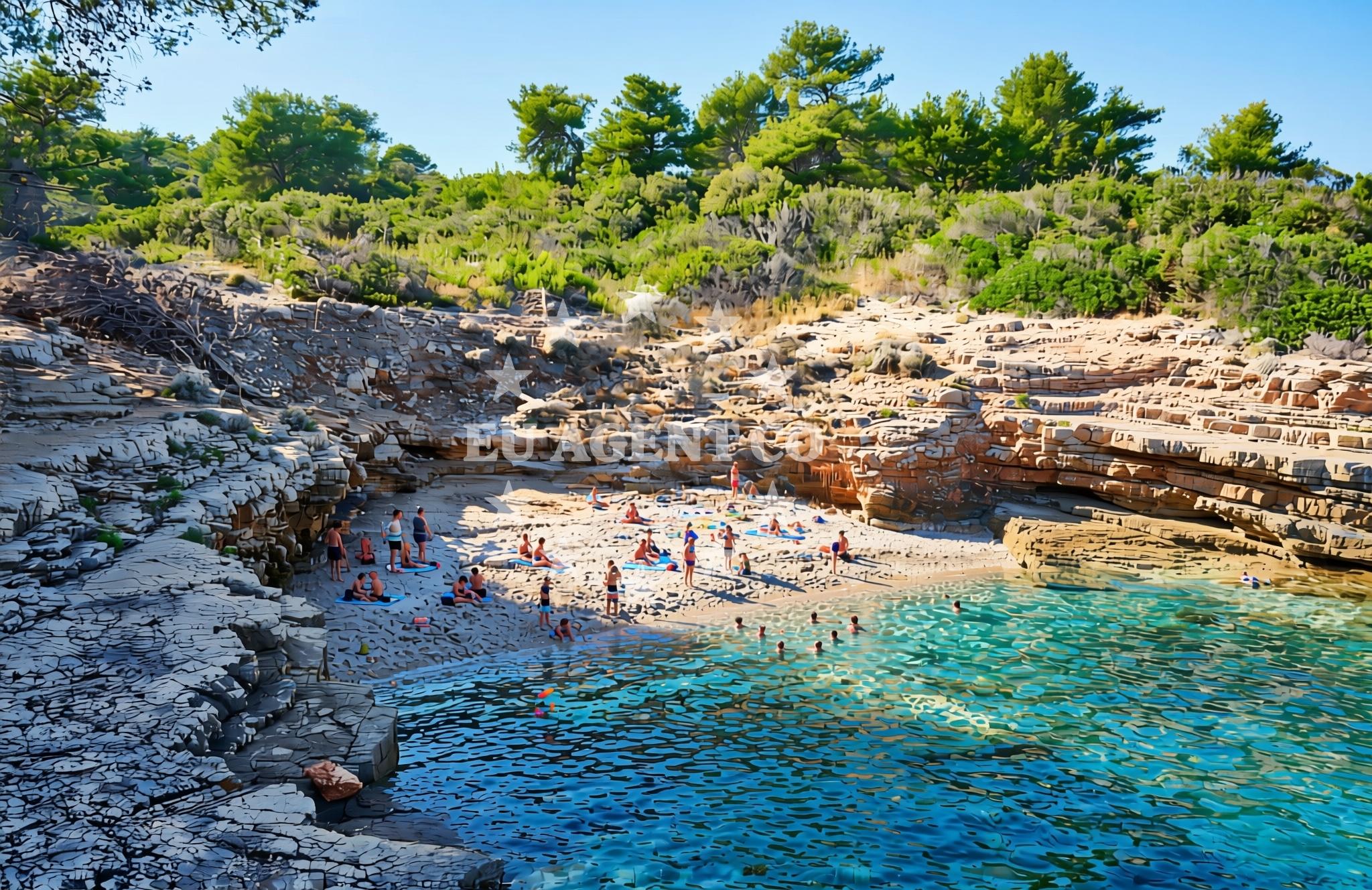
The beach is defined by its gravel and rocky composition, reflecting Šolta’s limestone bedrock and coastal erosion patterns. The shoreline slopes gently into the sea, with larger rocks interspersed among smaller gravel deposits. This terrain creates a dynamic environment where wave action shapes the landscape, making it a site of interest for geology enthusiasts. The lack of sand gives the beach a distinct, almost lunar quality, particularly during low tide when exposed rock formations become more pronounced.Swimming and shore
Swimming conditions here are influenced by the rocky terrain. The gravel and boulders create uneven entry points into the water, making it unsuitable for young children or those seeking a gradual wade. However, the rocky shore offers sheltered coves during calm weather, where the sea is relatively tranquil. Stronger currents and wave action near the rocks may limit swimming to experienced swimmers. The beach’s character is best appreciated from a distance, where the interplay of rock and sea creates a striking visual contrast.Facilities and activities
There are no formal facilities at Dešenja, Nečujam (Šolta) Beach. The absence of amenities such as restrooms, showers, or seating reflects its status as a more remote, natural site. Activities are limited to passive enjoyment of the landscape, though the beach’s proximity to Šolta’s trails and vineyards offers opportunities for hiking or exploring the island’s agricultural heritage. No structured recreational activities are reported, but the area’s isolation makes it ideal for solitary reflection or photography.Access and location
The beach is located in the village of Nečujam on Šolta’s southern coast, approximately 15 kilometers from the island’s main settlement of Šolta. Access requires a combination of road and foot travel: the nearest road access point is via the Šolta–Brač ferry route, which connects to the mainland and nearby islands. From the village of Nečujam, the beach is reachable via a short walk along a gravel path that follows the coastline. The site’s remoteness makes it less accessible for day-trippers but appealing to those seeking solitude.What to expect
Expect a rugged, unspoiled shoreline defined by gravel and rock formations. The beach is not suited for sunbathing or family outings but offers a unique perspective on Šolta’s coastal geology. Visitors should prepare for uneven terrain and limited facilities. The site’s isolation means it is rarely crowded, making it a peaceful destination for those seeking a quiet escape. The surrounding area includes Šolta’s vineyards and olive groves, which can be explored on foot or by bike.Practical tips
Wear sturdy footwear to navigate the gravel and rocky terrain. Bring a towel or mat for sitting on the beach, as there are no designated areas for relaxation. Check tide times to avoid being caught on exposed rocks during low tide. The lack of shade means sun protection is essential, even in the early morning or late afternoon.Exploring the coast by yacht
For yacht charter guests, Dešenja, Nečujam (Šolta) Beach lies within a popular sailing area of the Adriatic, where Šolta’s sheltered waters and proximity to Split and Brač make it a common stop. While the beach itself is not a marina or anchorage, the nearby village of Nečujam offers access to Šolta’s maritime routes. Euro-Agent Yacht Charter can assist with planning itineraries that include Šolta’s coastline, with options to anchor in nearby bays or dock at the island’s marinas. The beach’s location highlights the appeal of exploring Croatia’s lesser-known islands via private yacht.Šolta’s Cultural and Natural Context
Šolta is one of the Šibenik archipelago’s smallest islands, known for its vineyards and historical ties to the Counts of Šolta. The island’s landscape is a mix of rugged coastlines, fertile valleys, and medieval fortifications. Nečujam, where the beach is located, was historically a center of winemaking, with traditions that continue today. The island’s proximity to Split (35 kilometers) and Brač (7 kilometers) makes it a strategic point for exploring the Adriatic’s southern routes.Anchorages in the surrounding area
- Anchorage — necujam — solta — 1.5 NM from beach
- Anchorage — necujam — solta — 1.5 NM from beach
- Anchorage — necujam — solta — 1.6 NM from beach
- Anchorage — necujam — solta — 1.6 NM from beach
- Anchorage — stomorska — solta — 1.6 NM from beach
- Anchorage — solta — 2.0 NM from beach
- Anchorage — solta — 2.1 NM from beach
- Anchorage — rogac — solta — 2.1 NM from beach
Distances are straight-line geographic distances, not sailing routes.
Mooring buoys in the surrounding area
- Jetty — necujam — solta — 1.0 NM from beach
- Resturant Sveti Petar bouy — necujam — solta — 1.2 NM from beach
- Pasarela restaurant jetty — rogac — solta — 2.2 NM from beach
- Buoy field — solta — 2.4 NM from beach
- Lonely Paradise restaurant buoys — solta — 2.6 NM from beach
Distances are straight-line geographic distances, not sailing routes.
Marine fuel stations
- Fuel station — rogac — solta — 2.3 NM from beach
- Ina — milna brac — 5.2 NM from beach
- Ina — split — 8.5 NM from beach
- Ina — split — 8.9 NM from beach
Distances are straight-line geographic distances, not sailing routes.
Harbours in the surrounding area
- Stomorska — solta — 0.5 NM from beach
- Rogač — rogac — solta — 2.3 NM from beach
- Milna — milna brac — 5.3 NM from beach
- Bobovišće — bobovisce — brac — 5.3 NM from beach
- Sutivan — brac — 5.8 NM from beach
- Slatine — ciovo — 7.3 NM from beach
Distances are straight-line geographic distances, not sailing routes.
Marinas in the surrounding area
- Marina Vlaška — milna brac — 5.0 NM from beach
- Marina Milna Kanarija — milna brac — 5.3 NM from beach
- ACI Marina Milna — milna brac — 5.4 NM from beach
- Marina Martinis Marchi — maslinica — solta — 6.2 NM from beach
- ACI Marina Split — 8.3 NM from beach
Distances are straight-line geographic distances, not sailing routes.
Restaurants near the beach
- Zlato — stomorska — solta — 0.5 NM from beach
- Hundred Seas Luna — stomorska — solta — 0.5 NM from beach
- Komin — stomorska — solta — 0.5 NM from beach
- Restoran Pizzeria Turanj — stomorska — solta — 0.5 NM from beach
- Konoba Luna — stomorska — solta — 0.5 NM from beach
- O´la la — stomorska — solta — 0.5 NM from beach
- Volat — stomorska — solta — 0.6 NM from beach
Distances are straight-line geographic distances, not sailing routes.
Navigation guides for the surrounding area
- Stomorska — 0.5 NM from beach
- Uvala Necujam — 1.2 NM from beach
- Uvala Gornja Krusica — 1.7 NM from beach
- Rogac — 2.0 NM from beach
- Uvala Tatinja — 2.6 NM from beach
Distances are straight-line geographic distances, not sailing routes.
Yachts from nearby departure bases
Sailing yachts
- Sun Odyssey 449 (Tortuga) — Šolta Rogač — 2.3 NM from departure base to beach
- Cyclades 39.3 (Alaska) — Šolta Rogač — 2.3 NM from departure base to beach
- Sun Odyssey 349 (Siberia) — Šolta Rogač — 2.3 NM from departure base to beach
- Cyclades 43.4 (Niagara) — Šolta Rogač — 2.3 NM from departure base to beach
- Oceanis 50 Family (Mississippi) — Šolta Rogač — 2.3 NM from departure base to beach
Catamarans
- Lagoon 40 (Solentia) — Šolta Rogač — 2.3 NM from departure base to beach
- Lagoon 450 Flybridge (Samogon) — Šolta Rogač — 2.3 NM from departure base to beach
- Lagoon 42 (Galapagos) — Šolta Rogač — 2.3 NM from departure base to beach
- Lagoon 450 (Madagascar) — Šolta Rogač — 2.3 NM from departure base to beach
- Lagoon 400 (Greenland) — Šolta Rogač — 2.3 NM from departure base to beach
Distances are straight-line geographic distances, not sailing routes.
Frequently asked questions
Is Dešenja, Nečujam (Šolta) Beach suitable for families with young children?
The beach’s gravel and rocky terrain make it unsuitable for young children, as the uneven surface and lack of shallow, gradual entry points into the water pose safety risks.Can I reach the beach by boat?
While the beach itself is not a docking point, the nearby village of Nečujam is accessible by ferry from the mainland and nearby islands. Yacht charter guests can anchor in nearby bays and walk to the beach.Nearby beaches
Africa's beach
39 Riva Pelegrina, Stomorska
0.5 km
Veli Dolacbeach
Sv. Nikole 27, Stomorska
0.6 km
Veli dolac (dog beach), Stomorska (Šolta)
Veli dolac (plaža za pse)
0.7 km
Belinda's beach
Varica 33., Stomorska
0.8 km
Stomorska luka, Stomorska (Šolta) Beach
Stomorska luka
0.9 km
Stomorska (Šolta): beaches and coves (7)
Stomorska (Šolta)
1.1 km
Pelegrin, Stomorska (Šolta) Beach
Pelegrin
1.5 km
Prirodna Kameita Plaza
Put rata 36A, Nečujam
1.5 km