Punta, Klada Beach, Croatia
About this beach
Punta, Klada
Beach: Punta
Location: Klada
Characteristics and facilities
Concrete / stone slabs
70 m
Beach character
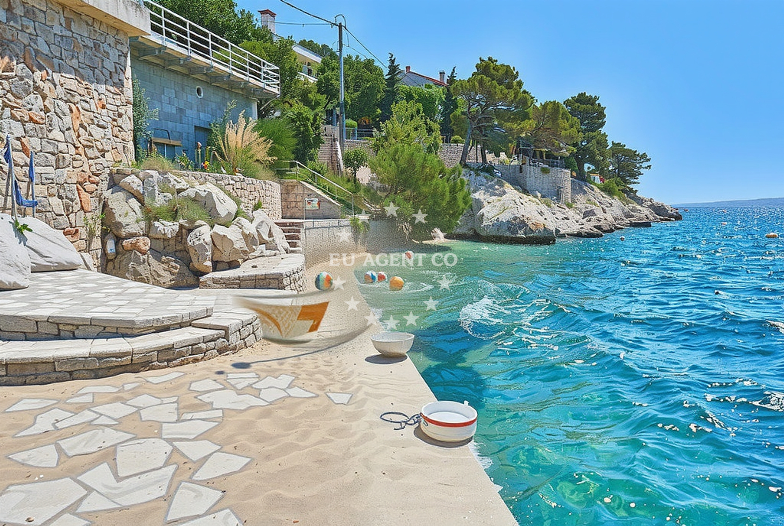
The beach's most notable feature is its composition of concrete and stone slabs, which create a textured shoreline. This characteristic, while unconventional, reflects the natural geological formations of the area. The beach stretches 70 meters along the coast, providing a compact space for visitors to enjoy the surrounding scenery. The absence of traditional sand or pebbles makes it a distinctive spot for those seeking a different coastal experience.Swimming and shore
While specific details about swimming conditions are not documented, the beach's proximity to the open sea suggests access to the Adriatic's renowned clear waters. The shore's concrete and stone slabs may offer limited opportunities for wading, though visitors should be mindful of the terrain when approaching the water's edge.Facilities and activities
The beach does not list specific amenities or activities in its authoritative records. However, the surrounding area of Punta on Vis is known for its natural beauty and limited infrastructure, focusing more on raw coastal experiences than developed facilities. Nearby, the island of Vis offers opportunities for hiking, exploring historic sites, and enjoying the unspoiled landscapes of the Adriatic.Access and location
Punta, Klada Beach is located in the village of Punta on the island of Vis, Croatia. The coordinates (44.819223, 14.880646) place it along the southern coast of Vis, a region celebrated for its tranquil waters and scenic cliffs. Access to the beach is likely via local roads connecting Punta to the rest of the island. The area is part of a broader network of coastal villages in the Adriatic, offering a range of experiences from secluded coves to bustling marinas.What to expect
Visitors to Punta, Klada Beach can expect a unique shoreline defined by concrete and stone slabs, set against the backdrop of the Adriatic Sea. The beach's compact size and lack of traditional amenities make it an ideal spot for those seeking a quiet, unconventional coastal experience. The surrounding area of Punta on Vis offers opportunities to explore the island's natural landscapes, including its historic sites and rugged coastline.Practical tips
Given the beach's unique composition, visitors may want to wear appropriate footwear for walking on concrete and stone surfaces. The area's limited infrastructure means facilities such as restrooms or refreshments may not be readily available. For those interested in exploring the region further, the nearby island of Vis provides a range of outdoor activities and cultural attractions.Exploring the coast by yacht
The waters surrounding Punta, Klada Beach are part of the Adriatic Sea's renowned sailing routes, particularly popular among yacht charter guests. The island of Vis, where the beach is located, is a favored destination for sailors due to its sheltered bays, clear waters, and proximity to other Dalmatian islands. For those interested in yacht charters in the region, Euro-Agent offers access to a variety of motor and sail yachts available for booking through their Yacht Search page at https://euro-agent.com/?open=form.The Island of Vis: A Yacht Sailing Destination
Vis, home to Punta, Klada Beach, is a protected island in Croatia's Adriatic coast, known for its unspoiled natural beauty and historical significance. The island's coastline features a mix of rugged cliffs, secluded coves, and calm bays, making it an ideal location for yacht charters. Visitors can explore the island's UNESCO-listed sites, such as the village of Komiza and the ancient Roman ruins of the Villa of the Diocletians. The surrounding waters are part of a larger sailing network that includes the nearby islands of Hvar, Brac, and Korcula, offering diverse experiences for sailors.Anchorages in the surrounding area
Anchorages near Uvala Klada include Lukovo, Stinica, and Rab.
- Anchorage — lukovo — 2.2 NM from beach
- Anchorage — stinica — 5.1 NM from beach
- Anchorage — zrnovnica — 5.3 NM from beach
- Anchorage — rab — 5.5 NM from beach
- Anchorage — lopar — rab — 5.9 NM from beach
- Anchorage — rab — 5.9 NM from beach
- Mag — misnjak — rab — 6.2 NM from beach
- Anchorage — rab — 6.3 NM from beach
Distances are straight-line geographic distances, not sailing routes.
Mooring buoys in the surrounding area
Mooring buoys in the surrounding area are located at Goli Otok, Zrnovnica, and Rab.
- Quay — goli otok — 3.5 NM from beach
- Quay — zrnovnica — 4.8 NM from beach
- Quay — zrnovnica — 5.3 NM from beach
- Banjol — rab — 6.0 NM from beach
- Jetty — barbat — rab — 6.1 NM from beach
Distances are straight-line geographic distances, not sailing routes.
Marine fuel stations
- Ina — rab — 6.2 NM from beach
- Flash — krk — 17.9 NM from beach
- Ina — krk — 18.0 NM from beach
- INA — novi vinodolski — 18.8 NM from beach
Distances are straight-line geographic distances, not sailing routes.
Harbours in the surrounding area
Harbours in the surrounding area include Starigrad, Lukovo, and Mala Stinica.
- Starigrad — starigrad senj — 1.3 NM from beach
- Lukovo — 2.2 NM from beach
- Melna — goli otok — 3.7 NM from beach
- San Marino — lopar — rab — 5.7 NM from beach
- Mala Stinica — 6.0 NM from beach
- Pičuljan dock — barbat — rab — 6.1 NM from beach
Distances are straight-line geographic distances, not sailing routes.
Marinas in the surrounding area
Marinas in Rab, Supetarska Draga, and Krk are situated within reach of the beach.
- ACI Marina Rab — 6.2 NM from beach
- ACI Marina Supetarska Draga — rab — 6.7 NM from beach
- Marina Punat — krk — 16.6 NM from beach
- Mitan Marina — novi vinodolski — 18.4 NM from beach
- Marina Novi — novi vinodolski — 18.9 NM from beach
Distances are straight-line geographic distances, not sailing routes.
Restaurants near the beach
A restaurant named Porat on Goli Otok is located close to the beach.
- Porat — goli otok — 3.5 NM from beach
Distances are straight-line geographic distances, not sailing routes.
Navigation guides for the surrounding area
- Uvala Klada — 0.4 NM from beach
- Uvala Stinica — 5.8 NM from beach
- Rab — 6.1 NM from beach
- Uvala Sv. Fumija — 6.6 NM from beach
- Uvala Misnjak — 6.8 NM from beach
Distances are straight-line geographic distances, not sailing routes.
Yachts from nearby departure bases
Sailing yachts
- First 25.7 (Petra) — Krk Punat port — 16.3 NM from departure base to beach
- Salona 45 (Nati) — Krk Punat port — 16.3 NM from departure base to beach
- Bavaria C42 (PALMA) — Krk Marina Punat — 16.6 NM from departure base to beach
Catamarans
- Lagoon 380 (Xenia) — Krk Punat port — 16.3 NM from departure base to beach
- Lagoon 42 (Marianne) — Krk Marina Punat — 16.6 NM from departure base to beach
Motor yachts
- Absolute 50 Fly (Acrobat) — Rab ACI Marina — 6.2 NM from departure base to beach
- Elegance 60 Fly (LIFESTYLE 1) — Krk Marina Punat — 16.6 NM from departure base to beach
Motor boats
- Balt 818 Titanium (Valentina) — Novalja — 15.8 NM from departure base to beach
- Balt 818 Titanium (Valentina 2) — Novalja — 15.8 NM from departure base to beach
- Prestige 36 Fly (Fortuna) — Krk Marina Punat — 16.6 NM from departure base to beach
Distances are straight-line geographic distances, not sailing routes.