Punta II Beach - Igrane, Croatia
Beach character
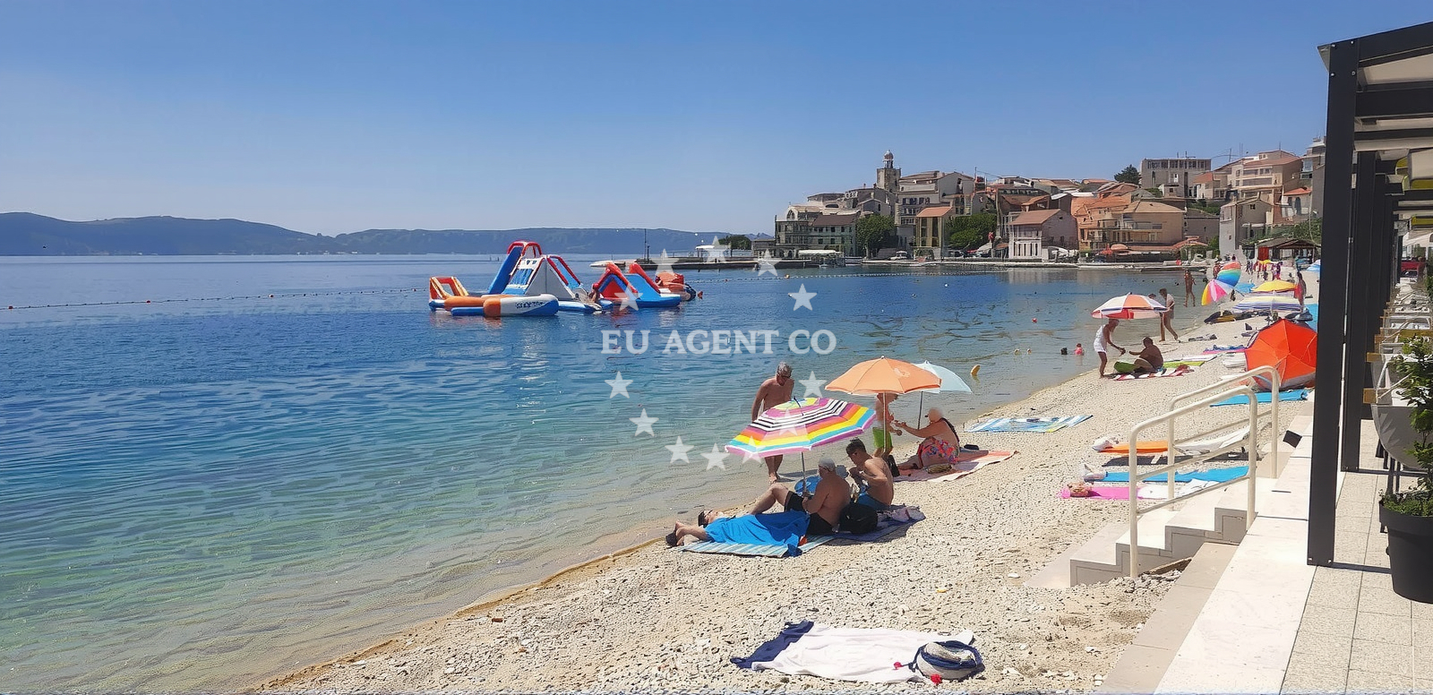
The beach's cove shape creates a sheltered environment, though the sea floor consists of small pebbles that may require careful footing. The depth increases sharply as one enters the water, making it a safer option for swimmers who can navigate the transition from the pebble-covered shore. The beach's mountainous backdrop provides a striking contrast to the sea, offering panoramic views that are particularly notable during sunrise and sunset.Swimming and shore
Swimming conditions are generally suitable for all ages, with the beach marked as recommended for children. The sharp depth increase near the shore means swimmers should exercise caution when entering the water. The pebble-covered surface may require beachgoers to wear appropriate footwear for comfort, though the beach remains accessible to those with mobility needs.Facilities and activities
Punta II Beach does not feature structured amenities such as showers, toilets, or umbrellas. However, visitors can engage in kayaking and water entertainment activities. The absence of dedicated facilities means visitors should bring their own equipment for these pursuits. The beach's natural setting makes it an ideal spot for those seeking unstructured outdoor recreation.Access and location
Located at igrane 206/A, Igrane, the beach is part of a small coastal town known for its traditional architecture and proximity to the Adriatic Sea. Igrane itself is a quiet settlement with a focus on local tourism, offering visitors a chance to explore nearby villages and historical sites. The beach's position within the town makes it easily accessible by foot or vehicle from local accommodations.What visitors say
Visitors have shared varied experiences at Punta II Beach. One reviewer noted, 'Everythings ok, the place is beautiful 🤩,' highlighting the beach's scenic appeal. Another mentioned, 'Really nice beach but no shady places,' indicating that sun protection is essential during peak hours. A third visitor described it as 'Lovely public beach in Igrane, at the seafront of this small town,' with observations about the pebble surface being 'not entirely natural, but fine.'
Practical tips
Given the lack of shaded areas, visitors are advised to bring sunscreen and hats. The pebble surface may require sturdy footwear for comfort. Those planning to swim should be mindful of the sharp depth increase near the shore.
Exploring the coast by yacht
For visitors exploring the Adriatic coast by yacht, Punta II Beach offers a convenient stopover near Igrane. The surrounding area includes several marinas and anchorages that cater to both motor and sailing yachts. The proximity to Igrane means visitors can combine beach relaxation with exploring the town's maritime heritage and nearby sailing routes.
Video Documentation
A video review of Punta II Beach is available here, providing a visual perspective of the beach's features and surroundings.
Anchorages in the surrounding area
Anchorages in Sucuraj and Selca Kod Bogomolja on Hvar are nearby.
- Anchorage — sucuraj — hvar — 3.5 NM from beach
- Anchorage — selca kod bogomolja — hvar — 4.0 NM from beach
- Anchorage — sucuraj — hvar — 4.6 NM from beach
- Anchorage — sucuraj — hvar — 4.6 NM from beach
- Anchorage — selca kod bogomolja — hvar — 4.6 NM from beach
- Anchorage — selca kod bogomolja — hvar — 4.6 NM from beach
- Anchorage — sucuraj — hvar — 4.7 NM from beach
- Anchorage — selca kod bogomolja — hvar — 5.1 NM from beach
Distances are straight-line geographic distances, not sailing routes.
Mooring buoys in the surrounding area
Mooring buoys at Kraj Soline in Drasnice, Jetty in Sucuraj, and Konoba Gambo in Selca Kod Bogomolja are in the vicinity.
- Kraj - Soline — kraj soline — drasnice — 2.0 NM from beach
- Jetty — sucuraj — hvar — 4.7 NM from beach
- Konoba Gambo buoys — selca kod bogomolja — hvar — 5.1 NM from beach
- Drvenik - Ferry dock — drvenik ferry dock — 5.3 NM from beach
- Quay — bogomolje — hvar — 6.5 NM from beach
Distances are straight-line geographic distances, not sailing routes.
Marine fuel stations
Fuel stations in Makarska, Brac, Korcula, and Ploce are located in surrounding areas.
- Ina — makarska — 8.1 NM from beach
- Fuel station — sumartin — brac — 13.5 NM from beach
- Fuel station — korcula — 14.5 NM from beach
- Fuel station — ploce — 15.4 NM from beach
Distances are straight-line geographic distances, not sailing routes.
Harbours in the surrounding area
- Igrane — 0.1 NM from beach
- Živogošće — zivogosce — 0.8 NM from beach
- Drašnice — drasnice — 1.9 NM from beach
- Čaklje — caklje — podgora — 3.2 NM from beach
- Podgora — 4.2 NM from beach
- Sućuraj — sucuraj — hvar — 4.7 NM from beach
Distances are straight-line geographic distances, not sailing routes.
Marinas in the surrounding area
Marinas in Tučepi, Ramova, Baska Voda, and Korcula are situated in nearby coastal areas.
- Marina Tučepi — marina tucepi — 5.5 NM from beach
- Marina Ramova — krvavica — 10.4 NM from beach
- Marina Baška Voda — marina baska voda — 13.0 NM from beach
- ACI Marina Korčula — korcula — 14.3 NM from beach
- Marina Lumbarda — korcula — 16.4 NM from beach
Distances are straight-line geographic distances, not sailing routes.
Restaurants near the beach
Restaurants in Sucuraj on Hvar are located near the beach.
- Mlaska — sucuraj — hvar — 3.5 NM from beach
- Restaurant — sucuraj — hvar — 4.6 NM from beach
- Riblji Restoran — sucuraj — hvar — 4.7 NM from beach
Distances are straight-line geographic distances, not sailing routes.
Navigation guides for the surrounding area
- Podgora — 3.8 NM from beach
- OTOK HVAR — 5.0 NM from beach
- Uvala Drvenik (Donja Vala) — 5.5 NM from beach
- Uvala Kozja — 6.2 NM from beach
- Uvala Duboka — 6.4 NM from beach
Distances are straight-line geographic distances, not sailing routes.
Yachts from nearby departure bases
Yachts depart from Tučepi Port, Makarska Port, and Baska Voda with sail and motor options.
Sailing yachts
- Bavaria 40 Cruiser (LADY BUTTERFLY) — Tučepi Port — 5.5 NM from departure base to beach
- Sun Odyssey 39i (Mia Pia) — Baška Voda — 12.9 NM from departure base to beach
- Elan 50 Impression (FINES DE CLAIRES) — Baška Voda — 12.9 NM from departure base to beach
Catamarans
- Lagoon 450 (LAMANTIN) — Baška Voda — 12.9 NM from departure base to beach
Motor yachts
- Princess V53 (Chablis) — Makarska Port — 7.9 NM from departure base to beach
- Canados 86 (Karisma) — Baška Voda — 12.9 NM from departure base to beach
Motor boats
- Galeon 430 Skydeck (BELLAGIO) — Makarska Port — 7.9 NM from departure base to beach
- Jeanneau NC 37 (Black Pearl) — Makarska Port — 7.9 NM from departure base to beach
- Galeon 430 Skydeck (Bellagio) — Makarska Port — 7.9 NM from departure base to beach
- Jeanneau NC 37 (Black Pearl) — Makarska Port — 7.9 NM from departure base to beach
Distances are straight-line geographic distances, not sailing routes.
Frequently asked questions
Is Punta II Beach suitable for children?
Yes, the beach is marked as recommended for children, though visitors should be mindful of the pebble surface and sharp depth increase near the shore.Nearby beaches
Reviews
Everythings ok, the place is beautiful 🤩
Really nice beach but no shady places
Lovely public beach in Igrane, at the seafront of this small town. Small pebble is not entirely natural, but fine. See the video: https://youtu.be/UH78crDciFE Split-Dalmatia