Prižba zapad, Blato (Korčula) Beach, Croatia
About this beach
Prižba zapad, Blato (Korčula)
Beach: Prižba zapad
Location: Blato (Korčula)
Characteristics and facilities
Gravel, concrete / stone slabs, rocks
Restaurant / snack bar
Caffe bar / Drinks stand
Beach character
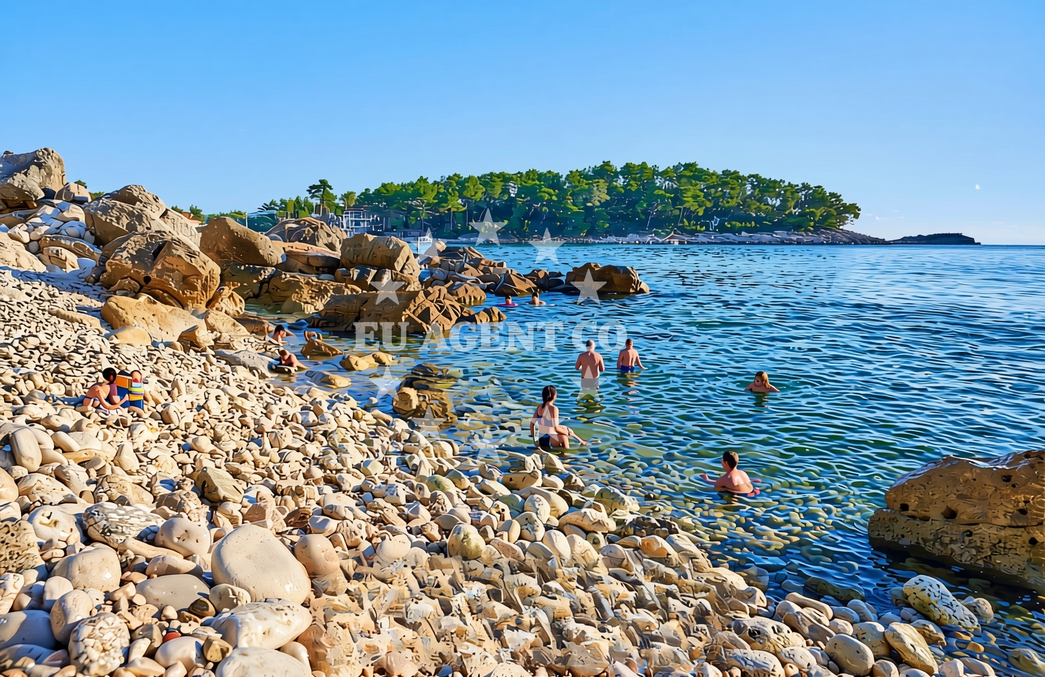
The beach surface consists primarily of gravel, concrete slabs, and exposed rock, making it more suited for casual strolls than sunbathing. The lack of sandy areas means visitors should consider footwear for comfort. The immediate surroundings include a restaurant and a café, providing opportunities for meals and refreshments without needing to travel far. The beach’s character reflects a utilitarian approach to coastal access, typical of smaller settlements where infrastructure prioritizes function over leisure.Swimming and shore
Swimming conditions at Prižba zapad are not explicitly detailed in available records. The rocky shoreline suggests that swimming may be limited to specific areas where the seabed is less uneven. Visitors should exercise caution when entering the water, as the presence of rocks could pose challenges for swimmers unfamiliar with the terrain. The beach’s orientation and proximity to Blato’s inland areas mean it is more likely to be used for brief dips or as a stopping point during coastal excursions.Facilities and activities
The beach is associated with a restaurant, snack bar, and café, which are accessible on-site or in the immediate vicinity. These facilities cater to basic needs, offering food and drinks for visitors. There is no indication of structured activities such as water sports, guided tours, or rental services for equipment. The absence of formal amenities aligns with the beach’s role as a modest coastal access point rather than a destination for active recreation.Access and location
Prižba zapad is situated in Blato, a small settlement on the island of Korčula. Korčula, located in the Adriatic Sea, is part of the Pelješac Peninsula and lies between the islands of Hvar and Šolta. The beach’s proximity to Blato’s inland areas means it is likely accessible via local roads that connect to the broader network of Dalmatian coastal routes. For those arriving by boat, the nearby waters of Blato Bay offer anchorage opportunities, though specific marina details are not outlined in the beach’s records. A map of beaches in the region can provide further context for navigation.What to expect
Visitors to Prižba zapad should expect a shoreline composed of gravel, concrete slabs, and rocks, with no sandy areas for sunbathing. The beach is accompanied by a restaurant, snack bar, and café, making it a convenient spot for light meals or drinks. Its location in Blato, Korčula, positions it near traditional Dalmatian villages, historic sites, and sailing routes. The beach is not designed for extended leisure activities but serves as a functional access point for those exploring the coast or passing through the area.Practical tips
Given the rocky terrain, visitors are advised to wear sturdy footwear for comfort. The on-site dining options make it easy to grab a meal or refreshments without leaving the immediate area. Those planning to explore Korčula’s cultural sites or sailing routes may find the beach a useful starting point for further excursions.Exploring the coast by yacht
For sailors and yacht charter guests, Prižba zapad’s location in Blato offers access to the broader sailing areas of the Pelješac Peninsula. The nearby waters of Blato Bay are known for their sheltered conditions, making them suitable for anchoring or brief stops during coastal cruises. While specific marina details are not outlined for this beach, the surrounding region includes established sailing routes that connect to Korčula’s historic towns, the island of Šolta, and the mainland via the Pelješac Bridge. Yacht charter guests exploring the area may find the beach a convenient reference point for navigation.Cultural and Historical Context of Blato
Blato, the settlement hosting Prižba zapad, is a traditional village on Korčula with a history tied to fishing and agriculture. The area retains much of its medieval character, with narrow streets and stone buildings that reflect centuries of Dalmatian heritage. Nearby, the village of Smokvica is home to the Korčula Town Museum, which offers insights into the island’s history, including its role in the Venetian Republic. Visitors with an interest in local culture may find Blato’s proximity to these sites a compelling reason to explore the area beyond the beach itself.Anchorages in the surrounding area
Anchorages in the surrounding area include Prizba and Vela Luka near Blato (Korčula).
- Anchorage — prizba — korcula — 0.1 NM from beach
- Anchorage — prizba — korcula — 0.3 NM from beach
- Anchorage — vela luka — korcula — 0.8 NM from beach
- Anchorage — vela luka — korcula — 0.9 NM from beach
- Karbuni — zvirinovic — 2.6 NM from beach
- Istruga — brna — korcula — 2.6 NM from beach
- Anchorage — brna — korcula — 2.9 NM from beach
- Anchorage — korcula — 3.8 NM from beach
Distances are straight-line geographic distances, not sailing routes.
Mooring buoys in the surrounding area
Mooring buoys in the surrounding area are located in Vela Luka and Konoba Mrčara, Lastovo.
- Quay — vela luka — korcula — 0.7 NM from beach
- Buoy field — vela luka — korcula — 4.8 NM from beach
- Jetty — vela luka — korcula — 5.8 NM from beach
- Gradina buoy field — vela luka — korcula — 6.5 NM from beach
- Konoba Mrčara buoys Lastovo — konoba mrcara buoys lastovo — 8.1 NM from beach
Distances are straight-line geographic distances, not sailing routes.
Marine fuel stations
Marine fuel stations near the beach include Ina in Vela Luka and Ina in Ubli, Lastovo.
- Ina — vela luka — korcula — 4.8 NM from beach
- Ina — ubli — lastovo — 9.8 NM from beach
- Fuel station — korcula — 15.9 NM from beach
- Ina — vrboska — hvar — 17.2 NM from beach
Distances are straight-line geographic distances, not sailing routes.
Harbours in the surrounding area
Harbours in the surrounding area include Brna, Prigradica, and Vela Luka, Korčula.
- Brna — korcula — 2.9 NM from beach
- Prigradica — korcula — 3.7 NM from beach
- Vela Luka — korcula — 4.8 NM from beach
- Zavalatica — korcula — 6.3 NM from beach
- Ubli — lastovo — 9.7 NM from beach
- Račišće — racisce — korcula — 10.8 NM from beach
Distances are straight-line geographic distances, not sailing routes.
Marinas in the surrounding area
Marinas in the surrounding area are situated in Vela Luka, Lastovo, and Korčula.
- Marina Korkyra — vela luka — korcula — 4.8 NM from beach
- Marina Solitudo — lastovo — 8.6 NM from beach
- ACI Marina Korčula — korcula — 15.4 NM from beach
- Marina Lumbarda — korcula — 16.7 NM from beach
- ACI Marina Vrboska — hvar — 17.2 NM from beach
Distances are straight-line geographic distances, not sailing routes.
Restaurants near the beach
Restaurants near the beach include Restaurant — prizba — korcula and Konoba Lucica in Vela Luka.
- Restaurant — prizba — korcula — 0.0 NM from beach
- Restaurant — vela luka — korcula — 0.7 NM from beach
- Galeb — brna — korcula — 2.8 NM from beach
- Dragan — brna — korcula — 2.8 NM from beach
- Bistro Prigradica — korcula — 3.7 NM from beach
- Konoba Lucica — vela luka — korcula — 4.7 NM from beach
- Konoba Bata — vela luka — korcula — 4.7 NM from beach
Distances are straight-line geographic distances, not sailing routes.
Navigation guides for the surrounding area
Navigation guides for the surrounding area cover Uvala Prizba Mali, Brna, and Uvala Tri Luke.
- Uvala Prizba Mali — 0.1 NM from beach
- Uvala Grscica — 0.6 NM from beach
- Luka Karbuni — 2.4 NM from beach
- Brna — 3.0 NM from beach
- Uvala Tri Luke — 5.4 NM from beach
Distances are straight-line geographic distances, not sailing routes.
Yachts from nearby departure bases
Yachts from nearby departure bases include Bavaria 40 Cruiser from Tučepi Port and Princess V53 from Makarska Port.
Sailing yachts
- Bavaria 40 Cruiser (LADY BUTTERFLY) — Tučepi Port — 24.4 NM from departure base to beach
- Sun Odyssey 39i (Mia Pia) — Baška Voda — 27.9 NM from departure base to beach
- Oceanis 43 (BLACK SHEEP) — Baška Voda — 27.9 NM from departure base to beach
Catamarans
- Lagoon 450 (LAMANTIN) — Baška Voda — 27.9 NM from departure base to beach
Motor yachts
- Princess V53 (Chablis) — Makarska Port — 25.2 NM from departure base to beach
- Canados 86 (Karisma) — Baška Voda — 27.9 NM from departure base to beach
Motor boats
- Galeon 430 Skydeck (Bellagio) — Makarska Port — 25.2 NM from departure base to beach
- Jeanneau NC 37 (Black Pearl) — Makarska Port — 25.2 NM from departure base to beach
- Galeon 430 Skydeck (BELLAGIO) — Makarska Port — 25.2 NM from departure base to beach
- Jeanneau NC 37 (Black Pearl) — Makarska Port — 25.2 NM from departure base to beach
Distances are straight-line geographic distances, not sailing routes.