Prapatna Beach, Vela Luka (Korčula), Croatia
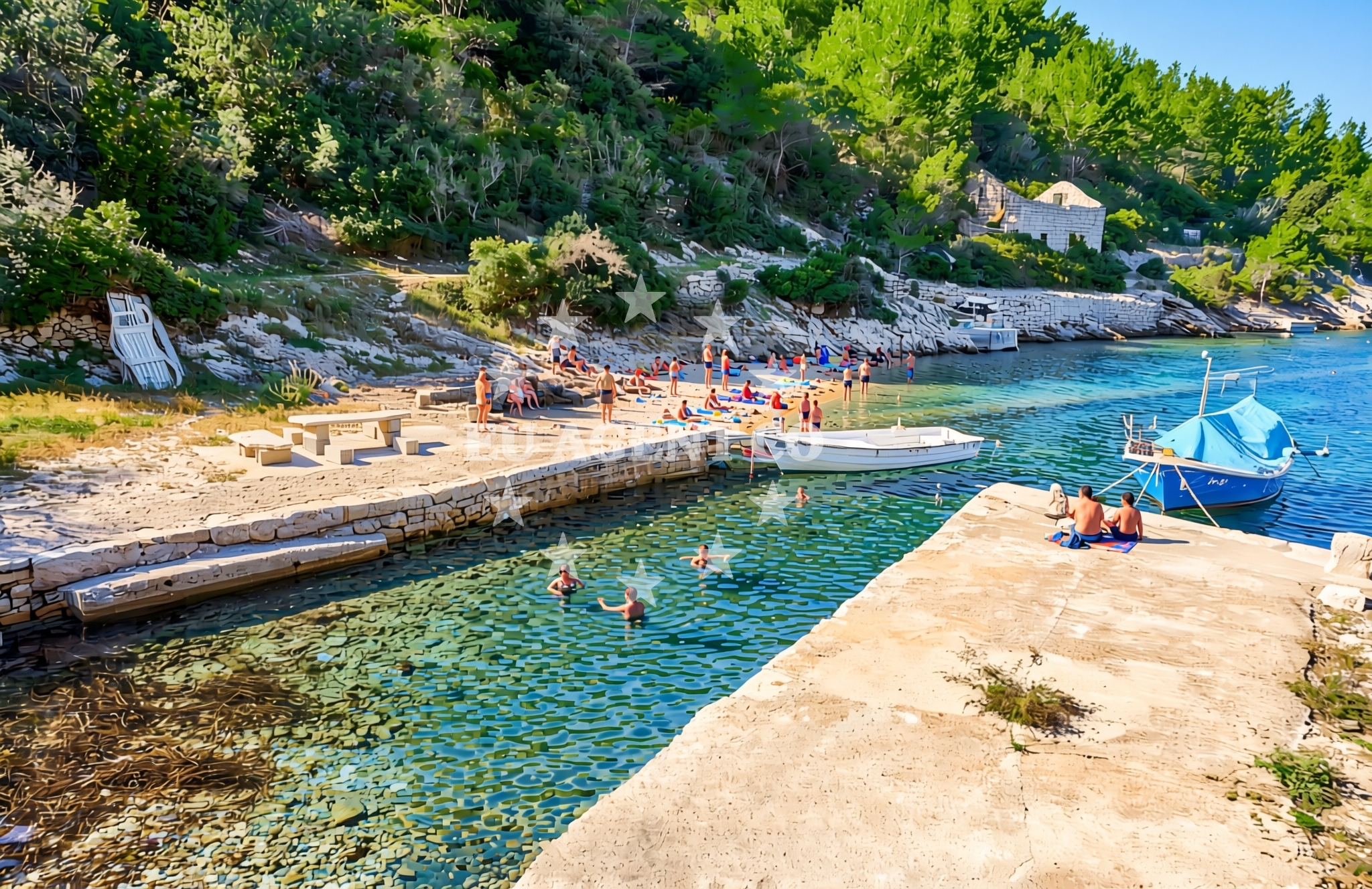
About this beach
Prapatna, Vela Luka (Korčula)
Beach: Prapatna
Location: Vela Luka (Korčula)
Characteristics and facilities
Concrete / stone slabs, rocks
Beach character
Prapatna's shoreline is composed primarily of concrete slabs and rocky outcrops, creating a rugged yet accessible environment. The beach lacks traditional sandy expanses but offers a unique setting for those seeking a more textured coastal experience. The rocky terrain may present challenges for swimming in certain areas but also provides opportunities for exploring tidal pools and natural formations. The beach's character aligns with the broader geological profile of Korčula's coastline, which features a mix of limestone cliffs and sheltered coves.Swimming and shore
Swimming conditions at Prapatna depend on the specific section of the beach. The rocky slabs and uneven shoreline create variable water access, with some areas offering shallow, calm waters suitable for wading. Deeper sections near the concrete slabs may be more turbulent. The shore itself is a mix of smooth stone surfaces and uneven rock formations, requiring caution when navigating. The beach's profile is typical of the Dalmatian coast's rocky inlets, which often require careful selection of entry points for water activities.Facilities and activities
No structured facilities or amenities are explicitly listed for Prapatna Beach. The absence of formal infrastructure means visitors should expect a natural, unspoiled environment. Activities are limited to passive enjoyment of the shoreline, with potential for rock exploration and coastal walking. The beach's characteristics make it less suited for organized water sports but offer a tranquil setting for those seeking solitude or a connection to the island's raw coastal landscapes.Access and location
Prapatna Beach is located within Vela Luka, a port town on Korčula's western coast. The island of Korčula, part of the Pelješac Peninsula, is renowned for its medieval architecture, vineyards, and strategic position along the Adriatic trade routes. Vela Luka itself serves as a gateway to the island's historic center, with ferry connections to nearby islands like Hvar and Brač. The beach's proximity to the town center and marina makes it a convenient stop for visitors exploring Korčula's coastal network.What to expect
Prapatna Beach presents a distinctive coastal profile with concrete slabs and rocky formations, diverging from the sandy beaches typical of the Dalmatian coast. The shoreline is best suited for visitors seeking a rugged, natural environment rather than a traditional beach experience. The lack of formal amenities means the beach remains unspoiled, with access limited to the rocky terrain. The area's connection to Vela Luka provides opportunities to explore the town's maritime heritage and nearby cultural sites on Korčula.Practical tips
Visitors should wear sturdy footwear to navigate the rocky terrain and consider bringing water for hydration, as shade options are limited. The beach's natural character means facilities like restrooms or showers are not available. Those arriving by yacht may find the nearby Vela Luka Marina a convenient base for exploring the area, with direct access to the beach and the island's historic sites.Exploring the coast by yacht
For yacht charter guests, Prapatna Beach offers a convenient vantage point to explore Korčula's coastline and surrounding Adriatic waters. The nearby Vela Luka Marina provides docking facilities for motor yachts and sailboats, serving as a hub for charters exploring the Pelješac Peninsula and nearby islands. The beach's proximity to the marina makes it an accessible stop for sailors seeking to combine coastal exploration with the island's cultural attractions. The Adriatic's clear waters and sheltered bays in this region make it a popular sailing destination, with routes extending to Hvar, Šipan, and the mainland coast.Korčula's Coastal Legacy
The island of Korčula, with its Venetian influences and medieval fortifications, offers a unique blend of history and natural beauty. The Pelješac Peninsula, where Korčula is situated, is known for its vineyards and the Strait of Pelješac, a key maritime passage connecting the Adriatic to the open sea. Yacht charter guests often combine visits to Prapatna Beach with explorations of Korčula Town's UNESCO-listed old town and the island's wine-producing regions.
Anchorages in the surrounding area
Anchorages in Vela Luka and Korčula are located near Prapatna Beach.
- Gradina — vela luka — korcula — 1.6 NM from beach
- Anchorage — vela luka — korcula — 3.0 NM from beach
- Anchorage — vela luka — korcula — 3.8 NM from beach
- Anchorage — vela luka — korcula — 3.9 NM from beach
- Anchorage — korcula — 3.9 NM from beach
- Anchorage — vela luka — korcula — 3.9 NM from beach
- Proizd — 4.0 NM from beach
- Anchorage — vela luka — korcula — 4.6 NM from beach
Distances are straight-line geographic distances, not sailing routes.
Mooring buoys in the surrounding area
Mooring buoys in Vela Luka and Korčula are situated close to Prapatna Beach.
- Buoy field — vela luka — korcula — 1.5 NM from beach
- Gradina buoy field — vela luka — korcula — 1.6 NM from beach
- Jetty — vela luka — korcula — 3.8 NM from beach
- Jetty — proizd — 3.9 NM from beach
- Quay — vela luka — korcula — 5.5 NM from beach
Distances are straight-line geographic distances, not sailing routes.
Marine fuel stations
- Ina — vela luka — korcula — 1.4 NM from beach
- Ina — vrboska — hvar — 11.8 NM from beach
- Ina — ubli — lastovo — 15.3 NM from beach
- Fuel station — hvar — 15.9 NM from beach
Distances are straight-line geographic distances, not sailing routes.
Harbours in the surrounding area
Harbours in Vela Luka and Korčula are positioned near Prapatna Beach.
- Vela Luka — korcula — 1.3 NM from beach
- Prigradica — korcula — 4.6 NM from beach
- Brna — korcula — 8.2 NM from beach
- Marina Bilo Idro — sveta nedjelja — hvar — 10.4 NM from beach
- Port Jelsa — hvar — 10.7 NM from beach
- Zavalatica — korcula — 10.8 NM from beach
Distances are straight-line geographic distances, not sailing routes.
Marinas in the surrounding area
Marinas in Vela Luka and surrounding regions are located near Prapatna Beach.
- Marina Korkyra — vela luka — korcula — 1.5 NM from beach
- ACI Marina Vrboska — hvar — 11.8 NM from beach
- Marina Solitudo — lastovo — 14.1 NM from beach
- ACI Marina Palmižana — aci marina palmizana — st klement — 17.4 NM from beach
- ACI Marina Korčula — korcula — 18.9 NM from beach
Distances are straight-line geographic distances, not sailing routes.
Restaurants near the beach
Restaurants in Vela Luka are situated near Prapatna Beach.
- Pizzeria Alfa — vela luka — korcula — 1.3 NM from beach
- Restoran More — vela luka — korcula — 1.3 NM from beach
- Konoba Skalinada — vela luka — korcula — 1.3 NM from beach
- Pod Bore — vela luka — korcula — 1.4 NM from beach
- Nautica — vela luka — korcula — 1.4 NM from beach
- Konoba Ribar — vela luka — korcula — 1.5 NM from beach
- Restaurant Luky — vela luka — korcula — 1.5 NM from beach
Distances are straight-line geographic distances, not sailing routes.
Navigation guides for the surrounding area
Navigation guides for Uvala Prihonja and other nearby areas are relevant to Prapatna Beach.
- Uvala Prihonja — 0.3 NM from beach
- Uvala Sveti Ivan (Uvala Gradina) — 1.5 NM from beach
- Uvala Poplat — 2.9 NM from beach
- Uvala Tri Luke — 3.9 NM from beach
- Luka Karbuni — 4.6 NM from beach
Distances are straight-line geographic distances, not sailing routes.
Yachts from nearby departure bases
Yachts departing from Makarska Port and Milna Marina Vlaška are located near Prapatna Beach.
Sailing yachts
- Bavaria 40 Cruiser (LADY BUTTERFLY) — Tučepi Port — 22.7 NM from departure base to beach
- Hanse 388 (BANJO) — Milna Marina Vlaška — 23.8 NM from departure base to beach
- Bavaria 46 Cruiser (MO) — Milna Marina Vlaška — 23.8 NM from departure base to beach
- Hanse 505 (AVALON) — Milna Marina Vlaška — 23.8 NM from departure base to beach
- Hanse 455 (AURUM 1) — Milna Marina Vlaška — 23.8 NM from departure base to beach
Motor yachts
- Princess V53 (Chablis) — Makarska Port — 22.9 NM from departure base to beach
Motor boats
- Jeanneau NC 37 (Black Pearl) — Makarska Port — 22.9 NM from departure base to beach
- Galeon 430 Skydeck (BELLAGIO) — Makarska Port — 22.9 NM from departure base to beach
- Jeanneau NC 37 (Black Pearl) — Makarska Port — 22.9 NM from departure base to beach
- Galeon 430 Skydeck (Bellagio) — Makarska Port — 22.9 NM from departure base to beach
Distances are straight-line geographic distances, not sailing routes.