Popova luka II Beach - Duboka, Croatia
Beach character
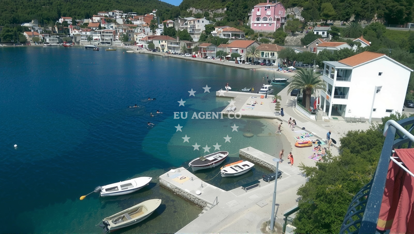
The beach's defining feature is its cove shape, measuring 290 meters in length and 10 meters in width. The shoreline is composed of small beige pebbles, a characteristic common to many Adriatic beaches where erosion has shaped the coast over centuries. Behind the beach, the landscape rises sharply into mountainous terrain, offering panoramic views of the surrounding area. The seabed near the shore is covered in silt, which may affect swimming comfort and is not ideal for activities requiring stable footing. Depth increases gradually, making it a moderate option for swimmers, though the muddy substrate may not appeal to all visitors.Swimming and shore
Swimming conditions at Popova luka II are influenced by the silt-covered seabed, which can make the water feel less clear and more textured than in some other Adriatic beaches. The moderate depth increase means the beach is accessible to swimmers of varying abilities, though the pebble shoreline may be uncomfortable for those with sensitive feet. The absence of structured amenities means visitors should bring their own towels, sunscreen, and water. The beach's orientation within the cove creates natural shelter from direct winds, though larger swells from the open sea may occasionally reach the shore.Facilities and activities
No formal facilities are reported at Popova luka II, aligning with the character of many lesser-developed Adriatic beaches. However, the beach is associated with motor boat rentals and general water entertainment, suggesting opportunities for short excursions along the coast. The lack of infrastructure means this is not a destination for those seeking showers, restrooms, or shaded seating. For visitors interested in exploration, the nearby mountainous backdrop and coastal positioning make it a potential starting point for hiking or kayaking trips along the Dubrovnik coastline.Access and location
Located in Duboka, a coastal village approximately 25 kilometers northeast of Cavtat and 35 kilometers from the historic city of Dubrovnik, Popova luka II sits within a region renowned for its medieval architecture and UNESCO-protected sites. The beach's proximity to the main road network makes it accessible by car, though parking details are not specified in official records. The surrounding area is part of the Neretva River Delta, a biodiverse region with wetlands, pine forests, and traditional fishing villages. This positioning places it within reach of both cultural landmarks and natural reserves, though the beach itself remains relatively secluded compared to more commercialized Adriatic destinations.What to expect
Visitors to Popova luka II should anticipate a natural, undeveloped shoreline featuring small beige pebbles and a silt-covered seabed. The beach's cove shape offers sheltered conditions, making it a potentially pleasant spot for casual swimming despite the textured underwater terrain. The surrounding mountains provide a dramatic backdrop, though the lack of amenities means this is not a destination for those seeking modern conveniences. The beach's association with motor boat rentals suggests it may serve as a launch point for short coastal excursions. Due to its location in Duboka, travelers may wish to combine a visit with explorations of nearby towns like Cavtat or the walled city of Dubrovnik, both within a short drive.Practical tips
Given the pebble shoreline, sturdy footwear is recommended for walking along the beach. The silt seabed may make swimming feel less buoyant, so visitors should be prepared for a different experience than clearer, sand-bottomed Adriatic beaches. As no facilities are reported, bringing personal items like towels and water is essential. The beach's position near the Neretva River Delta means it may be a good base for nature-focused activities, though those seeking more structured amenities should consider nearby settlements.Exploring the coast by yacht
For yacht charter guests, the Dubrovnik coastline—including areas near Popova luka II—offers a mix of sheltered bays and open sea routes. The region is part of the broader Adriatic sailing circuit, with marinas in Cavtat and Dubrovnik providing bases for exploring the area. While Popova luka II itself is not marked as an anchorage, its proximity to the main road network and the Neretva River Delta may make it a convenient stop for those traveling between coastal towns. Yacht charter companies operating in the region often highlight the area's historic sites, hidden coves, and opportunities for day trips to nearby islands like Mljet or Elafonissi.Regional Context and Travel Connections
The Dubrovnik-Neretva County, where Popova luka II is located, is a focal point for Adriatic tourism due to its blend of medieval heritage and natural beauty. The nearby town of Cavtat, a 15-minute drive away, features a long pebble beach and a historic Old Town with Venetian-era architecture. Further afield, the city of Dubrovnik—famous for its well-preserved walls and UNESCO World Heritage status—is approximately 35 kilometers southwest. The region's maritime history is evident in its numerous anchorages, with the nearby Bay of Kotor offering deeper waters for larger yachts. For those exploring by land, the Neretva River Delta is a protected area with opportunities for birdwatching and kayaking, though the beach itself remains a more isolated coastal spot.Anchorages in the surrounding area
Anchorages near Duboka, including Anchorage — duboka and Anchorage — klek.
- Anchorage — duboka — 0.1 NM from beach
- Anchorage — klek — 0.5 NM from beach
- Anchorage — klek — 0.9 NM from beach
- Anchorage — brijesta — 2.3 NM from beach
- Anchorage — duba — 3.0 NM from beach
- Anchorage — blace — 4.4 NM from beach
- Anchorage — zuljana — 5.1 NM from beach
- Anchorage — zuljana — 5.4 NM from beach
Distances are straight-line geographic distances, not sailing routes.
Mooring buoys in the surrounding area
Mooring buoys and jetties in the area, such as Brijesta and Jetty — blace.
- Brijesta — 2.3 NM from beach
- Jetty — blace — 4.4 NM from beach
- Quay — prapratno — 9.7 NM from beach
- Buoy — mljet — 11.3 NM from beach
- Restaurant Dalmatinac quay — mljet — 11.3 NM from beach
Distances are straight-line geographic distances, not sailing routes.
Marine fuel stations
Marine fuel stations located in Ploce, Mljet, Korcula, and Dubrovnik.
- Fuel station — ploce — 8.0 NM from beach
- Fuel station — sobra — mljet — 12.9 NM from beach
- Fuel station — korcula — 17.3 NM from beach
- Ina — dubrovnik — 29.2 NM from beach
Distances are straight-line geographic distances, not sailing routes.
Harbours in the surrounding area
Harbours in the surrounding area, including Drače, Sresar, and Opuzen.
- Drače — drace — 4.2 NM from beach
- Sresar — rat — 4.3 NM from beach
- Opuzen — 4.5 NM from beach
- Žuljana — zuljana — 5.1 NM from beach
- Trstenik — 6.5 NM from beach
- Ploče — ploce — 8.1 NM from beach
Distances are straight-line geographic distances, not sailing routes.
Marinas in the surrounding area
- Marina Lumbarda — korcula — 16.3 NM from beach
- ACI Marina Korčula — korcula — 17.9 NM from beach
- ACI Marina Slano — 18.1 NM from beach
- Marina Tučepi — marina tucepi — 28.6 NM from beach
- Marina Frapa Dubrovnik — 29.3 NM from beach
Distances are straight-line geographic distances, not sailing routes.
Navigation guides for the surrounding area
Navigation guides for nearby areas, including Uvala Klek and Uvala Kljemtine.
- Uvala Kljemtine — 0.8 NM from beach
- Uvala Klek — 1.0 NM from beach
- Uvala Lopata — 1.6 NM from beach
- Bl ace — 4.3 NM from beach
- Trstenik — 6.3 NM from beach
Distances are straight-line geographic distances, not sailing routes.
Yachts from nearby departure bases
Yachts departing from Ploče City Port and Slano ACI Marina, offering sail and catamaran options.
Sailing yachts
- Elan 40 Impression (Karleta) — Ploče City Port — 8.0 NM from departure base to beach
- Elan 514 Impression (Cesarica III) — Ploče City Port — 8.0 NM from departure base to beach
- Sun Odyssey 349 (Porto Tolero) — Ploče City Port — 8.0 NM from departure base to beach
- More 55 (MRS. ROBINSON) — Ploče City Port — 8.0 NM from departure base to beach
- Salona 44 (SAMOA) — Ploče City Port — 8.0 NM from departure base to beach
- Sun Odyssey 419 (Luka Ploce) — Ploče City Port — 8.0 NM from departure base to beach
- Sun Odyssey 349 (Visnjica) — Ploče City Port — 8.0 NM from departure base to beach
- Oceanis 45 (Soul) — Slano ACI Marina — 18.1 NM from departure base to beach
Catamarans
- Lagoon 450 Fly (Alba Mouse) — Ploče City Port — 8.0 NM from departure base to beach
- Lagoon 450 Flybridge (MALA MARE) — Slano ACI Marina — 18.1 NM from departure base to beach
Distances are straight-line geographic distances, not sailing routes.