Pomišalj, Kruševo (Obrovac) Beach, Croatia
About this beach
Pomišalj, Kruševo (Obrovac)
Beach: Pomišalj
Location: Kruševo (Obrovac)
Characteristics and facilities
Gravel, concrete / stone slabs
80 m
Caffe bar / Drinks stand
Natural shade
Beach character
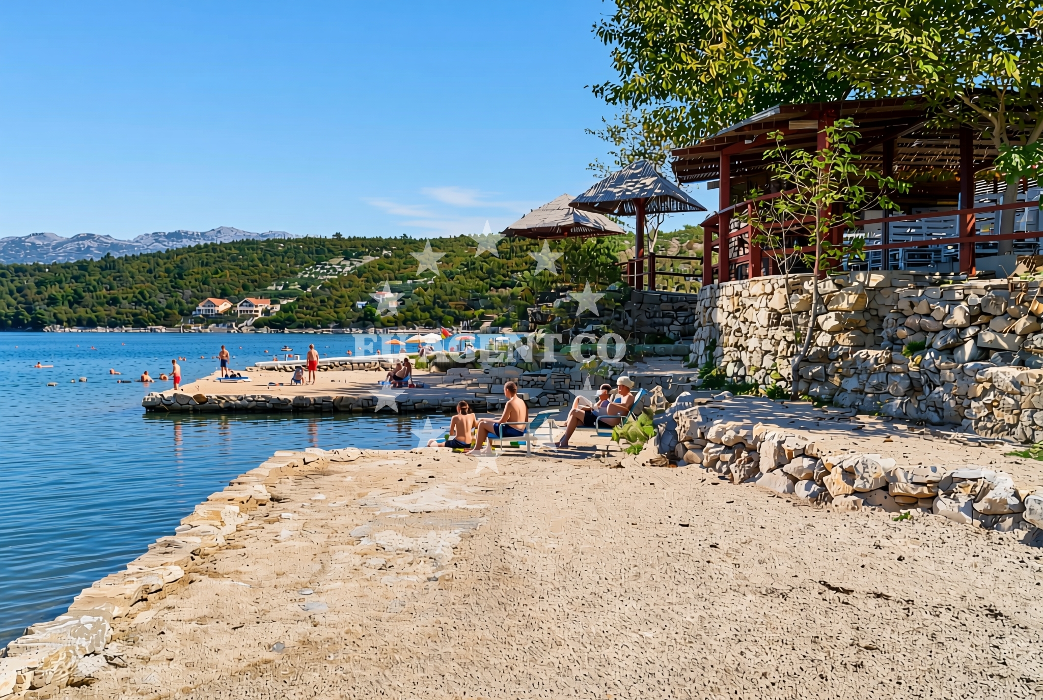
The beach consists of gravel and stone slabs, creating a firm surface ideal for walking but less suited for sunbathing. Its 80-meter length provides a modest shoreline, with the caffe bar serving as the primary on-site facility. Natural shade is available from nearby trees or rocky outcrops, offering respite from the sun. The beach's character reflects the rugged coastal terrain typical of this region, where development is minimal and natural features dominate.Swimming and shore
Swimming is possible along the shoreline, though the gravel and stone composition may make it less comfortable for prolonged periods. The beach's short length means it is best suited for brief dips or as a stopover during longer coastal excursions. The shore itself is composed of compacted gravel and stone slabs, which can be uneven underfoot but provide stable access to the water.Facilities and activities
The beach's main facility is a caffe bar/drinks stand, offering basic refreshments for visitors. No other amenities such as showers, restrooms, or changing rooms are listed in the beach's authoritative records. Activities are limited to passive enjoyment of the shoreline, with no structured recreational options reported. The absence of formal facilities aligns with the beach's low-key character and the broader trend of undeveloped shorelines in this part of Croatia.Access and location
Pomišalj Beach is situated in Kruševo, a small settlement on the Brod region's northern coast. Access is likely via local roads connecting to the village, though specific parking details are not documented. The beach's location places it near the Brod River's mouth, where the Adriatic Sea meets inland waterways. This positioning makes it a potential waypoint for inland travelers seeking coastal access, though it is not a major destination for large-scale tourism.What to expect
Expect a straightforward shoreline experience at Pomišalj Beach, characterized by gravel and stone slabs rather than sand. The caffe bar provides a place to purchase drinks, though no other services are available. Natural shade is present, offering limited relief from direct sunlight. The beach's compact size and lack of formal amenities make it more suitable as a brief stop than an extended visit. Its location near the Brod River's mouth may appeal to those interested in the region's inland-out coast transitions.Practical tips
Given the gravel and stone surface, wear sturdy footwear for walking along the shore. The caffe bar's operating hours are not specified, so arrive early if refreshments are a priority. The beach's proximity to the Brod River may make it an interesting spot for those combining inland and coastal exploration, though no specific routes or transportation links are documented.Exploring the coast by yacht
For yacht charter guests exploring the northern Adriatic, Pomišalj Beach lies within reach of Brod's coastal waters. While not a major anchorage point, its location near the Brod River's mouth could serve as a reference point for sailors navigating between inland waterways and the open sea. Euro-Agent's yacht charter services can help plan routes through this region, connecting to larger coastal hubs like Zadar or Split further south.Regional Context: Brod's Coastal Identity
The Brod region's coastline is defined by a mix of natural shorelines and limited development, reflecting its historical role as a transportation corridor between inland Croatia and the Adriatic. Pomišalj Beach exemplifies this character, with its simple facilities and proximity to the Brod River. The area's appeal lies in its accessibility for inland travelers and its role as a transitional zone between riverine and maritime environments.Anchorages in the surrounding area
Anchorages near Pomišalj, Kruševo (Obrovac) Beach include Novigrad, Maslenica, and Karin, offering nearby mooring options.
- Anchorage — novigrad — 0.1 NM from beach
- Anchorage — maslenica — 1.9 NM from beach
- Anchorage — karin — 2.7 NM from beach
- Karin dock — 3.0 NM from beach
- Anchorage — vinjerac — 7.5 NM from beach
- Anchorage — ljubac — 13.7 NM from beach
- Anchorage — ljubac — 13.9 NM from beach
- Anchorage — rtina — 14.4 NM from beach
Distances are straight-line geographic distances, not sailing routes.
Mooring buoys in the surrounding area
Mooring buoys near Pomišalj, Kruševo (Obrovac) Beach include Ljubac Jetty and Sibuljina Point, providing additional anchoring points in the vicinity.
- Jetty — ljubac — 14.1 NM from beach
- Šibuljina Point — sibuljina point — 14.6 NM from beach
Distances are straight-line geographic distances, not sailing routes.
Marine fuel stations
Marine fuel stations near Pomišalj, Kruševo (Obrovac) Beach are located in Sukosan, Biograd na Moru, Zadar, and Preko, ensuring refueling options along the route.
- Fuel station — sukosan — 15.3 NM from beach
- Ina — biograd na moru — 16.3 NM from beach
- Ina — zadar — 16.6 NM from beach
- Ina — preko — ugljan — 18.7 NM from beach
Distances are straight-line geographic distances, not sailing routes.
Harbours in the surrounding area
Harbours near Pomišalj, Kruševo (Obrovac) Beach include Obrovac, Maslenica, and Vinjerac, offering nearby port facilities.
- Maslenica — 3.5 NM from beach
- Obrovac — 3.7 NM from beach
- Vinjerac — 7.5 NM from beach
- Seline — 7.8 NM from beach
- Starigrad Paklenica — 9.7 NM from beach
- Ražanac — razanac — 12.5 NM from beach
Distances are straight-line geographic distances, not sailing routes.
Marinas in the surrounding area
- Dry dock marina Biograd — biograd na moru — 15.1 NM from beach
- Marina Dalmacija — sukosan — 15.1 NM from beach
- Molum Marine Club — sveti filip i jakov — 15.5 NM from beach
- Marina Kornati — biograd na moru — 16.1 NM from beach
- Marina Šangulin — marina sangulin — biograd na moru — 16.1 NM from beach
Distances are straight-line geographic distances, not sailing routes.
Navigation guides for the surrounding area
Navigation guides for the surrounding area of Pomišalj, Kruševo (Obrovac) Beach include Posedarje (Novigradsko More), aiding in route planning nearby.
- Posedarje (Novigradsko More) — 5.5 NM from beach
- Starigrad-Paklenica {Velebitski Kanai) — 9.5 NM from beach
- VELESITSKI KANAL (S) — 13.1 NM from beach
Distances are straight-line geographic distances, not sailing routes.
Yachts from nearby departure bases
Sailing yachts
- Bavaria 33 Cruiser (MARA) — Sukošan Marina Dalmacija — 15.1 NM from departure base to beach
Catamarans
- Lagoon 51 (APOLON) — Sukošan Marina Dalmacija — 15.1 NM from departure base to beach
Motor yachts
- Azimut 72 (Relax of Croatia) — Sukošan Marina Dalmacija — 15.1 NM from departure base to beach
Motor boats
- Merry Fisher 795 () — Novigrad Dalmatia — 2.4 NM from departure base to beach
- Merry Fisher 695 — Sukošan Brodogradilište Filipi — 14.9 NM from departure base to beach
- Zar 61 Suite (Tucepi) — Sukošan Brodogradilište Filipi — 14.9 NM from departure base to beach
- Quicksilver Activ 555 — Sukošan Brodogradilište Filipi — 14.9 NM from departure base to beach
- Elan 650 (Biokovo) — Sukošan Brodogradilište Filipi — 14.9 NM from departure base to beach
- Zar 65 Suite — Sukošan Brodogradilište Filipi — 14.9 NM from departure base to beach
- Zar 57 WD — Sukošan Brodogradilište Filipi — 14.9 NM from departure base to beach
Distances are straight-line geographic distances, not sailing routes.