Plaza Gabrica Beach, Croatia
Plaza Gabrica lies on the Pelješac Peninsula's eastern coast, a 30-meter-long cove beach formed by small beige pebbles. The beach's shallow, gradually deepening waters create a natural safety buffer for children and non-swimmers, while the surrounding mountains provide consistent shade throughout the day. Located in Vela Luka, this beach connects to the broader Adriatic sailing network that includes Korčula and the Dubrovnik coast.
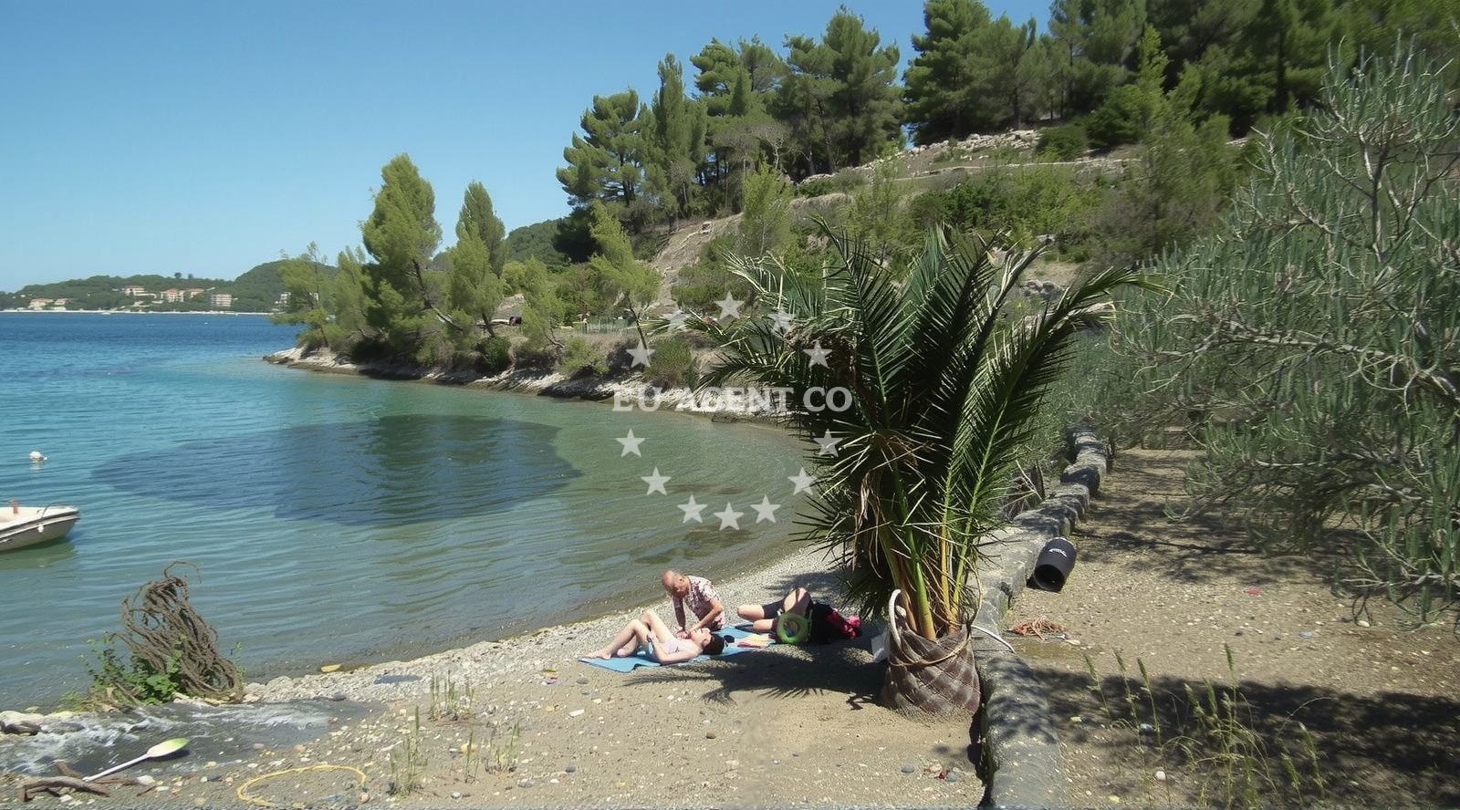
Beach character
The beach's defining feature is its pebble composition, with small beige stones covering most of the shore. The cove's dimensions (30m x 10m) create a sheltered environment, though the sea floor remains composed of similar pebbles. Depth increases very smoothly, making it one of the few beaches in the region where young swimmers can progress safely from shallow to deeper waters. The mountainous backdrop to the north provides natural shade, though the beach lacks artificial sun protection facilities.
Swimming and shore
The water depth increases gradually, suitable for children and non-swimmers. While the pebble surface is firm, it may be uncomfortable for those with sensitive feet. The beach lacks designated swimming zones or lifeguard services. Divers should note the pebble substrate may affect underwater visibility compared to sandy beaches in the region.
Facilities and activities
No official amenities are listed for Plaza Gabrica. The beach is primarily accessed via the nearby settlement of Vela Luka, which offers broader tourism infrastructure. Available activities include diving and water entertainment, though no rental equipment or guided tours are explicitly associated with the beach itself. The surrounding Pelješac Peninsula is known for sailing, with several marinas within 15 nautical miles.
Access and location
Plaza Gabrica is located in Vela Luka, a coastal town on the Pelješac Peninsula. The beach is approximately 12 kilometers from the town center of Vela Luka and 35 kilometers from the island of Korčula. The region is a key point on the Adriatic sailing route connecting Dubrovnik to the Dalmatian islands. The beach's coordinates (42.95691, 16.69527) place it within the broader sailing area that includes the Bay of Komiža and the channels between the Pelješac Peninsula and the mainland.
What to expect
Expect a pebble beach with smooth depth gradients ideal for family swimming. The beach lacks artificial facilities but benefits from natural shade provided by surrounding mountains. Divers and water sports enthusiasts will find opportunities for activity, though no equipment rentals are listed. The beach's cleanliness index is reported as very poor, suggesting visitors should bring personal towels and water containers. The moderate crowd level in high season aligns with Vela Luka's overall tourism pattern.
Practical tips
Consider bringing water shoes for comfort on the pebble surface. The beach's poor cleanliness rating suggests using waterproof bags for valuables. Early arrival may help avoid crowds during peak season. The smooth depth progression makes it suitable for teaching children to swim, but lifeguards are not present.
Exploring the coast by yacht
The Pelješac Peninsula is a key sailing region with several marinas within 15 nautical miles, including Vela Luka Marina and Korčula Town Marina. Yacht charter guests exploring the Adriatic often include this area in itineraries that connect Dubrovnik to the Dalmatian islands. While Plaza Gabrica itself is not an anchorage, the nearby waters are part of the sailing routes that include the Bay of Komiža and the channels between the peninsula and the mainland.
Regional Context and Connectivity
Vela Luka serves as a gateway to the Pelješac Peninsula, with ferry connections to the mainland and boat tours to nearby islands. The town's marina accommodates both sailing yachts and motor boats, making it a common base for Adriatic cruises. The beach's location near the peninsula's eastern tip offers views of the island of Šipan and the broader Adriatic coastline.
Anchorages in the surrounding area
Anchorages in Vela Luka offer nearby options for mooring within a few nautical miles of Plaza Gabrica.
- Gradina — vela luka — korcula — 1.3 NM from beach
- Anchorage — vela luka — korcula — 1.4 NM from beach
- Anchorage — vela luka — korcula — 2.1 NM from beach
- Anchorage — vela luka — korcula — 2.1 NM from beach
- Anchorage — vela luka — korcula — 2.2 NM from beach
- Anchorage — korcula — 2.3 NM from beach
- Anchorage — vela luka — korcula — 2.8 NM from beach
- Pržnjak Veli and Mali — prznjak veli and mali — 3.1 NM from beach
Distances are straight-line geographic distances, not sailing routes.
Mooring buoys in the surrounding area
- Buoy field — vela luka — korcula — 0.8 NM from beach
- Gradina buoy field — vela luka — korcula — 1.3 NM from beach
- Jetty — vela luka — korcula — 2.1 NM from beach
- Jetty — proizd — 3.7 NM from beach
- Quay — vela luka — korcula — 4.6 NM from beach
Distances are straight-line geographic distances, not sailing routes.
Marine fuel stations
- Ina — vela luka — korcula — 0.9 NM from beach
- Ina — vrboska — hvar — 13.4 NM from beach
- Ina — ubli — lastovo — 14.0 NM from beach
- Fuel station — hvar — 16.7 NM from beach
Distances are straight-line geographic distances, not sailing routes.
Harbours in the surrounding area
- Vela Luka — korcula — 1.0 NM from beach
- Prigradica — korcula — 5.1 NM from beach
- Brna — korcula — 7.9 NM from beach
- Zavalatica — korcula — 10.9 NM from beach
- Marina Bilo Idro — sveta nedjelja — hvar — 11.7 NM from beach
- Port Jelsa — hvar — 12.3 NM from beach
Distances are straight-line geographic distances, not sailing routes.
Marinas in the surrounding area
- Marina Korkyra — vela luka — korcula — 0.8 NM from beach
- Marina Solitudo — lastovo — 12.8 NM from beach
- ACI Marina Vrboska — hvar — 13.4 NM from beach
- ACI Marina Palmižana — aci marina palmizana — st klement — 18.1 NM from beach
- ACI Marina Korčula — korcula — 19.4 NM from beach
Distances are straight-line geographic distances, not sailing routes.
Restaurants near the beach
- Restaurant Luky — vela luka — korcula — 0.8 NM from beach
- Konoba Ribar — vela luka — korcula — 0.9 NM from beach
- Restoran More — vela luka — korcula — 1.0 NM from beach
- Konoba Lucica — vela luka — korcula — 1.0 NM from beach
- Konoba Bata — vela luka — korcula — 1.0 NM from beach
- Konoba Bata — vela luka — korcula — 1.0 NM from beach
- Nautica — vela luka — korcula — 1.0 NM from beach
Distances are straight-line geographic distances, not sailing routes.
Navigation guides for the surrounding area
Navigation guides for nearby areas like Uvala Sveti Ivan assist in planning routes around Plaza Gabrica.
- Uvala Sveti Ivan (Uvala Gradina) — 1.2 NM from beach
- Uvala Poplat — 1.3 NM from beach
- Uvala Prihonja — 1.9 NM from beach
- Uvala Tri Luke — 2.2 NM from beach
- Luka Karbuni — 3.3 NM from beach
Distances are straight-line geographic distances, not sailing routes.
Yachts from nearby departure bases
Sailing yachts
- Bavaria 40 Cruiser (LADY BUTTERFLY) — Tučepi Port — 24.3 NM from departure base to beach
- Bavaria 46 Cruiser (MO) — Milna Marina Vlaška — 25.0 NM from departure base to beach
- Hanse 455 (AURUM 1) — Milna Marina Vlaška — 25.0 NM from departure base to beach
- Hanse 505 (AVALON) — Milna Marina Vlaška — 25.0 NM from departure base to beach
- Hanse 388 (BANJO) — Milna Marina Vlaška — 25.0 NM from departure base to beach
Motor yachts
- Princess V53 (Chablis) — Makarska Port — 24.6 NM from departure base to beach
Motor boats
- Galeon 430 Skydeck (BELLAGIO) — Makarska Port — 24.6 NM from departure base to beach
- Jeanneau NC 37 (Black Pearl) — Makarska Port — 24.6 NM from departure base to beach
- Galeon 430 Skydeck (Bellagio) — Makarska Port — 24.6 NM from departure base to beach
- Jeanneau NC 37 (Black Pearl) — Makarska Port — 24.6 NM from departure base to beach
Distances are straight-line geographic distances, not sailing routes.