Plat istok, Zubovići (Pag) Beach, Croatia
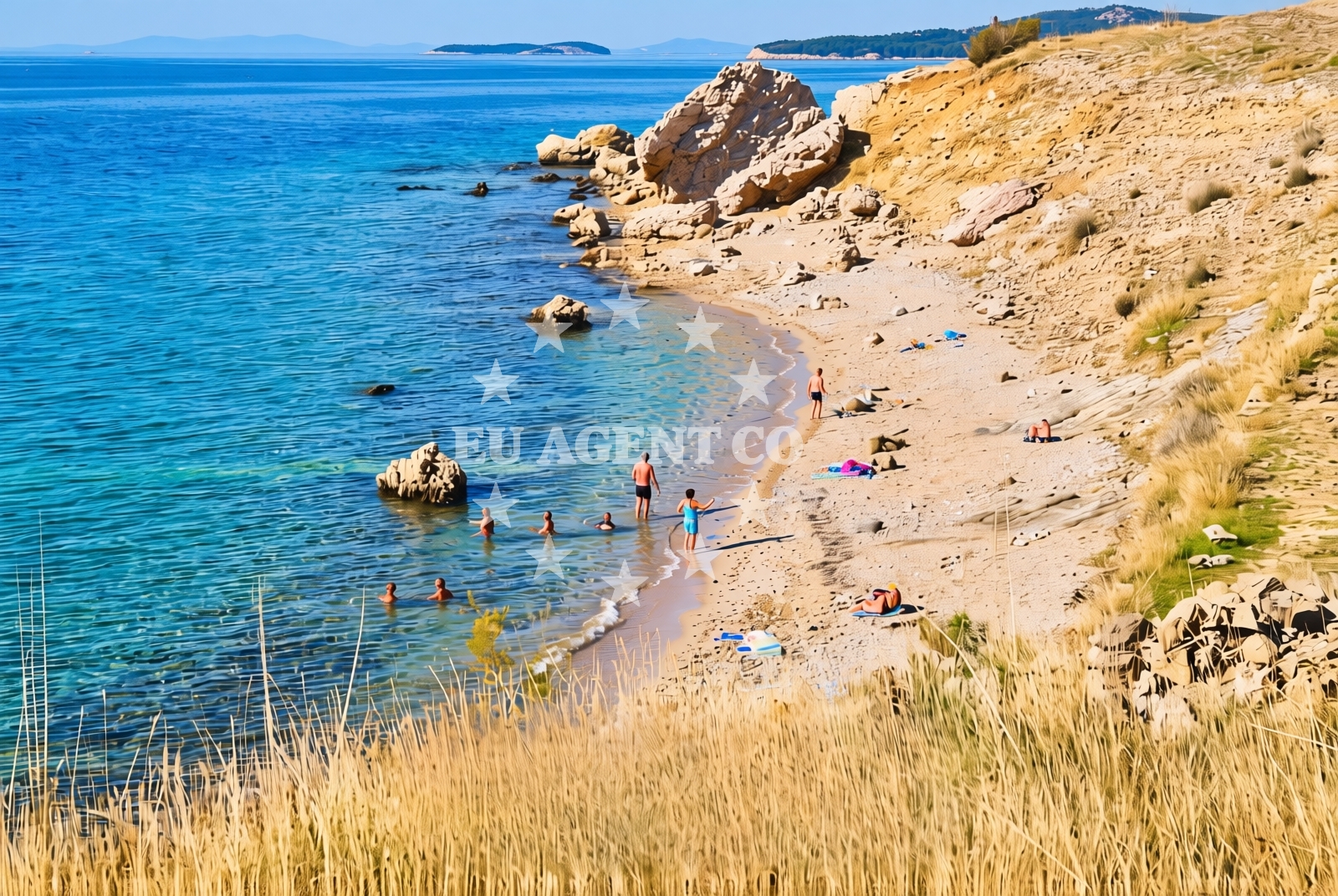
Plat istok Beach, located in the village of Zubovići on the island of Pag, stretches along a 250-meter shoreline characterized by gravel and rocky terrain. This secluded stretch of coast lies on the northern edge of Pag, a windswept island known for its dramatic cliffs, salt pans, and unspoiled natural landscapes. The beach's composition makes it a distinct alternative to the island's more common pebble and sand beaches, offering visitors a rugged coastal experience that reflects Pag's geological character.
About this beach
Plat istok, Zubovići (Pag)
Beach: Plat istok
Location: Zubovići (Pag)
Characteristics and facilities
Gravel, rocks
250 m
Beach character
The beach's gravel and rock surface creates a unique environment for visitors. While not ideal for sunbathing, the terrain offers opportunities for exploring tide pools and rocky inlets, particularly during low tide. The shoreline's composition suggests it may be more suited for those seeking a quiet, less crowded spot rather than a traditional beach experience. Pag's coastal geography, with its limestone formations and sparse vegetation, contributes to the beach's stark yet scenic appearance.
Swimming and shore
Swimming conditions at Plat istok depend on tide levels and wave activity. The rocky shoreline may limit safe swimming areas during high tide, though shallow waters near the gravel sections could offer calmer conditions. The beach's position on Pag's northern coast means it is exposed to the Adriatic's open waters, which can be rough during strong winds. Visitors should exercise caution near the rocky sections, as the terrain may be slippery when wet.
Facilities and activities
No specific facilities are listed for Plat istok Beach itself. As a lesser-known stretch of Pag's coastline, it likely lacks direct amenities such as showers, restrooms, or parking. However, the broader area of Zubovići and Pag offers cultural attractions, including traditional stone houses, local seafood restaurants, and the island's famed salt production heritage. Nearby, the village of Nošpara on Pag's eastern coast provides more developed amenities for visitors.
Access and location
Plat istok Beach is situated on the northern coast of Pag, near the village of Zubovići. The island of Pag, part of the Zadar County in Croatia, is accessible by ferry from Zadar, the nearest major city on the mainland. The beach's remote location suggests it may be reached via local roads within Zubovići, though specific access details are not documented in available resources. Pag's lack of motorized vehicles means the beach is likely accessible only on foot or by bicycle, aligning with the island's car-free policy.
What to expect
Visitors to Plat istok Beach should expect a rugged, gravelly shoreline that contrasts with Pag's more common pebble beaches. The beach's 250-meter length offers a secluded setting, though its rocky terrain may limit traditional beach activities. The area's natural character means there are no formal facilities, but the surrounding region of Pag provides cultural and historical interest, including salt pans, ancient ruins, and coastal trails. The beach's position on Pag's northern coast means it is exposed to the Adriatic's open waters, which can influence swimming conditions and weather patterns.
Practical tips
Given the beach's gravel and rock composition, visitors may want to wear sturdy footwear for exploring the shoreline. The lack of direct amenities suggests bringing personal supplies for comfort. Due to Pag's car-free policy, arriving by bicycle or on foot is recommended. Checking local tide times could help identify safer swimming areas during low tide.
Exploring the coast by yacht
For yacht charter guests exploring the Adriatic, Plat istok Beach offers a remote vantage point of Pag's northern coastline. The island's sheltered bays and open waters make it a popular sailing destination, with nearby anchorages in places like Nošpara and the island's eastern coast. While Plat istok itself is not a formal marina or anchorage, its proximity to Pag's sailing routes could make it a useful reference point for charters navigating the area. The Adriatic's clear waters and consistent winds make this region ideal for motor yacht and sailing yacht excursions.
Pag Island's Natural Features
Pag is one of Croatia's most distinctive islands, known for its karst landscape, salt pans, and lack of trees. The island's geology has shaped its coastline, creating dramatic cliffs and shallow bays. The salt pans, a UNESCO Biosphere Reserve, are a major attraction, though they are located farther from Plat istok. The island's car-free policy preserves its natural character, making it a unique destination for eco-conscious travelers.
Anchorages in the surrounding area
Anchorages in Cesarica and Mandre on Pag offer nearby options for mooring.
- Anchorage — cesarica — 2.8 NM from beach
- Anchorage — cesarica — 2.9 NM from beach
- Anchorage — cesarica — 3.1 NM from beach
- Anchorage — novalja — pag — 3.4 NM from beach
- Anchorage — mandre — pag — 3.4 NM from beach
- Anchorage — mandre — pag — 3.4 NM from beach
- Anchorage — mandre — pag — 3.8 NM from beach
- Anchorage — prizna — 4.7 NM from beach
Distances are straight-line geographic distances, not sailing routes.
Mooring buoys in the surrounding area
- Jetty — zubovici — pag — 0.3 NM from beach
- Jetty — zubovici — pag — 0.6 NM from beach
- Jetty — simuni — pag — 3.7 NM from beach
- Buoy field — novalja — pag — 5.4 NM from beach
- Drljanda — stara novalja — pag — 7.1 NM from beach
Distances are straight-line geographic distances, not sailing routes.
Marine fuel stations
- Ina — rab — 17.3 NM from beach
- Ina — mali losinj — 22.6 NM from beach
- Adria Oil — mali losinj — 22.9 NM from beach
- Ina — zadar — 26.2 NM from beach
Distances are straight-line geographic distances, not sailing routes.
Harbours in the surrounding area
Harbors in Zigljen and Novalja on Pag are nearby, while others are further afield.
- Karlobag — 3.5 NM from beach
- Žigljen — zigljen — pag — 4.0 NM from beach
- Prizna — 5.0 NM from beach
- Pag — 5.2 NM from beach
- Novalja — pag — 5.3 NM from beach
- Stara Novalja — pag — 6.7 NM from beach
Distances are straight-line geographic distances, not sailing routes.
Marinas in the surrounding area
- ACI Marina Šimuni — simuni — pag — 3.4 NM from beach
- ACI Marina Rab — 17.2 NM from beach
- ACI Marina Supetarska Draga — rab — 20.4 NM from beach
- Y/C Marina Mali Lošinj — mali losinj — 22.7 NM from beach
- Marina Lošinj — mali losinj — 22.9 NM from beach
Distances are straight-line geographic distances, not sailing routes.
Restaurants near the beach
Restaurants in Simuni and Novalja, Pag are close to the beach, offering nearby dining options.
- Maestral — simuni — pag — 3.3 NM from beach
- Bistro Šimuni — simuni — pag — 3.3 NM from beach
- Ribarska Koliba Šimuni — simuni — pag — 3.4 NM from beach
- Didova Kuča — simuni — pag — 3.4 NM from beach
- Pizzeria Villa Olea — simuni — pag — 3.4 NM from beach
- Margarita — novalja — pag — 4.7 NM from beach
- Restaurant — novalja — pag — 4.8 NM from beach
Distances are straight-line geographic distances, not sailing routes.
Navigation guides for the surrounding area
Navigation guides for Caska and Novalja provide route information in the surrounding area.
- Caska — 3.2 NM from beach
- Novalja — 4.9 NM from beach
- Uvala Prizna — 4.9 NM from beach
- Uvala Bliznica — 6.9 NM from beach
- Uvala Zavratnica — 11.4 NM from beach
Distances are straight-line geographic distances, not sailing routes.
Yachts from nearby departure bases
Sailing yachts
- First 45 (Egeria) — Šimuni Kolan ACI Marina — 3.3 NM from departure base to beach
- First 31.7 (Ruta) — Mali Lošinj — 22.7 NM from departure base to beach
- Elan 45 Impression (Jackpot) — Mali Lošinj — 22.7 NM from departure base to beach
Motor yachts
- Absolute 50 Fly (Acrobat) — Rab ACI Marina — 17.2 NM from departure base to beach
Motor boats
- Balt 818 Titanium (Valentina) — Novalja — 5.1 NM from departure base to beach
- Balt 818 Titanium (Valentina 2) — Novalja — 5.1 NM from departure base to beach
- BWA Sport 22GT (BWA ) — Pag City Port — 5.3 NM from departure base to beach
- Merry Fisher 895 — Povljana Marina — 11.5 NM from departure base to beach
- Merry Fisher 895 (Zablace) — Mali Lošinj — 22.7 NM from departure base to beach
- Atlantic Sun Cruiser 730 — Mali Lošinj — 22.7 NM from departure base to beach
Distances are straight-line geographic distances, not sailing routes.