Mirće sjever, Lovište Beach, Croatia
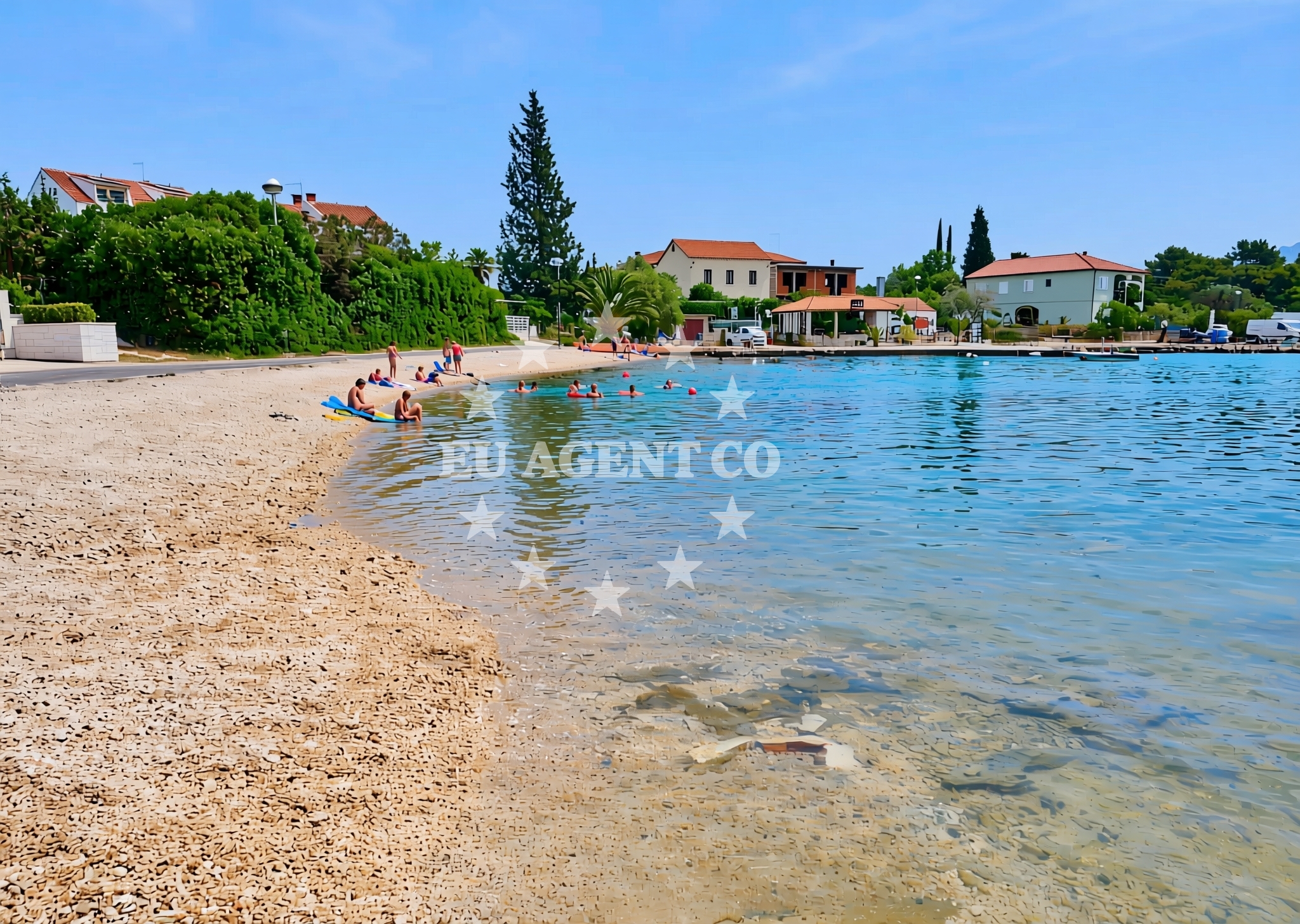
About this beach
Mirće sjever, Lovište
Beach: Mirće sjever
Location: Lovište
Characteristics and facilities
Gravel, concrete / stone slabs
120 m
Restaurant / snack bar
Caffe bar / Drinks stand
Beach character
The beach's surface consists of gravel and concrete slabs, a characteristic that reflects its utilitarian design. This composition suggests a focus on accessibility rather than leisurely relaxation, making it suitable for those prioritizing ease of movement over traditional sandy shorelines. The beach's length of 120 meters offers a modest stretch for sunbathing or brief walks, though it does not extend into the more expansive beaches typical of the region. Its positioning within Lovište, a smaller coastal settlement, means it is less likely to be crowded compared to larger Adriatic resorts.Swimming and shore
Swimming conditions at Mirće sjever are not explicitly detailed in available records, but the Adriatic's general reputation for clear waters and moderate currents applies here. The shoreline's gravel and concrete nature may make wading less comfortable than sandy beaches, though the beach's proximity to Lovište's harbor could provide alternative water access points. The immediate presence of a restaurant and caffe bar indicates that the beach is integrated into local infrastructure, potentially serving as a stop for those combining coastal visits with nearby maritime activities.Facilities and activities
Direct facilities at the beach include a restaurant and a caffe bar, both of which are positioned to serve visitors immediately. These amenities suggest a focus on convenience rather than extensive recreational offerings. No structured activities such as water sports or guided tours are listed, aligning with the beach's practical orientation. The absence of formal amenities like showers, parking, or lifeguard services implies that the beach functions more as a transitional or utilitarian space rather than a destination for extended leisure.Access and location
Mirće sjever is located within Lovište, a coastal settlement in Šibenik-Knin County, Croatia. The beach's coordinates (43.031156, 17.028995) place it near the central Dalmatian coast, a region known for its historical sites and maritime routes. Lovište itself is a smaller community with limited tourism infrastructure, meaning the beach is less likely to be a primary destination for international visitors. Access to the beach is likely via local roads, though specific parking details are not documented. Its proximity to the Adriatic's main sailing routes may make it a reference point for yachts navigating the area.What to expect
Mirće sjever, Lovište Beach is a straightforward coastal spot with a gravel and concrete shoreline, ideal for those seeking minimalistic access to the Adriatic. The beach's 120-meter length provides a modest space for sunbathing or casual walks, though it lacks the expansive features of larger resorts. A restaurant and caffe bar are available on-site, offering immediate refreshments without the need for travel. The beach's integration into Lovište's infrastructure suggests it is more of a functional coastal access point than a destination for leisure. Visitors should expect a utilitarian experience rather than a resort-like environment, with no formal amenities beyond the listed dining options.Practical tips
Visitors should note the beach's gravel and concrete surface, which may affect comfort during extended stays. The presence of a restaurant and caffe bar means food and drinks are readily available, though options may be limited to local fare. Due to the beach's modest size, it is advisable to arrive early if seeking a quiet spot. The area's proximity to Lovište's harbor could be useful for those combining a beach visit with maritime excursions.Exploring the coast by yacht
The Lovište area, including Mirće sjever, lies within a section of the Adriatic coast popular with yacht charter operators. The region's proximity to Šibenik and Knin offers access to historical sites, while its coastal inlets and bays provide opportunities for anchoring or mooring. Yacht charter guests exploring the Dalmatian coast may find the area useful as a reference point, though specific marinas or anchorages near Mirće sjever are not detailed in available records. For detailed sailing route information or marina availability, visitors are encouraged to consult the Euro-Agent Yacht Search page.Regional Context
Lovište is part of Šibenik-Knin County, a region with a mix of coastal and inland settlements. The area is known for its medieval fortifications, including the nearby Knin Fortress, and its role in Croatian history. The Dalmatian coast, where Lovište is located, is a major sailing destination, with routes extending to islands such as Šolta, Hvar, and Brač. While Mirće sjever itself is not a major maritime hub, its position along the coast makes it a potential stop for yachts traveling between mainland Croatia and the islands.Anchorages in the surrounding area
Anchorages in the surrounding area include multiple options in Lovište and nearby locations such as Racisce and Korcula.
- Lovišta — lovista — loviste — 0.2 NM from beach
- Anchorage — loviste — 0.4 NM from beach
- Anchorage — loviste — 0.5 NM from beach
- Anchorage — loviste — 0.7 NM from beach
- Anchorage — loviste — 0.9 NM from beach
- Anchorage — loviste — 1.5 NM from beach
- Anchorage — loviste — 1.8 NM from beach
- Anchorage — racisce — korcula — 3.3 NM from beach
Distances are straight-line geographic distances, not sailing routes.
Mooring buoys in the surrounding area
- Restaurant Korkyra xyz buoys — loviste — 0.3 NM from beach
- Jetty — loviste — 0.5 NM from beach
- Jetty — loviste — 1.6 NM from beach
- Konoba Estravaganca buoys - Duba — konoba estravaganca buoys duba — loviste — 1.8 NM from beach
- Jetty — korcula — 5.6 NM from beach
Distances are straight-line geographic distances, not sailing routes.
Marine fuel stations
Marine fuel stations are located in Korcula and other regions, with some situated further away in Makarska and Brac.
- Fuel station — korcula — 7.0 NM from beach
- Ina — vela luka — korcula — 14.4 NM from beach
- Ina — makarska — 15.8 NM from beach
- Fuel station — sumartin — brac — 17.0 NM from beach
Distances are straight-line geographic distances, not sailing routes.
Harbours in the surrounding area
Harbours in the surrounding area include Lovište and additional ports in Korcula, Viganj, and Duba Peljeska.
- Lovište — loviste — 0.3 NM from beach
- Račišće — racisce — korcula — 3.4 NM from beach
- Viganj — 4.3 NM from beach
- Kučišće — kucisce — 4.8 NM from beach
- Korčula W harbour — korcula — 6.2 NM from beach
- Duba — duba peljeska — 6.2 NM from beach
Distances are straight-line geographic distances, not sailing routes.
Marinas in the surrounding area
Marinas in the surrounding area feature Korcula and other facilities in Lumbarda, Tučepi, and Ramova.
- ACI Marina Korčula — korcula — 6.4 NM from beach
- Marina Lumbarda — korcula — 9.0 NM from beach
- Marina Tučepi — marina tucepi — 14.0 NM from beach
- Marina Korkyra — vela luka — korcula — 14.5 NM from beach
- Marina Ramova — krvavica — 17.7 NM from beach
Distances are straight-line geographic distances, not sailing routes.
Restaurants near the beach
Restaurants near the beach include several options located just steps away and within a short distance in Lovište.
- Konoba Mirce — loviste — 0.0 NM from beach
- Konoba Korkyra xyz — loviste — 0.2 NM from beach
- Barsa — loviste — 0.5 NM from beach
- Restaurant — loviste — 0.5 NM from beach
- Restaurant — loviste — 0.5 NM from beach
- Gradina — loviste — 0.5 NM from beach
- Restaurant — loviste — 0.5 NM from beach
Distances are straight-line geographic distances, not sailing routes.
Navigation guides for the surrounding area
Navigation guides for the surrounding area include key points such as Luka Racisce and other nearby landmarks.
- Luka Racisce — 3.5 NM from beach
- Uvala Kneza — 3.5 NM from beach
- Uvala Duboka — 5.2 NM from beach
- Uvala Kozja — 5.2 NM from beach
- Uvala Vrbovica — 5.3 NM from beach
Distances are straight-line geographic distances, not sailing routes.
Yachts from nearby departure bases
Yachts from nearby departure bases include sail and motor boats based in Tučepi, Makarska, and Ploče.
Sailing yachts
- Bavaria 40 Cruiser (LADY BUTTERFLY) — Tučepi Port — 14.0 NM from departure base to beach
- Elan 40 Impression (Karleta) — Ploče City Port — 17.8 NM from departure base to beach
- Sun Odyssey 349 (Porto Tolero) — Ploče City Port — 17.8 NM from departure base to beach
- Sun Odyssey 419 (Luka Ploce) — Ploče City Port — 17.8 NM from departure base to beach
Catamarans
- Lagoon 450 Fly (Alba Mouse) — Ploče City Port — 17.8 NM from departure base to beach
Motor yachts
- Princess V53 (Chablis) — Makarska Port — 15.7 NM from departure base to beach
Motor boats
- Galeon 430 Skydeck (BELLAGIO) — Makarska Port — 15.7 NM from departure base to beach
- Jeanneau NC 37 (Black Pearl) — Makarska Port — 15.7 NM from departure base to beach
- Jeanneau NC 37 (Black Pearl) — Makarska Port — 15.7 NM from departure base to beach
- Galeon 430 Skydeck (Bellagio) — Makarska Port — 15.7 NM from departure base to beach
Distances are straight-line geographic distances, not sailing routes.