Miholašćica sjever, Miholašćica (Cres) Beach, Croatia
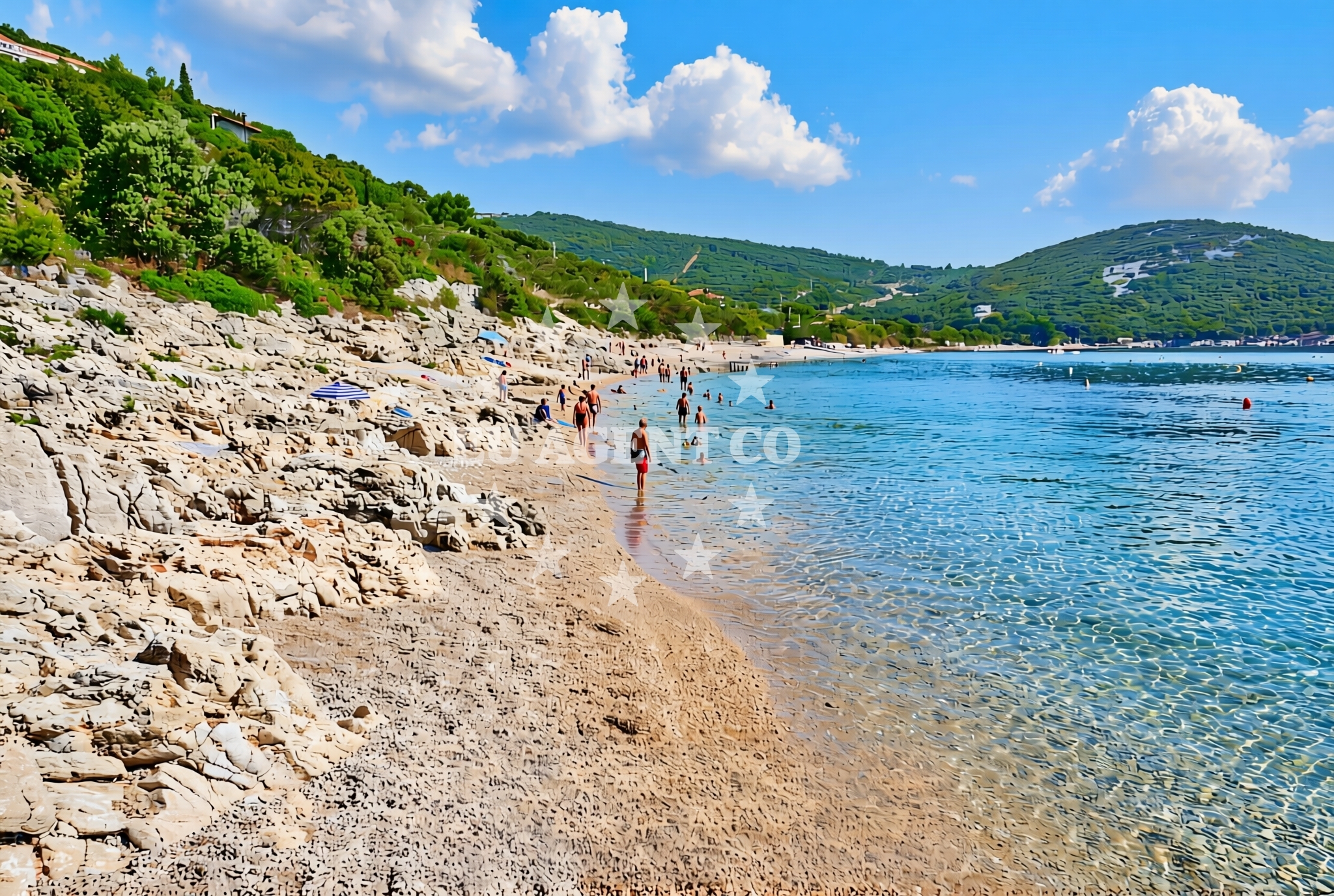
About this beach
Miholašćica sjever, Miholašćica (Cres)
Beach: Miholašćica sjever
Location: Miholašćica (Cres)
Characteristics and facilities
Gravel, rocks
Beach character
The beach's primary feature is its gravel and rocky composition, which extends along the shoreline in uneven formations. This terrain suggests a natural, unaltered coastline, likely shaped by long-term wave action and sediment deposition. The lack of sandy stretches means it is not suitable for sunbathing on traditional beach towels, but the rocky outcrops may provide opportunities for exploring tide pools or observing coastal flora and fauna. The beach's orientation on the northern coast of Cres exposes it to prevailing winds and waves, contributing to its dynamic, uneven profile.Swimming and shore
Swimming conditions at Miholašćica sjever depend on tidal patterns and wave activity. The rocky shoreline creates uneven entry points into the water, with deeper areas likely occurring between larger boulders. The beach's northern exposure means water temperatures may be cooler than in more sheltered parts of Cres. While the gravel and rocks make it unsuitable for children's play areas, the site could appeal to visitors seeking a more adventurous interaction with the coastline, such as wading through shallow, rocky pools.Facilities and activities
No formal facilities are documented for this beach, including showers, restrooms, or parking. The absence of structured amenities aligns with its natural, undeveloped character. Activities appear limited to passive recreation such as walking along the shore or observing the coastal landscape. The rocky terrain may restrict recreational use to those comfortable with uneven surfaces, though it could offer vantage points for photography or wildlife observation.Access and location
Miholašćica sjever is located on the northern coast of Cres, an island in the Kvarner Gulf. Access to the beach requires reaching Cres itself, which is served by ferry connections from Rijeka and other mainland ports. The beach's exact position on the island's northern shore places it near the boundary of the Cres and Lošinj archipelagos, areas known for their maritime history and natural beauty. The lack of road access suggests the site is reached via coastal paths or by sea, emphasizing its remote character.What to expect
Visitors should expect a rugged, gravelly shoreline with rocky formations that define the beach's character. The site lacks modern amenities, making it more suitable for those seeking a natural, unspoiled coastal environment. The northern exposure means conditions may be windier and cooler than in more sheltered parts of Cres. The beach's location on the island's northern coast positions it near historical and maritime routes, offering potential for contextual exploration beyond the immediate shoreline.Practical tips
Bring sturdy footwear for navigating the gravel and rocky terrain. The absence of facilities means visitors should carry water, snacks, and waste disposal supplies. Check tide times to assess swimming conditions, as the beach's rocky nature may create unpredictable entry points into the water. The site's remote character makes it less suitable for large groups or those requiring accessible amenities.Exploring the coast by yacht
The Kvarner Gulf, where Cres is located, is a well-established sailing region with several marinas and anchorages. Yacht charterers exploring this area may pass near Miholašćica sjever as part of a route along Cres's northern coast. The island's position between the mainland and the Istrian Peninsula makes it a strategic point for sailing itineraries, with connections to marinas in Rijeka, Krk, and the Istrian coast. While the beach itself is not a designated anchorage, its proximity to these maritime hubs could make it a reference point for sailors navigating the region.Historical Context of Cres
Cres has been inhabited since antiquity, with evidence of Roman settlements and medieval fortifications. The island's strategic location in the Kvarner Gulf made it a contested territory during various historical periods, leaving behind ruins and defensive structures. These historical layers add depth to visits to the island's coastline, including sites like Miholašćica sjever.Maritime Routes in the Kvarner Gulf
The Kvarner Gulf is a key sailing area with established routes connecting Rijeka, the Istrian coast, and islands like Krk and Lošinj. Yacht charterers often use Cres as a stopover, leveraging its proximity to both the mainland and other islands. The region's protected waters and scenic coastline make it a popular choice for both short and extended sailing trips.Anchorages in the surrounding area
Anchorages in the surrounding area include Martinscica, Stivan, and Ustrine on Cres.
- Anchorage — martinscica — cres — 0.2 NM from beach
- Anchorage — stivan — cres — 0.9 NM from beach
- Martinščica — ustrine — cres — 0.9 NM from beach
- Anchorage — martinscica — cres — 1.3 NM from beach
- Anchorage — martinscica — cres — 1.6 NM from beach
- Anchorage — cres — 1.7 NM from beach
- Anchorage — martinscica — cres — 2.6 NM from beach
- Anchorage — zeca — 3.1 NM from beach
Distances are straight-line geographic distances, not sailing routes.
Mooring buoys in the surrounding area
Mooring buoys in the surrounding area include jetty at Martinscica and buoy at Valun.
- Jetty — martinscica — cres — 1.0 NM from beach
- Jetty — martinscica — cres — 1.2 NM from beach
- Buoy — valun — cres — 6.0 NM from beach
- Jetty — cres — 6.0 NM from beach
- Osor — cres — 6.8 NM from beach
Distances are straight-line geographic distances, not sailing routes.
Marine fuel stations
Marine fuel stations are located in Nerezine on Losinj, Cres, and Krk.
- Tifon — nerezine — losinj — 8.1 NM from beach
- Ina — cres — 9.0 NM from beach
- Fuel station — cres — 9.4 NM from beach
- OMV — krk — 14.5 NM from beach
Distances are straight-line geographic distances, not sailing routes.
Harbours in the surrounding area
Harbours in the surrounding area include Martinšćica, Valun, and Nerezine on Cres and Losinj.
- Martinšćica — martinscica — cres — 1.0 NM from beach
- Valun harbour — cres — 6.0 NM from beach
- Nerezine — losinj — 8.8 NM from beach
- Cres Boatyard Marina — 9.3 NM from beach
- Cres harbour — 9.4 NM from beach
- Smokovac Bay — merag — cres — 11.1 NM from beach
Distances are straight-line geographic distances, not sailing routes.
Marinas in the surrounding area
Marinas in the surrounding area include ACI Marina Cres and Marina Nerezine on Losinj.
- ACI Marina Cres — 8.8 NM from beach
- Marina Nerezine — losinj — 9.0 NM from beach
- ACI Marina Supetarska Draga — rab — 15.3 NM from beach
- Marina Lošinj — mali losinj — 16.1 NM from beach
- Y/C Marina Mali Lošinj — mali losinj — 16.3 NM from beach
Distances are straight-line geographic distances, not sailing routes.
Restaurants near the beach
Restaurants near the beach include Korali, Sidro, and Kastel in Martinscica, as well as Pod Beli in Belej.
- Korali — martinscica — cres — 1.0 NM from beach
- Sidro — martinscica — cres — 1.0 NM from beach
- Kastel — martinscica — cres — 1.0 NM from beach
- Mare Mis — martinscica — cres — 1.4 NM from beach
- Zal — martinscica — cres — 1.5 NM from beach
- Pod Beli — belej — cres — 3.7 NM from beach
Distances are straight-line geographic distances, not sailing routes.
Navigation guides for the surrounding area
Navigation guides for the surrounding area include Martinscica, Ustrinska Luka, and Osor.
- Martinscica — 0.9 NM from beach
- Ustrinska Luka — 3.5 NM from beach
- Osor — 6.9 NM from beach
- Nerezine — 8.9 NM from beach
- Cres — 9.2 NM from beach
Distances are straight-line geographic distances, not sailing routes.
Yachts from nearby departure bases
Yachts from nearby departure bases in Mali Lošinj include various sail and motor boats.
Sailing yachts
- First 31.7 (Ruta) — Mali Lošinj — 16.2 NM from departure base to beach
- Bavaria 46 Cruiser (DEA) — Mali Lošinj — 16.2 NM from departure base to beach
- Sun Odyssey 32i (Cikat) — Mali Lošinj — 16.2 NM from departure base to beach
- Elan 50 Impression (Vuschi) — Mali Lošinj — 16.2 NM from departure base to beach
- Bavaria 37 Cruiser (Alani) — Mali Lošinj — 16.2 NM from departure base to beach
Motor boats
- Galeon Galia 700 — Mali Lošinj — 16.2 NM from departure base to beach
- Antares 36 (Joia) — Mali Lošinj — 16.2 NM from departure base to beach
- Invictus 200FX (1255ML) — Mali Lošinj — 16.2 NM from departure base to beach
- Atlantic Sun Cruiser 730 — Mali Lošinj — 16.2 NM from departure base to beach
- Galeon Galia 630 — Mali Lošinj — 16.2 NM from departure base to beach
Distances are straight-line geographic distances, not sailing routes.