Matejina uvala Beach, Croatia
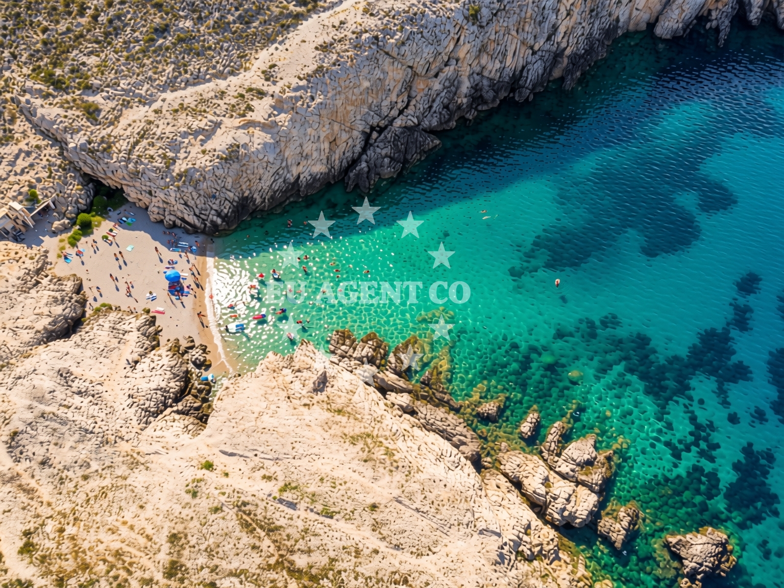
Matejina uvala is a small cove beach nestled in the rugged landscape of Vrsi, Croatia. Located at coordinates 44.28093, 15.22829, it is defined by its unique geological setting—a narrow bay framed by steep mountain slopes and a deep gorge. The beach consists of beige pebbles, with the sea floor similarly composed of pebbles that gradually slope downward. While the beach is marked as busy during peak seasons, its natural environment and moderate depth make it a distinctive spot along the Dalmatian coast.
Beach character
The beach’s most striking feature is its enclosed cove, measuring approximately 10 meters in width and depth. The surrounding landscape is dominated by mountainous terrain, with the gorge creating a dramatic backdrop. The pebbly shore and seabed contrast with the smooth, sheltered waters of the cove, which gradually deepen as one moves away from the shore. This geological configuration suggests a history of coastal erosion and sedimentation, typical of the region’s karst formations. The beach’s orientation and depth increase may influence local currents, though no specific navigational hazards are noted in the catalog.
Swimming and shore
The pebbly nature of Matejina uvala’s shore means swimming conditions are best suited for those comfortable with rocky terrain. The moderate depth increase allows for some swimming, though the beach is not ideal for young children or those seeking calm, shallow waters. The absence of structured amenities such as showers or changing facilities means visitors should plan accordingly. The beach’s natural setting, however, offers a tranquil environment for those seeking solitude or a connection to the landscape.
Facilities and activities
No formal amenities or structured activities are listed for Matejina uvala. The beach appears to be a natural, unspoiled spot without designated recreational infrastructure. Visitors are likely to find the area best suited for passive enjoyment, such as sunbathing, reading, or exploring the surrounding gorge. The lack of marked activities suggests the beach is not a hub for organized tourism, though its location may offer opportunities for hiking or photography in the nearby mountains.
Access and location
Matejina uvala is located in Vrsi, a small settlement on the Adriatic coast of Croatia. Its coordinates place it in a region known for its rugged coastline and hidden coves. The beach’s proximity to mountainous terrain may indicate limited road access, though no specific details about parking or pathways are provided in the catalog. The area is part of a broader network of coastal settlements along the Dalmatian coast, which is a popular destination for both land-based tourism and maritime exploration.
What to expect
Expect a small, secluded beach with a distinct natural character. The pebbly shore and surrounding gorge create a setting that is more rugged than the typical sandy beaches of the region. The beach is likely to be crowded during high season, as noted in the catalog, but its size and orientation may limit the number of visitors at any given time. Cleanliness is reported as good, though the absence of formal facilities means visitors should manage waste responsibly. The beach’s orientation and depth may make it a suitable spot for short swims or snorkeling, depending on local currents.
Practical tips
Bring sturdy footwear for the pebbly shore, and consider arriving early to avoid the busiest times during peak season. The beach’s natural setting means there are no on-site amenities, so bring essentials such as water, snacks, and sunscreen. Respect the environment by avoiding littering and minimizing disturbance to the local flora and fauna.
Exploring the coast by yacht
The region surrounding Matejina uvala is part of a broader sailing area along the Dalmatian coast, known for its clear waters and diverse anchorages. While the beach itself is not marked as an anchorage, nearby bays and inlets may offer opportunities for yacht charters through Euro-Agent. Sailors exploring the area could use Matejina uvala as a reference point, given its distinctive geological features. For those interested in chartering a yacht, the Euro-Agent Yacht Search page provides tools to find vessels operating in this region.
Regional Context and Nearby Exploration
The Dalmatian coast, where Matejina uvala is located, is characterized by its dramatic cliffs, hidden coves, and historic towns. The nearby settlement of Vrsi likely serves as a gateway to the area, with roads and trails connecting to other points of interest. The gorge surrounding the beach may be part of a larger network of natural landmarks, offering opportunities for hiking or geological study. For visitors interested in broader exploration, the region is within reach of other Adriatic destinations, including islands such as Hvar and Brac.
Anchorages in the surrounding area
Anchorages in the surrounding area include options near Vrsi and nearby locations such as Nin and Pag.
- Anchorage — vrsi — 0.7 NM from beach
- Anchorage — nin — 1.3 NM from beach
- Anchorage — nin — 1.7 NM from beach
- Anchorage — vlasici — pag — 2.2 NM from beach
- Anchorage — nin — 2.3 NM from beach
- Anchorage — smokvica — 2.7 NM from beach
- Anchorage — rtina — 2.9 NM from beach
- Anchorage — rtina — 3.0 NM from beach
Distances are straight-line geographic distances, not sailing routes.
Mooring buoys in the surrounding area
- Jetty — ljubac — 3.1 NM from beach
- Šibuljina Point — sibuljina point — 5.9 NM from beach
- Vir — 6.3 NM from beach
- Punta Skala — petrcane — 6.4 NM from beach
- Jetty — zadar — 9.2 NM from beach
Distances are straight-line geographic distances, not sailing routes.
Marine fuel stations
- Ina — zadar — 9.8 NM from beach
- Ina — preko — ugljan — 12.3 NM from beach
- Fuel station — sukosan — 14.0 NM from beach
- Ina — zaglav — dugi otok — 20.2 NM from beach
Distances are straight-line geographic distances, not sailing routes.
Harbours in the surrounding area
- Mulo — nin — 1.5 NM from beach
- Nin — 2.9 NM from beach
- Miškovići — miskovici — pag — 3.3 NM from beach
- Privlaka — 4.9 NM from beach
- Ražanac — razanac — 5.1 NM from beach
- Petrčane — petrcane — 6.4 NM from beach
Distances are straight-line geographic distances, not sailing routes.
Marinas in the surrounding area
- Marina Borik — zadar — 9.1 NM from beach
- Vitrenjak Zadar — 9.2 NM from beach
- Marina Zadar — 9.7 NM from beach
- Olive Island Marina — sutomiscica — ugljan — 11.4 NM from beach
- Marina Preko — ugljan — 12.1 NM from beach
Distances are straight-line geographic distances, not sailing routes.
Restaurants near the beach
Restaurants near the beach include options in Nin and Vir, providing dining choices in the vicinity.
- Tomislav — nin — 2.9 NM from beach
- Branimir — nin — 3.0 NM from beach
- Restaurant — vir — 4.7 NM from beach
Distances are straight-line geographic distances, not sailing routes.
Navigation guides for the surrounding area
Navigation guides for the surrounding area cover locations such as Privlaka and Otok Pag, aiding in route planning near the beach.
- Privlaka — 4.7 NM from beach
- OTOK PAG — 5.3 NM from beach
- KrusCica and Uvala KrusCica Duboka — 5.7 NM from beach
- VELESITSKI KANAL (S) — 6.0 NM from beach
- Starigrad-Paklenica {Velebitski Kanai) — 9.3 NM from beach
Distances are straight-line geographic distances, not sailing routes.
Yachts from nearby departure bases
Sailing yachts
- Sun Odyssey 410 (Vague) — Zadar Marina Borik — 9.1 NM from departure base to beach
- Bavaria 44 (Medena) — Zadar Marina Borik — 9.1 NM from departure base to beach
Catamarans
- Leopard 50 (Solaia) — Zadar Marina Borik — 9.1 NM from departure base to beach
- Sunreef 60 (SINATA) — Zadar Marina Borik — 9.1 NM from departure base to beach
Motor yachts
- Prestige 550 Fly (Floria) — Zadar Marina Borik — 9.1 NM from departure base to beach
Motor boats
- Merry Fisher 895 — Povljana Marina — 6.7 NM from departure base to beach
- Rancraft RM21 (Dugi otok) — Zadar Diklo Port — 7.8 NM from departure base to beach
- Rancraft RS Cinque.5 — Zadar Diklo Port — 7.8 NM from departure base to beach
- Rancraft RM19 (Daycruiser) — Zadar Diklo Port — 7.8 NM from departure base to beach
- Merry Fisher 795 (Jura 3212ZD) — Zadar Marina Borik — 9.1 NM from departure base to beach
Distances are straight-line geographic distances, not sailing routes.