Mali Raj Beach, Croatia
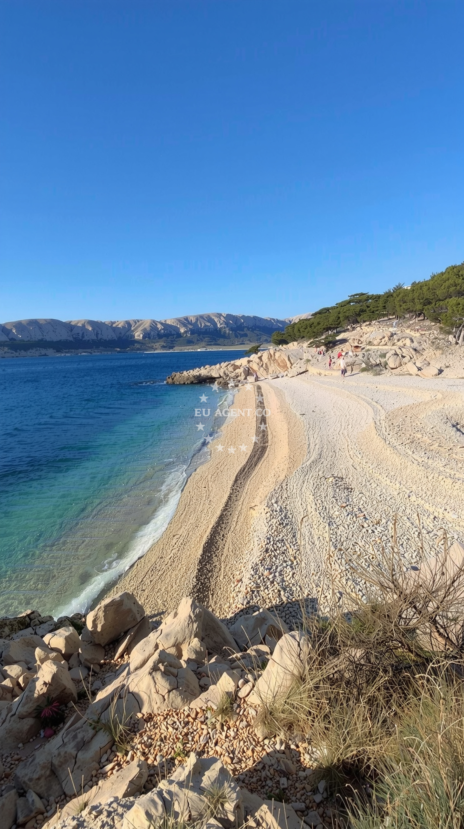
Beach character
The beach's defining feature is its pebble composition, with white stones forming the majority of the shoreline. Natural shade is provided by cliffs and a nearby pine forest, though sun protection is recommended during peak hours. The beach is classified as a cove, with a width of 40 meters and a moderate depth gradient. Its mountainous surroundings contribute to a sense of seclusion, though the area is accessible enough to maintain a moderate crowd level during high season.Swimming and shore
Swimming conditions are generally favorable, with clear waters that attract snorkelers and kayakers. The pebble substrate may require caution for barefoot swimmers, but the beach's depth increases gradually. Snorkeling opportunities are notable, with reviews mentioning visibility of marine life and vibrant underwater landscapes. The beach is designated as naturist-friendly, with visitor reports confirming a welcoming atmosphere for those preferring nude sunbathing.Facilities and activities
No formal amenities are present at the beach itself, though nearby parking options exist with varying fees. The primary activities associated with Mali Raj are kayaking and snorkeling, both facilitated by the beach's clear waters. The trail leading to the beach is a significant feature, with hikers noting the need for sturdy footwear due to rocky sections and exposed coastal paths.Access and location
The beach is accessible via a 30-40 minute hike from Baška, with multiple parking options available in the surrounding area. Reviews emphasize that the trail involves navigating rocky terrain and exposed coastal sections, making sports shoes essential. A notable correction to Google Maps directions suggests taking a right turn from Baška center to access the easier pathway. The beach is situated in the Primorje-Gorski Kotar region, part of Croatia's coastal landscape that extends along the Adriatic Sea.What visitors say
Visitors describe mixed experiences with the access route, with some finding the hike challenging but ultimately rewarding. Positive feedback highlights the beach's pristine waters, snorkeling opportunities, and the pine forest providing natural shade. One reviewer noted the beach's "crystal clear water" and "great view," while others emphasized the need for careful navigation on the trail. The naturist aspect is frequently mentioned as a defining characteristic, with reports of a "welcoming atmosphere" for those who prefer nude sunbathing.Practical tips
Bring sturdy footwear for the rocky trail to Mali Raj. Consider the Google Maps correction for accurate navigation from Baška. Sun protection is advisable despite natural shade from cliffs and pine trees. The beach's pebble surface may require caution when entering and exiting the water.Exploring the coast by yacht
Mali Raj's location on Croatia's northern Adriatic coast places it within a region popular with yacht charter guests. The surrounding area offers opportunities for coastal exploration, with nearby anchorages and marinas accessible via the Euro-Agent beaches map. Yacht charter operators in the region often highlight the combination of natural beauty and cultural heritage found along this stretch of coastline.Regional Context
Baška, the nearest settlement, is part of the Primorje-Gorski Kotar County, known for its mix of coastal and mountainous terrain. The area is characterized by traditional architecture and a strong connection to maritime traditions. Nearby towns offer cultural attractions, though the beach itself remains focused on natural experiences.Anchorages in the surrounding area
Anchorages near Vela Luka and Mala Luka are within 1.35 nautical miles of Mali raj in Baška.
- Anchorage — baska — krk — 1.3 NM from beach
- Vela Luka — krk — 1.3 NM from beach
- Mala Luka — krk — 1.7 NM from beach
- Anchorage — krk — 2.4 NM from beach
- Bracol — krk — 2.7 NM from beach
- Anchorage — prvic istria — 2.7 NM from beach
- Anchorage — krk — 3.7 NM from beach
- Anchorage — krk — 3.8 NM from beach
Distances are straight-line geographic distances, not sailing routes.
Mooring buoys in the surrounding area
- Jetty — krk — 1.3 NM from beach
- Jetty — krk — 1.4 NM from beach
- Buoy field — krk — 2.7 NM from beach
- Jetty — stara baska — krk — 4.0 NM from beach
- Jetty — stara baska — krk — 4.0 NM from beach
Distances are straight-line geographic distances, not sailing routes.
Marine fuel stations
Marine fuel stations in Krk and Novi Vinodolski are approximately 9.5 nautical miles from Mali raj in Baška.
- Flash — krk — 9.5 NM from beach
- INA — novi vinodolski — 9.6 NM from beach
- Ina — krk — 9.6 NM from beach
- Ina — rab — 12.5 NM from beach
Distances are straight-line geographic distances, not sailing routes.
Harbours in the surrounding area
The Baška harbor and Senj harbor are within 5.2 nautical miles of Mali raj in Baška.
- Baška — baska — krk — 0.9 NM from beach
- Senj — 5.2 NM from beach
- St. Juraj — st juraj — 6.2 NM from beach
- Melna — goli otok — 7.3 NM from beach
- Punat — krk — 7.3 NM from beach
- Lukovo — 8.0 NM from beach
Distances are straight-line geographic distances, not sailing routes.
Marinas in the surrounding area
Marinas in Punat and Novi Vinodolski are approximately 7.6 nautical miles from Mali raj in Baška.
- Marina Punat — krk — 7.6 NM from beach
- Mitan Marina — novi vinodolski — 9.4 NM from beach
- Marina Novi — novi vinodolski — 9.7 NM from beach
- ACI Marina Supetarska Draga — rab — 10.1 NM from beach
- Šilo — silo — krk — 12.1 NM from beach
Distances are straight-line geographic distances, not sailing routes.
Restaurants near the beach
Restaurants in Baška and Vela Luka are within 1.35 nautical miles of Mali raj in Baška.
- Restaurant — baska — krk — 0.9 NM from beach
- Restaurant — baska — krk — 1.0 NM from beach
- Vela Luka — krk — 1.3 NM from beach
- Mala Luka — krk — 1.8 NM from beach
- Restaurant — krk — 2.6 NM from beach
- Restaurant — stara baska — krk — 4.0 NM from beach
- Mariana Restaurant — stara baska — krk — 4.0 NM from beach
Distances are straight-line geographic distances, not sailing routes.
Navigation guides for the surrounding area
Navigation guides for Baška and Uvala Vela Luka are within 1.5 nautical miles of Mali raj in Baška.
- Baška — 0.7 NM from beach
- Uvala Vela Luka — 1.5 NM from beach
- Senj — 5.4 NM from beach
- Uvala Sv. Jelena — 5.6 NM from beach
- Jurjevo (Luka Sv. Juraj) — 6.4 NM from beach
Distances are straight-line geographic distances, not sailing routes.
Yachts from nearby departure bases
Yachts departing from Krk Punat port and Marina Punat are approximately 7.37 nautical miles from Mali raj in Baška.
Sailing yachts
- First 25.7 (Petra) — Krk Punat port — 7.4 NM from departure base to beach
- Salona 45 (Nati) — Krk Punat port — 7.4 NM from departure base to beach
- Bavaria Cruiser 46 (GARBIN) — Krk Marina Punat — 7.6 NM from departure base to beach
- Bavaria 40 Cruiser (Star Philip) — Krk Marina Punat — 7.6 NM from departure base to beach
Catamarans
- Lagoon 380 (Xenia) — Krk Punat port — 7.4 NM from departure base to beach
- Lucia 40 (STELLA LUNA) — Krk Marina Punat — 7.6 NM from departure base to beach
- Lagoon 40 (Sunset) — Krk Marina Punat — 7.6 NM from departure base to beach
Motor yachts
- Sunseeker 64 (MARITA) — Krk Marina Punat — 7.6 NM from departure base to beach
- Galeon 500 Fly (Barbara) — Krk Marina Punat — 7.6 NM from departure base to beach
Motor boats
- Monte Carlo 37 Hard Top (Tindra) — Krk Marina Punat — 7.6 NM from departure base to beach
Distances are straight-line geographic distances, not sailing routes.
Frequently asked questions
Is there parking available near Mali Raj Beach?
Multiple parking options exist in the surrounding area, though fees vary. Visitors should be prepared for a short walk from parking areas to the beach.What is the best way to reach Mali Raj Beach?
A 30-40 minute hike from Baška is the primary access route. A correction to Google Maps directions suggests taking a right turn from Baška center for an easier pathway.Nearby beaches
Reviews
it is a wild, nice beach, you need some 30 minutes walk from Baška. No shade here.
Very beautiful beach!! ;) Water is very clear and nice, with a great view and a lot of fishes. It was a bit windy in the morning, but not in the afternoon. You can reach it by taxi boat, but we decided to take the trail from Baska. It took us about 40 minutes from our parking (there are several with different fares). Please consider that the trail is partly very exposed on the coastline, with rocks and some potentially difficult spots, especially if the wind blows. We recommend using sports shoes and comfortable clothing. Also bring your own umbrella because the shadow spots are only in the forest. You can walk on to the following beaches, like Dubna, buy again consider the "intersections" of the trail, very exposed. Enjoy!
Beautiful beach, but at 28 degrees it was not worth the terribly difficult walk there. We are young, but we had a hard time jumping on the rocks, crawling and climbing. Sneakers are compulsory, some parts are dangerous, you have to be prepared for that. There were hardly any people on the beach, so it was a wonderful experience to finally get there and swim in the sunset.
We didn’t check the route properly, so we went there in slippers - it was a mistake. Really hard. But we got there and back without any harm, it is really worth it. There is a mistake on Google maps, if you go from Baška center definitely keep right, continue straight along the sea. On Google maps it looks like there is no pathway, but there is and it is much much much easier and quicker.
Such a beautiful beach, crystal clear water, good for snorkeling as well. You can sunbathe nude or in swimwear, everyone is accepting. There is a pine wood that offers a lot of shade. Worth visiting! Primorje-Gorski Kotar