Mala lučica, Splitska (Brač) Beach, Croatia
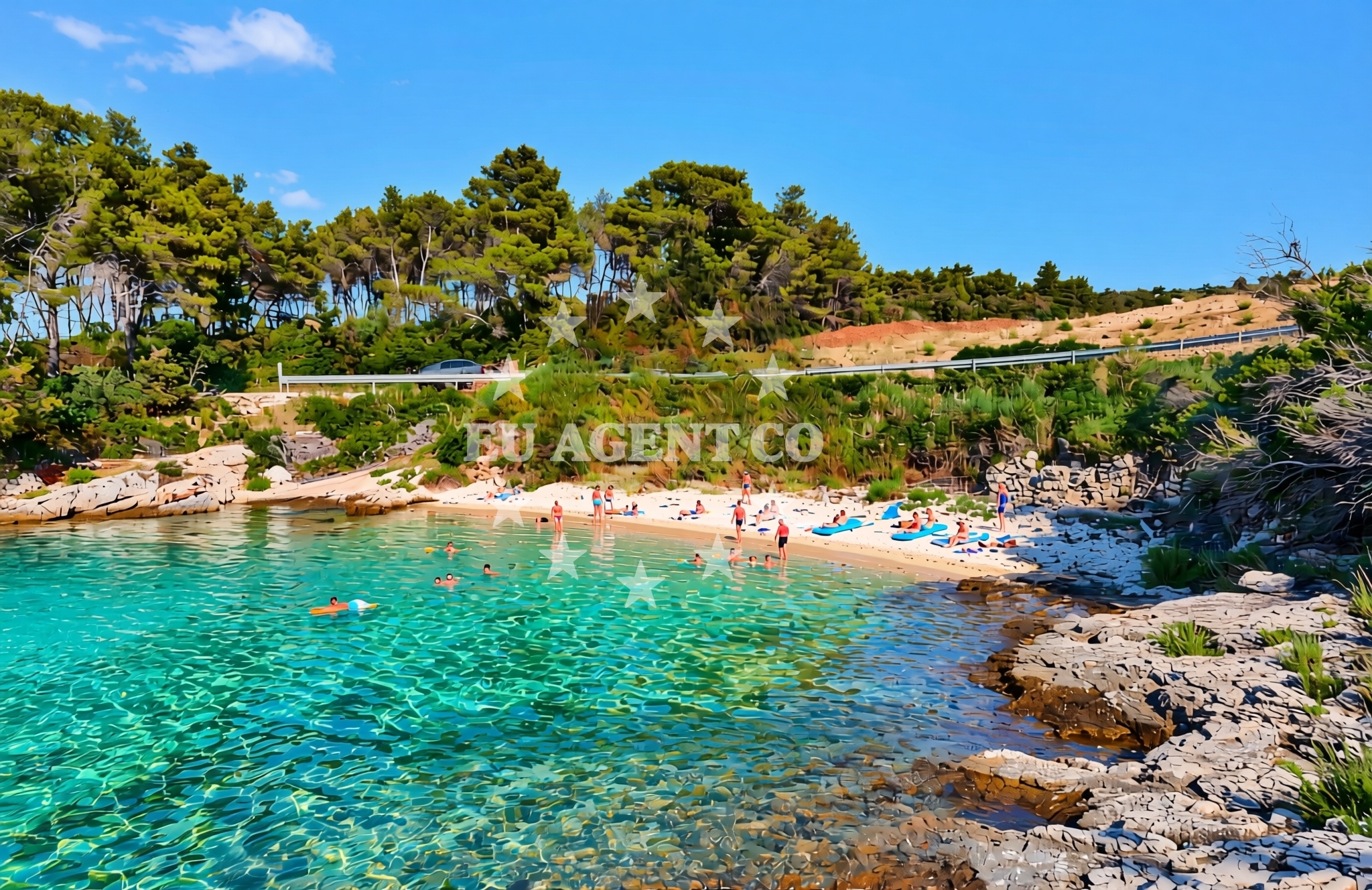
About this beach
Mala lučica, Splitska (Brač)
Beach: Mala lučica
Location: Splitska (Brač)
Beach character
Mala lučica is a small, unmarked beach that lies within a landscape shaped by Brač’s geological history. The island’s famous white limestone, which gives the region its distinctive appearance, is visible in the cliffs and rock formations near the shore. The beach itself appears to be a natural extension of this terrain, with pebbles and rocky outcrops forming its shoreline. While the exact dimensions of the beach are not documented, its location suggests it may be a short, intimate stretch of coast, ideal for those seeking solitude away from more developed areas of Brač.Swimming and shore
The Adriatic Sea is renowned for its warm, clear waters, and Mala lučica is no exception. Swimmers can expect conditions typical of the region: calm, shallow waters near the shore that gradually deepen toward the open sea. The rocky nature of the beach may make it less suitable for young children, but it offers a unique opportunity to explore tidal pools and marine life in the shallows. The shoreline’s composition of pebbles and stone means visitors should bring a towel or mat for comfort, though no formal facilities like showers or changing rooms are listed for the beach itself.Facilities and activities
No specific facilities are documented for Mala lučica, but its location near Splitska and Brač’s broader infrastructure means visitors can access nearby services. The village of Splitska, a short drive inland, offers traditional Dalmatian taverns, artisanal shops, and a glimpse into rural island life. For those interested in outdoor activities, Brač’s network of hiking trails, including routes to the island’s highest peak, Vidova Gora, provides opportunities for exploration. Snorkeling and kayaking are popular in the surrounding waters, though these activities are not explicitly tied to the beach itself.Access and location
Mala lučica is located in the village of Splitska on Brač Island, approximately 25 kilometers from the town of Split on the mainland. The island is accessible via ferry services from Split’s port, with regular crossings to Supetar, Brač’s main town, and other points along the coast. From Splitska, the beach is reachable by car or on foot, with the nearest road connecting to the island’s main routes. Coordinates for the beach are 43.380366° N, 16.590912° E, and a map view is available through Euro-Agent’s beaches map for precise navigation.What to expect
Visitors to Mala lučica should expect a natural, low-key beach experience that reflects Brač’s rugged coastline. The area is likely to be less crowded than more tourist-centric beaches on the island, making it an appealing spot for those seeking tranquility. While no formal amenities are listed, the beach’s proximity to Splitska means visitors can access local dining, accommodations, and cultural sites. The surrounding landscape offers opportunities for photography, hiking, and exploring Brač’s unique geology, though the beach itself appears to be a quiet, unmarked stretch of shoreline.Practical tips
As with many natural beaches in the region, visitors are advised to bring their own towels, water, and sunscreen, as no formal facilities are listed for Mala lučica. The rocky shoreline may make it less ideal for young children, but it’s a great spot for those interested in exploring tidal pools or enjoying the sea from a vantage point. For dining and overnight stays, Splitska and nearby Supetar offer a range of options, from traditional seafood restaurants to boutique accommodations.Exploring the coast by yacht
Brač is a popular destination for yacht charter guests, with its sheltered bays, clear waters, and proximity to other Dalmatian islands like Hvar and Vis. Mala lučica’s location on the island’s southern coast places it within a sailing area that includes the famous Blue Cave and the island’s many anchorages. Charter guests exploring the region may find the beach a convenient stop for a quiet swim or picnic, though it is not marked as a formal marina or anchorage. For those interested in yacht charter opportunities, Euro-Agent’s yacht search page provides access to boats available for hire in the area.Cultural and Historical Context of Brač
Brač Island has a rich history dating back to ancient times, with evidence of Illyrian, Roman, and Byzantine influences. The island is also known for its production of white wine, with vineyards visible in the hills surrounding Splitska. Visitors interested in history may explore the remains of the ancient town of Imbros, a UNESCO World Heritage site, or visit the Church of St. Nicholas in Splitska, a 15th-century structure that reflects the island’s medieval past.Anchorages in the surrounding area
Anchorages in the surrounding area include Splitska, Postira, and Supetar, which are near Mala lučica, Splitska (Brač) Beach.
- Anchorage — splitska — brac — 0.4 NM from beach
- Anchorage — postira — brac — 1.4 NM from beach
- Anchorage — supetar — brac — 2.4 NM from beach
- Anchorage — postira — brac — 3.3 NM from beach
- Konopjikova — postira — brac — 4.0 NM from beach
- Uvala Likva — sutivan — brac — 5.7 NM from beach
- Bobovišća — bobovisce — brac — 6.0 NM from beach
- Stiniva — brac — 6.2 NM from beach
Distances are straight-line geographic distances, not sailing routes.
Mooring buoys in the surrounding area
Mooring buoys in the surrounding area are located in Postira, Podstrana, and Bobovisce, close to Mala lučica, Splitska (Brač) Beach.
- Quay — postira — brac — 4.1 NM from beach
- Jetty — podstrana — 5.7 NM from beach
- Nautical Anchorage Bobovišća — bobovisce — brac — 5.9 NM from beach
- Nautical Anchorage Bobovišća — bobovisce — brac — 6.0 NM from beach
- Buoy — milna brac — 7.5 NM from beach
Distances are straight-line geographic distances, not sailing routes.
Marine fuel stations
- Ina — milna brac — 7.2 NM from beach
- Fuel station — bol — brac — 7.7 NM from beach
- Ina — split — 10.2 NM from beach
- Ina — split — 10.7 NM from beach
Distances are straight-line geographic distances, not sailing routes.
Harbours in the surrounding area
Harbours in the surrounding area include Splitska, Postira, and Dugi Rat, near Mala lučica, Splitska (Brač) Beach.
- Splitska — brac — 0.7 NM from beach
- Postira — brac — 1.6 NM from beach
- Supetar — brac — 1.6 NM from beach
- Pod Mirca — brac — 3.0 NM from beach
- Dugi Rat — 4.3 NM from beach
- Sumpetar — dugi rat — 4.5 NM from beach
Distances are straight-line geographic distances, not sailing routes.
Marinas in the surrounding area
Marinas in Milna, Podstrana, and Split are situated in proximity to Mala lučica, Splitska (Brač) Beach.
- ACI Marina Milna — milna brac — 7.0 NM from beach
- Marina Lav — podstrana — 7.1 NM from beach
- Marina Milna Kanarija — milna brac — 7.2 NM from beach
- Marina Vlaška — milna brac — 7.3 NM from beach
- ACI Marina Split — 10.1 NM from beach
Distances are straight-line geographic distances, not sailing routes.
Restaurants near the beach
Restaurants in Splitska, Supetar, and Postira are located near Mala lučica, Splitska (Brač) Beach.
- Vala — splitska — brac — 0.7 NM from beach
- Mala Kate — supetar — brac — 1.5 NM from beach
- Vinotoka — supetar — brac — 1.6 NM from beach
- Lukin — supetar — brac — 1.7 NM from beach
- Galija — postira — brac — 1.7 NM from beach
- Neven — supetar — brac — 1.9 NM from beach
- Konoba Kopačina — donji humac — brac — 2.7 NM from beach
Distances are straight-line geographic distances, not sailing routes.
Navigation guides for the surrounding area
Navigation guides for Uvala Spliska, Postire, and Dugi Rat are relevant to Mala lučica, Splitska (Brač) Beach.
- Uvala Spliska (Splitska) — 0.8 NM from beach
- Postire — 1.8 NM from beach
- Dugi Rat (Uvala Orisac) — 4.3 NM from beach
- Sutivan — 4.7 NM from beach
- Omis — 6.0 NM from beach
Distances are straight-line geographic distances, not sailing routes.
Yachts from nearby departure bases
Sailing yachts
- Jeanneau 53 (Win Win) — Podstrana Marina Lav — 7.1 NM from departure base to beach
Catamarans
- Lagoon 450 Fly (Falco) — Sumpetar Port — 4.5 NM from departure base to beach
Motor yachts
- Aicon 56 (Senza Parole) — Podstrana Marina Lav — 7.1 NM from departure base to beach
Gulets / Cruisers
- Gulet (Cataleya) — Sumpetar Port — 4.5 NM from departure base to beach
- Gulet (Altair) — Sumpetar Port — 4.5 NM from departure base to beach
- Gulet cruiser (AGORA) — Dugi Rat Luka Krilo — 4.8 NM from departure base to beach
- Gulet (Trebenna) — Omiš City Port — 5.8 NM from departure base to beach
- Gulet (Primorac) — Omiš City Port — 5.8 NM from departure base to beach
- Gulet (PATRONICE) — Omiš City Port — 5.9 NM from departure base to beach
Motor boats
- Cranchi M44 HT (Brown Sugar) — Podstrana Marina Lav — 7.1 NM from departure base to beach
Distances are straight-line geographic distances, not sailing routes.