Katoro Beach, Croatia
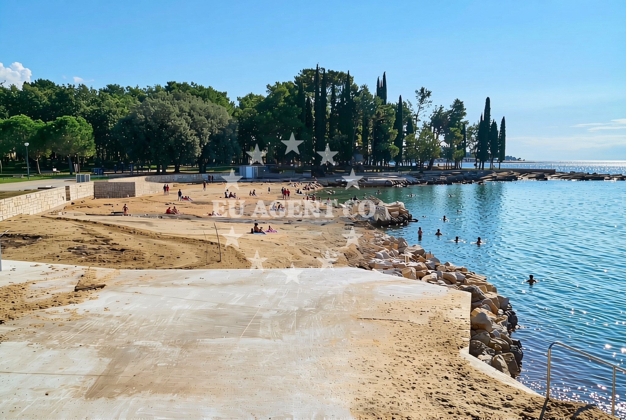
Katoro Beach, located in the coastal town of Katoro, offers a unique shoreline composition of sand, gravel, and concrete/stone slabs. Situated along Croatia's eastern Adriatic coast, this beach provides a mix of natural and developed features, making it a point of interest for both local visitors and those exploring the region by sea.
About this beach
Katoro jug, Katoro
Beach: Katoro jug
Location: Katoro
Characteristics and facilities
Sand, gravel, concrete / stone slabs
300 m
Restaurant / snack bar
Caffe bar / Drinks stand
Changing cabin
Beach character
The beach stretches approximately 300 meters along the coastline, with a varied surface that includes sandy sections, gravel, and concrete/stone slabs. This combination may appeal to visitors seeking a more rugged shoreline experience. The beach is equipped with a changing cabin, providing basic facilities for swimmers and sunbathers.
Swimming and shore
Swimming conditions at Katoro Beach are influenced by the surrounding geography and seasonal weather patterns. The shoreline's mix of sand and concrete slabs may create varied water entry points. While no specific water depth or current data is available, the beach's proximity to the Adriatic Sea suggests typical coastal swimming conditions for the region.
Facilities and activities
Basic amenities include a restaurant, snack bar, and caffe bar, offering refreshments to visitors. The presence of a changing cabin indicates some level of infrastructure for beachgoers. No structured activities or rental services are explicitly listed in the beach's catalog.
Access and location
Katoro Beach is located in the town of Katoro, which lies along the coast of Croatia's eastern Adriatic region. The area is part of a broader network of coastal settlements that connect to maritime routes and sailing areas. Nearby towns and islands may provide additional context for visitors exploring the region by land or sea.
What to expect
Visitors to Katoro Beach can expect a shoreline with a mix of sand, gravel, and concrete/stone slabs, spanning approximately 300 meters. The beach includes a changing cabin and is served by a nearby restaurant, snack bar, and caffe bar. As with many coastal destinations in the Adriatic, the beach's character is shaped by its natural setting and local infrastructure.
Practical tips
Given the beach's varied shoreline composition, visitors may want to consider bringing appropriate footwear for walking on concrete slabs. The availability of changing facilities suggests that basic beachgoer needs are met, though no additional services are explicitly listed.
Exploring the coast by yacht
The eastern Adriatic coast, where Katoro Beach is located, is a well-known sailing region with a network of marinas, anchorages, and coastal routes. Yacht charter guests exploring this area may find Katoro Beach as a potential stop along their journey, though the beach itself is not explicitly marked as an anchorage or marina. The surrounding waters offer opportunities for coastal cruising, with connections to other Adriatic destinations.
Regional Context and Coastal Connections
The area around Katoro Beach is part of Croatia's eastern Adriatic coastline, which is characterized by a mix of natural beaches, rocky shores, and developed coastal settlements. This region is a popular destination for yacht charter guests, with sailing routes that extend to nearby islands and coastal towns. The Adriatic Sea's mild climate and clear waters make it an attractive destination for both leisure and charter sailing.
Anchorages in the surrounding area
Anchorages in the surrounding area include options in Kanegra, Krizine, and Lovrecica, located within a few nautical miles.
- Anchorage — kanegra — 2.7 NM from beach
- Anchorage — krizine — 3.5 NM from beach
- Anchorage — lovrecica — 4.1 NM from beach
- Anchorage — lovrecica — 4.9 NM from beach
- Anchorage — dalja — 6.2 NM from beach
- Anchorage — novigrad istarski — 9.4 NM from beach
- Anchorage — novigrad istarski — 9.7 NM from beach
- Anchorage — cervar porat — 11.3 NM from beach
Distances are straight-line geographic distances, not sailing routes.
Mooring buoys in the surrounding area
Mooring buoys in the surrounding area feature fields in Umag and Savudrija, along with jetties in Kanegra and Lovrecica.
- Buoy field — umag — 1.3 NM from beach
- Buoy field — savudrija — 2.6 NM from beach
- Jetty — kanegra — 2.7 NM from beach
- Jetty — lovrecica — 4.7 NM from beach
- Jetty — dalja — 6.1 NM from beach
Distances are straight-line geographic distances, not sailing routes.
Marine fuel stations
- Ina — umag — 1.1 NM from beach
- Fuel station — drace — 7.6 NM from beach
- Fuel station — split — 7.6 NM from beach
- Crodux — novigrad istarski — 8.6 NM from beach
Distances are straight-line geographic distances, not sailing routes.
Harbours in the surrounding area
- Stella Maris — umag — 0.3 NM from beach
- Umag — 1.4 NM from beach
- Stara Savudrija — 2.6 NM from beach
- Novigrad — novigrad istarski — 8.5 NM from beach
- Mirna — novigrad istarski — 9.5 NM from beach
- Harbour Poreč — harbour porec — 14.2 NM from beach
Distances are straight-line geographic distances, not sailing routes.
Marinas in the surrounding area
- ACI marina Umag — 1.1 NM from beach
- Marina Nautica — novigrad istarski — 8.6 NM from beach
- Marina Červar Porat — marina cervar porat — 11.5 NM from beach
- Marina Poreč — marina porec — 14.4 NM from beach
- Marina Parentium — porec — 15.6 NM from beach
Distances are straight-line geographic distances, not sailing routes.
Restaurants near the beach
Restaurants near the beach include Lido and Punta in Umag, offering dining options within a short distance.
- Lido — umag — 1.1 NM from beach
- Restaurant Punta — umag — 1.1 NM from beach
- Amfora — umag — 1.5 NM from beach
- Konoba Nono — umag — 2.5 NM from beach
Distances are straight-line geographic distances, not sailing routes.
Navigation guides for the surrounding area
Navigation guides for the surrounding area cover locations such as Umag, Pi Ran, and Izola, aiding in route planning.
- Umag — 1.2 NM from beach
- Pi ran — 4.6 NM from beach
- Izola — 7.8 NM from beach
- Novi grad — 8.5 NM from beach
- Luka Crvar and Marina Crvar-Porat — 11.2 NM from beach
Distances are straight-line geographic distances, not sailing routes.
Yachts from nearby departure bases
Sailing yachts
- Bavaria 40 (Conny) — Poreč Marina Funtana — 17.2 NM from departure base to beach
- Gib Sea 43 (Leonardo) — Poreč Marina Funtana — 17.2 NM from departure base to beach
- Bavaria 32 (Vroni) — Poreč Marina Funtana — 17.2 NM from departure base to beach
- Bavaria 44 (Franzi) — Poreč Marina Funtana — 17.2 NM from departure base to beach
- Bavaria 49 (Tortola) — Poreč Marina Funtana — 17.2 NM from departure base to beach
Catamarans
- Lagoon Power 44 (Monteki) — Poreč Marina Funtana — 17.2 NM from departure base to beach
Motor boats
- Prestige 46 Fly (Anima Maris) — Marina Novigrad — 8.5 NM from departure base to beach
- Maiora 20 (Sea Heaven) — Marina Novigrad — 8.5 NM from departure base to beach
- AC DC Daycruiser 12.0 — Marina Novigrad — 8.5 NM from departure base to beach
- Maiora 20 (Sea Heaven) — Marina Novigrad — 8.5 NM from departure base to beach
Distances are straight-line geographic distances, not sailing routes.