Jazškalice, Seline Beach, Croatia
About this beach
Jazškalice, Seline
Beach: Jazškalice
Location: Seline
Characteristics and facilities
Gravel, concrete / stone slabs
160 m
Natural shade
Beach character
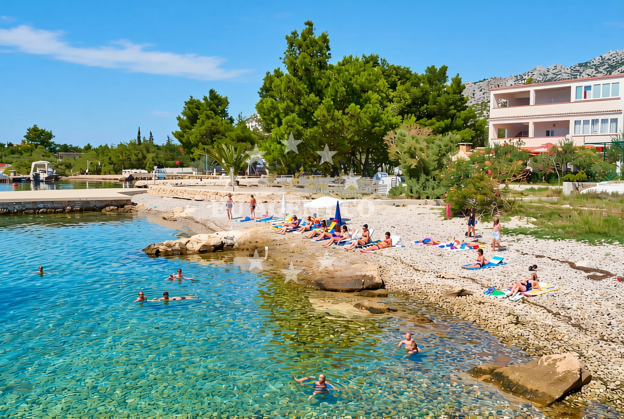
The beach's surface consists of gravel and stone slabs, a characteristic that may appeal to those seeking a more rugged or unconventional shoreline experience. Its 160-meter length provides a modest but defined space for visitors. Natural shade, possibly from overhanging rock formations or vegetation, offers intermittent relief from direct sunlight. This feature may be particularly useful during peak summer months when sun exposure is more intense.Swimming and shore
While specific swimming conditions are not documented, the gravel and stone composition of the beach may influence water access. The shoreline's texture could create a distinct contrast with the sea, potentially affecting wave dynamics near the shore. Visitors should consider the surface type when planning activities, as it may differ from sandy beaches in terms of comfort and usability.Facilities and activities
No formal facilities or structured activities are explicitly listed for this beach. The absence of detailed amenities suggests a more natural, undeveloped character. Visitors should assume minimal infrastructure, focusing instead on the beach's inherent features and the surrounding coastal environment.Access and location
Jazškalice, Seline Beach is situated in the village of Jazškalice, a coastal settlement in Croatia's Adriatic region. The area is part of a larger coastline that extends toward the islands of Brač and Hvar, both of which are popular destinations for maritime tourism. The beach's proximity to these islands may make it a convenient starting point for exploring the region's coastal routes, though specific access details such as road connections or parking are not provided in the catalog.What to expect
Visitors should expect a beach defined by its gravel and stone slabs, with natural shade providing intermittent relief. The shoreline's character is likely to be more rugged than typical sandy beaches, making it suitable for those seeking a distinct coastal experience. The beach's location in Jazškalice connects it to the broader Adriatic landscape, where maritime traditions and natural beauty are prominent features.Practical tips
Given the beach's surface composition, visitors may want to wear appropriate footwear for comfort. The natural shade can be a useful feature during sunny periods, though it is not continuous. Those planning extended stays may want to consider the surrounding area's maritime offerings, as the region is known for its sailing opportunities.Exploring the coast by yacht
The Adriatic coast near Jazškalice is a well-established sailing region, with routes connecting to nearby islands and coastal towns. Euro-Agent offers yacht charter services that can facilitate exploration of this area, allowing visitors to experience the region's maritime charm from the water. While specific marinas or anchorage points are not detailed here, the broader sailing context highlights the area's appeal to charter guests interested in coastal navigation.Regional Context and Coastal Character
The area around Jazškalice is part of Croatia's Dalmatian coast, a region defined by its dramatic cliffs, clear waters, and historic settlements. The coastline here is characterized by a mix of rocky inlets and sheltered coves, which contribute to the area's appeal for both leisure and maritime activities. Local traditions often reflect the region's deep connection to the sea, with fishing and sailing remaining significant cultural elements.Anchorages in the surrounding area
Anchorages in the surrounding area include Vinjerac, Maslenica, and Rtina.
- Anchorage — vinjerac — 1.5 NM from beach
- Anchorage — maslenica — 6.3 NM from beach
- Anchorage — rtina — 7.4 NM from beach
- Anchorage — rtina — 7.4 NM from beach
- Anchorage — ljubac — 7.6 NM from beach
- Anchorage — ljubac — 7.6 NM from beach
- Anchorage — novigrad — 8.3 NM from beach
- Anchorage — tribanj — 9.1 NM from beach
Distances are straight-line geographic distances, not sailing routes.
Mooring buoys in the surrounding area
Mooring buoys in the surrounding area include Šibuljina Point and Jetty in Ljubac.
- Šibuljina Point — sibuljina point — 6.4 NM from beach
- Jetty — ljubac — 7.7 NM from beach
- Jetty — zadar — 14.2 NM from beach
- Jetty — zadar — 14.2 NM from beach
- Punta Skala — petrcane — 14.9 NM from beach
Distances are straight-line geographic distances, not sailing routes.
Marine fuel stations
- Ina — zadar — 14.3 NM from beach
- Fuel station — sukosan — 15.6 NM from beach
- Ina — preko — ugljan — 17.1 NM from beach
- Ina — biograd na moru — 20.7 NM from beach
Distances are straight-line geographic distances, not sailing routes.
Harbours in the surrounding area
Harbours in the surrounding area include Seline, Starigrad Paklenica, and Vinjerac.
- Seline — 0.4 NM from beach
- Starigrad Paklenica — 1.5 NM from beach
- Vinjerac — 1.5 NM from beach
- Maslenica — 4.8 NM from beach
- Ražanac — razanac — 5.2 NM from beach
- Obrovac — 10.4 NM from beach
Distances are straight-line geographic distances, not sailing routes.
Marinas in the surrounding area
Marinas in the surrounding area include Marina Zadar, Vitrenjak Zadar, and Marina Dalmacija in Sukosan.
- Marina Zadar — 14.3 NM from beach
- Vitrenjak Zadar — 14.3 NM from beach
- Marina Borik — zadar — 14.4 NM from beach
- Marina Dalmacija — sukosan — 15.5 NM from beach
- Olive Island Marina — sutomiscica — ugljan — 17.0 NM from beach
Distances are straight-line geographic distances, not sailing routes.
Restaurants near the beach
Restaurants near the beach include Gostionica Ivan in Seline and Buffet Paklenica in Starigrad Paklenica.
- Restaurant — seline — 0.5 NM from beach
- Gostionica Ivan — seline — 0.7 NM from beach
- Buffet Paklenica — starigrad paklenica — 0.8 NM from beach
- Restaurant — starigrad paklenica — 0.9 NM from beach
Distances are straight-line geographic distances, not sailing routes.
Navigation guides for the surrounding area
Navigation guides for the surrounding area cover Starigrad-Paklenica and Posedarje.
- Starigrad-Paklenica {Velebitski Kanai) — 1.3 NM from beach
- Posedarje (Novigradsko More) — 4.5 NM from beach
- VELESITSKI KANAL (S) — 5.1 NM from beach
- KrusCica and Uvala KrusCica Duboka — 7.5 NM from beach
- Privlaka — 15.0 NM from beach
Distances are straight-line geographic distances, not sailing routes.
Yachts from nearby departure bases
Yachts from nearby departure bases include those departing from Novigrad Dalmatia and Zadar Marina.
Sailing yachts
- Bavaria Cruiser 46 (Jameson) — Zadar Marina — 14.3 NM from departure base to beach
- Bavaria C46 (Tulipa) — Zadar Marina — 14.3 NM from departure base to beach
Catamarans
- Delta F40-XT (Veronchie) — Zadar Marina — 14.3 NM from departure base to beach
- Bali 4.6 (Jako 2) — Zadar Marina — 14.3 NM from departure base to beach
Motor boats
- Merry Fisher 795 () — Novigrad Dalmatia — 6.9 NM from departure base to beach
- Rancraft RM21 (Dugi otok) — Zadar Diklo Port — 13.9 NM from departure base to beach
- Rancraft RS Cinque.5 — Zadar Diklo Port — 13.9 NM from departure base to beach
- Rancraft RM19 (Daycruiser) — Zadar Diklo Port — 13.9 NM from departure base to beach
- Shark BF 23 Sport (Hrvoje) — Zadar Marina — 14.3 NM from departure base to beach
- Tempest 650 (CAPELLI) — Zadar Marina — 14.3 NM from departure base to beach
Distances are straight-line geographic distances, not sailing routes.