Ćuskijaš sjever, Pridraga Beach, Croatia
Ćuskijaš sjever, Pridraga Beach lies along the Adriatic coast in Croatia, offering a unique gravel shoreline that contrasts with more conventional sandy beaches. Located in the settlement of Pridraga, the beach stretches approximately 80 meters and is characterized by its natural composition and minimal artificial development. The site includes a restaurant, snack bar, and caffe bar, providing visitors with on-site refreshments. Natural shade from surrounding vegetation offers respite from the sun, making it a practical choice for those seeking comfort during warmer months.
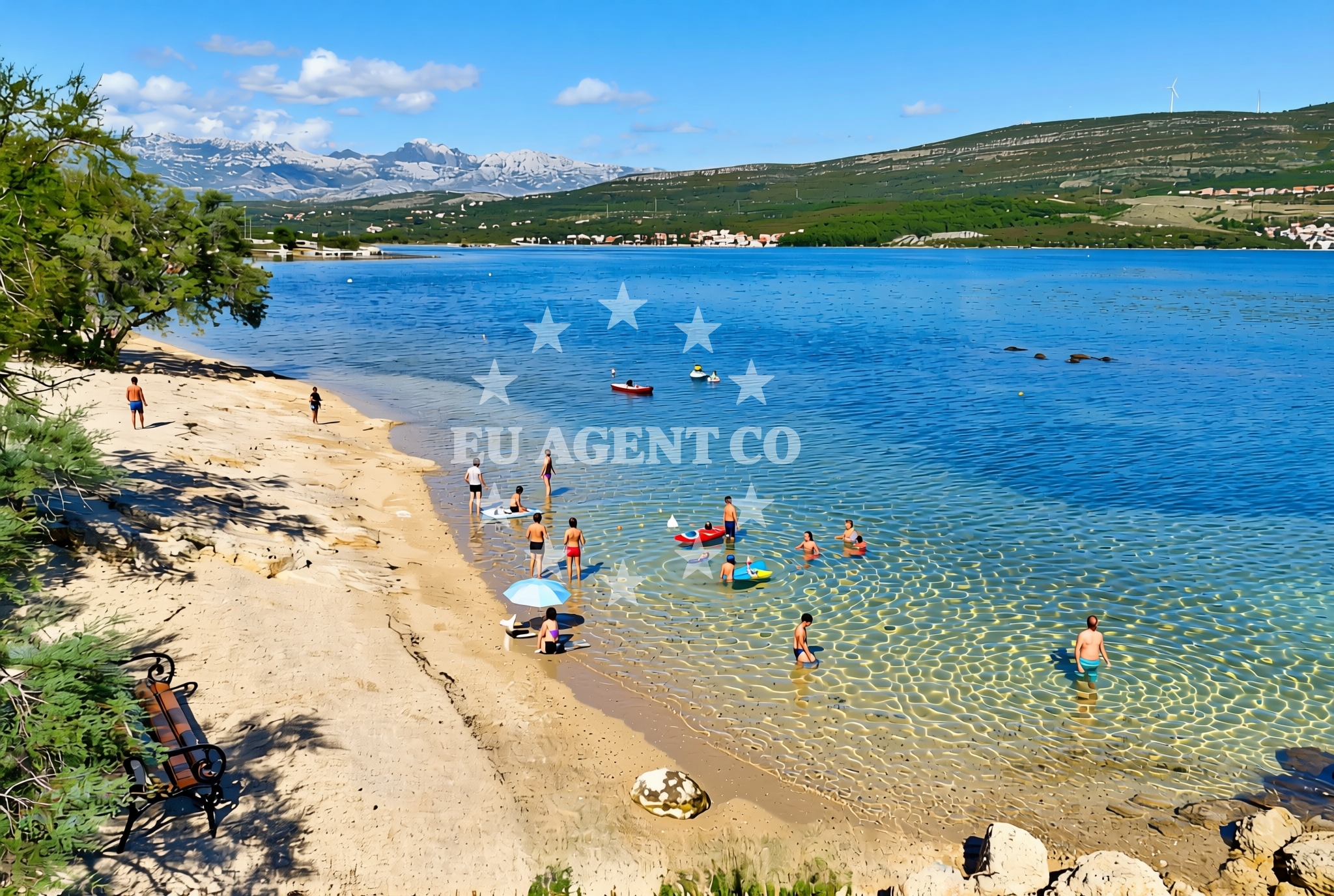
About this beach
Ćuskijaš sjever, Pridraga
Beach: Ćuskijaš sjever
Location: Pridraga
Characteristics and facilities
Gravel
80 m
Restaurant / snack bar
Caffe bar / Drinks stand
Natural shade
Beach character
The gravel composition of Ćuskijaš sjever is distinct, creating a textured walking surface that may appeal to those seeking a different coastal experience. While not ideal for swimming, the beach’s proximity to the sea allows for easy access to the water. The 80-meter length is modest, making it a quiet spot compared to larger public beaches in the region. The presence of a restaurant and caffe bar suggests a focus on casual dining rather than extensive recreational facilities. The natural shade provided by nearby trees or rock formations is a notable feature, particularly for visitors without personal sun protection.
Swimming and shore
The beach’s gravel shoreline may limit its suitability for swimming, though the shallow waters near the shore could be accessible for wading. The lack of explicit information on water quality or depth means visitors should approach the sea with caution. The shore itself is defined by its rocky and gravelly terrain, which may be uneven underfoot. This characterizes the beach as more of a transitional space between land and sea rather than a primary swimming destination.
Facilities and activities
On-site facilities include a restaurant, snack bar, and caffe bar, catering to basic dining needs. These amenities are likely operated on a seasonal basis, with no indication of year-round availability. The absence of structured activities or rental services means the beach is best suited for passive recreation, such as sunbathing or casual walks. The natural shade and proximity to refreshments make it a functional spot for short visits, though it lacks the infrastructure of more developed coastal areas.
Access and location
Ćuskijaš sjever is located in Pridraga, a coastal settlement in Croatia. The beach’s coordinates (44.147197, 15.600202) place it in a region known for its rugged coastline and smaller, less commercialized beaches. Access to the site is likely via local roads, though specific parking details are not provided. The beach’s position within Pridraga may mean it is part of a broader network of coastal trails or viewpoints, though no explicit connections to nearby settlements or landmarks are detailed in the catalog.
What to expect
Visitors to Ćuskijaš sjever should expect a gravel shoreline with limited recreational infrastructure. The beach is best described as a modest, low-key coastal spot rather than a destination for extensive water activities. The presence of a restaurant and caffe bar suggests it may be a regular stop for locals or those seeking a quiet meal with a view. The natural shade is a practical feature, though the beach’s overall appeal depends on personal preferences for less conventional coastal environments.
Practical tips
Given the gravel terrain, visitors may wish to wear sturdy footwear. The lack of detailed information on water conditions means caution is advised near the shore. The on-site dining options are likely seasonal, so confirming availability in advance is recommended.
Exploring the coast by yacht
The surrounding area of Pridraga is part of Croatia’s Adriatic coastline, a region popular with yacht charter guests due to its sheltered bays and scenic routes. Euro-Agent offers yacht charters in this area, allowing visitors to explore nearby anchorages and marinas. While Ćuskijaš sjever itself is not a designated marina or anchorage, its location provides a glimpse into the coastal landscapes that yacht charter guests might encounter during their voyages along the Croatian coast.
Regional Context
The settlement of Pridraga is part of the broader Dalmatian coast, known for its historical significance and natural beauty. The region is characterized by a mix of rocky shores, pine forests, and smaller fishing villages. While Ćuskijaš sjever is a modest beach, the area around Pridraga may offer opportunities for hiking, cycling, or exploring nearby cultural sites, though specific details are not detailed in the catalog.
Anchorages in the surrounding area
Anchorages in Karin, Novigrad, and Maslenica are located nearby, offering options for mooring in the surrounding area.
- Anchorage — karin — 1.3 NM from beach
- Karin dock — 1.3 NM from beach
- Anchorage — novigrad — 2.3 NM from beach
- Anchorage — maslenica — 3.8 NM from beach
- Anchorage — vinjerac — 8.9 NM from beach
- Anchorage — ljubac — 14.5 NM from beach
- Anchorage — ljubac — 14.6 NM from beach
- Anchorage — mrljane — pasman — 14.8 NM from beach
Distances are straight-line geographic distances, not sailing routes.
Mooring buoys in the surrounding area
- Buoy field — sukosan — 13.9 NM from beach
- Buoy field — sukosan — 14.0 NM from beach
- Jetty — ljubac — 14.9 NM from beach
- Crvena Luka jetty — 14.9 NM from beach
Distances are straight-line geographic distances, not sailing routes.
Marine fuel stations
- Fuel station — sukosan — 14.2 NM from beach
- Ina — biograd na moru — 14.3 NM from beach
- Ina — zadar — 16.1 NM from beach
- Ina — preko — ugljan — 18.0 NM from beach
Distances are straight-line geographic distances, not sailing routes.
Harbours in the surrounding area
- Obrovac — 4.8 NM from beach
- Maslenica — 5.1 NM from beach
- Vinjerac — 8.9 NM from beach
- Seline — 9.5 NM from beach
- Starigrad Paklenica — 11.3 NM from beach
- Sv. Filip and Jakov — sv filip and jakov — sveti filip i jakov — 13.5 NM from beach
Distances are straight-line geographic distances, not sailing routes.
Marinas in the surrounding area
- Dry dock marina Biograd — biograd na moru — 13.1 NM from beach
- Molum Marine Club — sveti filip i jakov — 13.6 NM from beach
- Marina Dalmacija — sukosan — 14.1 NM from beach
- Marina Kornati — biograd na moru — 14.1 NM from beach
- Marina Šangulin — marina sangulin — biograd na moru — 14.2 NM from beach
Distances are straight-line geographic distances, not sailing routes.
Navigation guides for the surrounding area
- Posedarje (Novigradsko More) — 6.3 NM from beach
- Starigrad-Paklenica {Velebitski Kanai) — 11.1 NM from beach
- Filip Jakov — 13.5 NM from beach
- Turanj — 13.6 NM from beach
- VELESITSKI KANAL (S) — 14.4 NM from beach
Distances are straight-line geographic distances, not sailing routes.
Yachts from nearby departure bases
Sailing yachts
- Oceanis 38.1 (ELSA) — Sukošan Marina Dalmacija — 14.1 NM from departure base to beach
Catamarans
- Lagoon 440 (LAGOSTA) — Sukošan Marina Dalmacija — 14.1 NM from departure base to beach
Motor yachts
- Prestige 46 Fly (ANIMA MARIS) — Sukošan Marina Dalmacija — 14.1 NM from departure base to beach
Motor boats
- Merry Fisher 795 () — Novigrad Dalmatia — 3.1 NM from departure base to beach
- Merry Fisher 695 — Sukošan Brodogradilište Filipi — 13.8 NM from departure base to beach
- Quicksilver Activ 555 — Sukošan Brodogradilište Filipi — 13.8 NM from departure base to beach
- Zar 61 Suite (Tucepi) — Sukošan Brodogradilište Filipi — 13.8 NM from departure base to beach
- Zar 65 Suite — Sukošan Brodogradilište Filipi — 13.8 NM from departure base to beach
- Elan 650 (Biokovo) — Sukošan Brodogradilište Filipi — 13.8 NM from departure base to beach
- Zar 57 WD — Sukošan Brodogradilište Filipi — 13.8 NM from departure base to beach
Distances are straight-line geographic distances, not sailing routes.