Cesarica Beach, Croatia
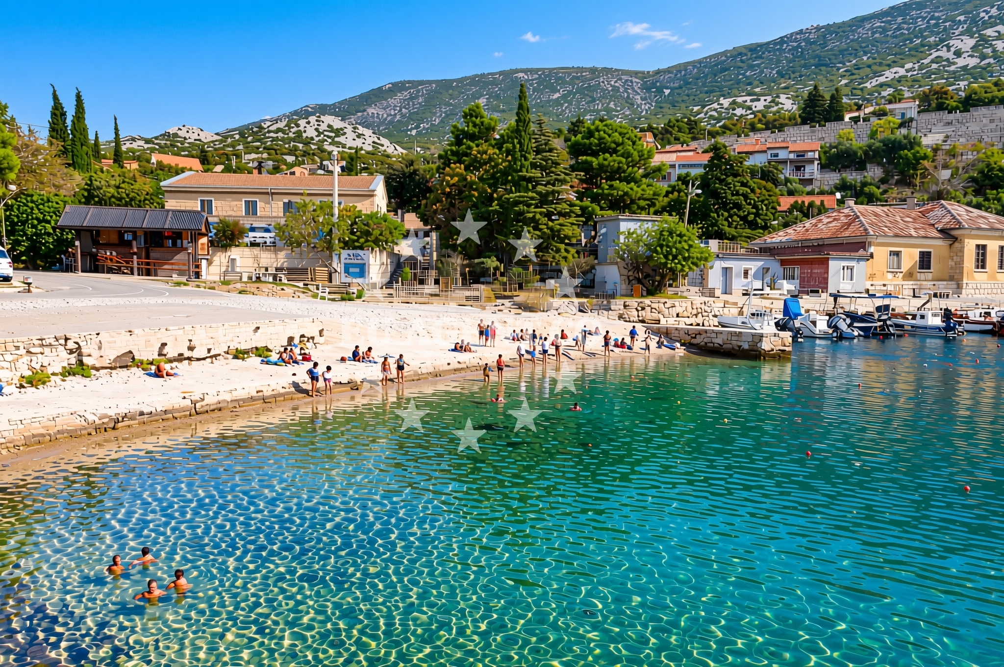
Cesarica Beach is a distinctive shoreline located in the village of Cesarica on Croatia’s Adriatic coast. This beach is characterized by its gravel and concrete/stone slab surfaces, offering a stark contrast to the typical sandy beaches found along the Croatian coast. While not ideal for swimming, its unique terrain makes it a notable feature for visitors exploring the region’s diverse coastal landscapes.
About this beach
Cesarica, Cesarica
Beach: Cesarica
Location: Cesarica
Characteristics and facilities
Gravel, concrete / stone slabs
Beach character
The beach’s surface consists primarily of gravel and stone slabs, which may appeal to those seeking a more rugged or unconventional shoreline experience. This composition suggests the beach is likely part of a rocky or transitional coastline, possibly near a headland or coastal pathway. The lack of traditional sandy beaches means visitors should expect a surface that may be less comfortable for prolonged sunbathing but could be suitable for walking or photography opportunities.
Swimming and shore
Due to its gravelly and rocky nature, Cesarica Beach is not well-suited for swimming or water-based activities. The shoreline appears to be more of a transitional area between land and sea, potentially serving as a path or access point rather than a recreational beach. Visitors interested in swimming may need to seek out nearby sandy beaches in the Cesarica area or along the broader Adriatic coast.
Facilities and activities
No specific facilities or amenities are listed for Cesarica Beach itself. Given its surface characteristics, it is unlikely to feature standard beach infrastructure such as showers, umbrellas, or sunbeds. However, the broader Cesarica village and surrounding region may offer accommodations, restaurants, or other services that could complement a visit to this unique shoreline.
Access and location
Cesarica Beach is located in the village of Cesarica, a small coastal settlement on the Adriatic Sea. The exact coordinates (44.563603° N, 15.020744° E) place it in a region known for its rugged coastline and historic sites. Travelers arriving by car may find access via local roads connecting to the village, though specific parking details are not available in the beach catalog. The area’s proximity to the Adriatic makes it a potential waypoint for yacht charter guests exploring the Dalmatian coast.
What to expect
Cesarica Beach offers a unique coastal experience defined by its gravel and stone slab surfaces. Visitors should expect a shoreline that is more suited to walking or photography than traditional sunbathing or swimming. The beach’s location in Cesarica village places it within a region rich in Adriatic coastal scenery, with opportunities to explore nearby settlements, historic sites, and natural landscapes. While the beach itself lacks conventional amenities, the surrounding area may provide accommodations and services for visitors.
Practical tips
Visitors to Cesarica Beach should consider wearing sturdy footwear to navigate the gravel and stone surfaces comfortably. Given the absence of detailed facility information, it is advisable to check with local providers in Cesarica village for nearby amenities such as refreshments, accommodations, or guided tours of the region.
Exploring the coast by yacht
For yacht charter guests, Cesarica Beach’s location on the Adriatic Sea places it within a sailing region renowned for its clear waters, historic ports, and scenic coastal routes. While the beach itself is not a typical anchorage or marina, the broader Dalmatian coast offers numerous ports and harbors suitable for yacht mooring. Charter guests exploring this area may find opportunities to dock in nearby villages or use anchorages along the coast for land excursions.
Historical and Cultural Context
The village of Cesarica is part of the Split-Dalmatia County in Croatia, an area with a rich history dating back to Roman times. The region is dotted with archaeological sites, medieval fortresses, and scenic coastal trails, reflecting its long-standing role as a crossroads of Mediterranean cultures. Visitors interested in history may find nearby attractions such as the ancient Roman city of Salona or the fortress of Klis worth exploring.
Anchorages in the surrounding area
Nearby anchorages include Uvala Prizna and several in Cesarica.
- Anchorage — cesarica — 0.1 NM from beach
- Anchorage — cesarica — 0.4 NM from beach
- Anchorage — cesarica — 1.0 NM from beach
- Anchorage — prizna — 2.9 NM from beach
- Anchorage — novalja — pag — 4.4 NM from beach
- Anchorage — prizna — 4.8 NM from beach
- Anchorage — pag — 4.9 NM from beach
- Anchorage — pag — 5.1 NM from beach
Distances are straight-line geographic distances, not sailing routes.
Mooring buoys in the surrounding area
- Jetty — zubovici — pag — 3.0 NM from beach
- Jetty — zubovici — pag — 3.1 NM from beach
- Buoy field — novalja — pag — 6.2 NM from beach
- Jetty — simuni — pag — 6.5 NM from beach
- Drljanda — stara novalja — pag — 6.8 NM from beach
Distances are straight-line geographic distances, not sailing routes.
Marine fuel stations
Fuel stations are located in Rab and Mali Losinj.
- Ina — rab — 16.1 NM from beach
- Ina — mali losinj — 23.9 NM from beach
- Adria Oil — mali losinj — 24.2 NM from beach
- Tifon — nerezine — losinj — 27.4 NM from beach
Distances are straight-line geographic distances, not sailing routes.
Harbours in the surrounding area
Harbors in the area include Prizna, Pag, and Karlobag.
- Karlobag — 3.2 NM from beach
- Prizna — 3.2 NM from beach
- Žigljen — zigljen — pag — 3.2 NM from beach
- Novalja — pag — 6.2 NM from beach
- Stara Novalja — pag — 6.5 NM from beach
- Pag — 7.3 NM from beach
Distances are straight-line geographic distances, not sailing routes.
Marinas in the surrounding area
Marinas are situated in Simuni, Rab, and Mali Lošinj.
- ACI Marina Šimuni — simuni — pag — 6.3 NM from beach
- ACI Marina Rab — 16.0 NM from beach
- ACI Marina Supetarska Draga — rab — 19.1 NM from beach
- Y/C Marina Mali Lošinj — mali losinj — 24.0 NM from beach
- Marina Lošinj — mali losinj — 24.2 NM from beach
Distances are straight-line geographic distances, not sailing routes.
Navigation guides for the surrounding area
Navigation guides cover Uvala Prizna and other nearby locations.
- Uvala Prizna — 3.1 NM from beach
- Caska — 4.2 NM from beach
- Novalja — 5.8 NM from beach
- Uvala Bliznica — 7.3 NM from beach
- Uvala Zavratnica — 9.6 NM from beach
Distances are straight-line geographic distances, not sailing routes.
Yachts from nearby departure bases
Yachts depart from bases in Novalja, Šimuni, Pag, Rab, and Mali Lošinj.
Sailing yachts
- First 45 (Egeria) — Šimuni Kolan ACI Marina — 6.2 NM from departure base to beach
- Elan 40 Impression (Laali) — Mali Lošinj — 24.0 NM from departure base to beach
- Bavaria 46 Cruiser (DEA) — Mali Lošinj — 24.0 NM from departure base to beach
Motor yachts
- Absolute 50 Fly (Acrobat) — Rab ACI Marina — 16.0 NM from departure base to beach
Motor boats
- Balt 818 Titanium (Valentina) — Novalja — 6.0 NM from departure base to beach
- Balt 818 Titanium (Valentina 2) — Novalja — 6.0 NM from departure base to beach
- BWA Sport 22GT (BWA ) — Pag City Port — 7.3 NM from departure base to beach
- Merry Fisher 895 — Povljana Marina — 13.4 NM from departure base to beach
- Galeon Galia 630 (287670ML) — Mali Lošinj — 24.0 NM from departure base to beach
- Galeon Galia 630 blue — Mali Lošinj — 24.0 NM from departure base to beach
Distances are straight-line geographic distances, not sailing routes.