Bunarići Zapad, Maslenica Beach, Croatia
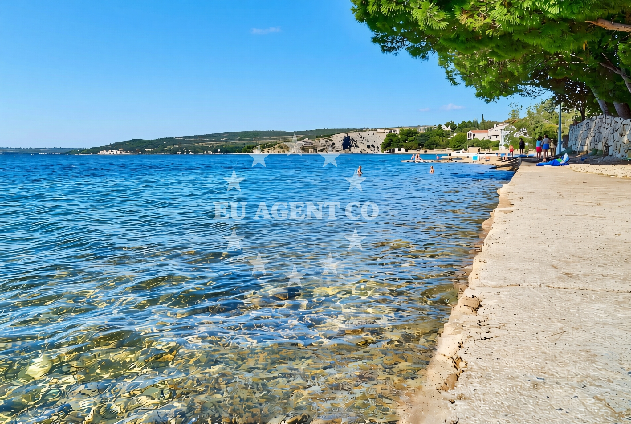
About this beach
Bunarići zapad, Maslenica
Beach: Bunarići zapad
Location: Maslenica
Characteristics and facilities
Gravel, concrete / stone slabs
50 m
Natural shade
Beach character
The beach's surface is primarily composed of gravel and concrete/stone slabs, creating a firm walking surface that contrasts with the typical sandy shores of the region. The 50-meter stretch of natural shade, likely provided by coastal rock formations or vegetation, offers a respite from direct sunlight. This beach appears to be part of a larger coastal system where the terrain shapes the shoreline, influencing both the visual character and the practical use of the area. The absence of formal facilities means the beach retains its natural state, appealing to those who prefer minimal intervention in their coastal experiences.Swimming and shore
The beach's gravel and stone composition may affect swimming conditions, though specific water depth or wave patterns are not documented. The shore's firm surface could make it suitable for walking or light recreational activities, though the lack of amenities suggests it is not designed for extended stays. The natural shade provides a practical benefit for visitors seeking protection from the sun during peak hours.Facilities and activities
No formal facilities are listed for Bunarići Zapad, Maslenica Beach. The absence of amenities such as showers, restrooms, or seating indicates that the beach is likely used for brief visits rather than extended stays. Activities appear to be limited to what the natural environment allows, such as walking along the shoreline or enjoying the shaded areas. The beach's character suggests it may be more suitable for those seeking a quiet, unstructured coastal experience.Access and location
Located in Maslenica, a coastal area in Croatia, this beach is part of a region known for its dramatic cliffs and maritime history. The exact access route is not detailed in the catalog, but the beach's proximity to Maslenica implies it may be reachable via local roads or paths. The surrounding area is part of a larger coastal landscape that includes both natural and historical sites, though specific nearby attractions are not mentioned in the beach's documentation.What to expect
Visitors to Bunarići Zapad, Maslenica Beach should expect a shoreline defined by gravel and stone slabs, with a naturally shaded section offering relief from the sun. The beach's lack of formal facilities means it is best suited for short visits, with no amenities such as restrooms, showers, or seating available. The area's raw, unmodified character makes it an appealing destination for those seeking a connection with the natural coastline, though it may not be ideal for families requiring extensive infrastructure.Practical tips
Given the beach's gravel and stone surface, visitors may want to wear sturdy footwear for walking along the shore. The natural shade can be a valuable feature during hot weather, but visitors should still bring sun protection as the beach's exposure to sunlight can vary. The absence of formal facilities means planning for self-sufficiency is essential.Exploring the coast by yacht
For yacht charter guests exploring the Croatian coast, Bunarići Zapad lies within a region known for its dramatic coastal landscapes and historic maritime routes. The nearby area of Maslenica is part of a sailing region that includes the famous Maslenica Strait, a narrow passage between the islands of Brač and Hvar. While the beach itself is not a formal anchorage, the surrounding waters are part of a sailing route that connects to major marinas in the region, including those in Split and Hvar. Charter guests may find the area useful for short sailing excursions or as a reference point when navigating the southern Adriatic.Regional Coastal Context
Maslenica is situated in the Split-Dalmatia County, a region with a rich maritime history and a network of coastal towns. The area is known for its rugged coastline, which includes cliffs, caves, and islands that have shaped the region's sailing routes for centuries. Nearby, the town of Maslenica itself is a small settlement with connections to the Adriatic's historic trade routes. The beach's location reflects the broader pattern of coastal access in this part of Croatia, where natural features often dictate the placement of beaches and maritime activities.Anchorages in the surrounding area
Anchorages near Maslenica include the nearby Maslenica anchorage and others in Vinjerac, Karin, and Ljubac.
- Anchorage — maslenica — 1.3 NM from beach
- Anchorage — novigrad — 3.2 NM from beach
- Anchorage — vinjerac — 4.3 NM from beach
- Anchorage — karin — 5.7 NM from beach
- Karin dock — 6.0 NM from beach
- Anchorage — ljubac — 10.9 NM from beach
- Anchorage — ljubac — 11.0 NM from beach
- Anchorage — rtina — 11.4 NM from beach
Distances are straight-line geographic distances, not sailing routes.
Mooring buoys in the surrounding area
Mooring buoys in the area include the jetty in Ljubac and buoy fields in Sukosan.
- Jetty — ljubac — 11.2 NM from beach
- Šibuljina Point — sibuljina point — 11.4 NM from beach
- Buoy field — sukosan — 14.4 NM from beach
- Buoy field — sukosan — 14.5 NM from beach
Distances are straight-line geographic distances, not sailing routes.
Marine fuel stations
- Fuel station — sukosan — 14.6 NM from beach
- Ina — zadar — 14.9 NM from beach
- Ina — preko — ugljan — 17.4 NM from beach
- Ina — biograd na moru — 17.4 NM from beach
Distances are straight-line geographic distances, not sailing routes.
Harbours in the surrounding area
Harbors in the vicinity include the nearby Maslenica harbor and others in Vinjerac, Seline, and Obrovac.
- Maslenica — 0.3 NM from beach
- Vinjerac — 4.3 NM from beach
- Seline — 4.7 NM from beach
- Obrovac — 6.0 NM from beach
- Starigrad Paklenica — 6.5 NM from beach
- Ražanac — razanac — 9.4 NM from beach
Distances are straight-line geographic distances, not sailing routes.
Marinas in the surrounding area
- Marina Dalmacija — sukosan — 14.5 NM from beach
- Marina Zadar — 14.9 NM from beach
- Vitrenjak Zadar — 15.2 NM from beach
- Marina Borik — zadar — 15.4 NM from beach
- Dry dock marina Biograd — biograd na moru — 16.2 NM from beach
Distances are straight-line geographic distances, not sailing routes.
Restaurants near the beach
Restaurants in Seline provide dining options close to the beach.
- Gostionica Ivan — seline — 4.4 NM from beach
- Restaurant — seline — 4.6 NM from beach
Distances are straight-line geographic distances, not sailing routes.
Navigation guides for the surrounding area
Navigation guides for Posedarje, Starigrad-Paklenica, and the Velebitski Kanal aid route planning.
- Posedarje (Novigradsko More) — 2.9 NM from beach
- Starigrad-Paklenica {Velebitski Kanai) — 6.3 NM from beach
- VELESITSKI KANAL (S) — 9.9 NM from beach
- KrusCica and Uvala KrusCica Duboka — 12.4 NM from beach
Distances are straight-line geographic distances, not sailing routes.
Yachts from nearby departure bases
Sailing yachts
- Bavaria Cruiser 40 (Slava) — Sukošan Marina Dalmacija — 14.5 NM from departure base to beach
Catamarans
- Lagoon 42 (DALMATIA SUNRISE ) — Sukošan Marina Dalmacija — 14.5 NM from departure base to beach
Motor yachts
- Manhattan 50 (FOREVER MAJA) — Sukošan Marina Dalmacija — 14.5 NM from departure base to beach
Motor boats
- Merry Fisher 795 () — Novigrad Dalmatia — 2.2 NM from departure base to beach
- Merry Fisher 695 — Sukošan Brodogradilište Filipi — 14.3 NM from departure base to beach
- Elan 650 (Biokovo) — Sukošan Brodogradilište Filipi — 14.3 NM from departure base to beach
- Zar 57 WD — Sukošan Brodogradilište Filipi — 14.3 NM from departure base to beach
- Quicksilver Activ 555 — Sukošan Brodogradilište Filipi — 14.3 NM from departure base to beach
- Zar 61 Suite (Tucepi) — Sukošan Brodogradilište Filipi — 14.3 NM from departure base to beach
- Zar 65 Suite — Sukošan Brodogradilište Filipi — 14.3 NM from departure base to beach
Distances are straight-line geographic distances, not sailing routes.