Broce Beach, Croatia
4 photos
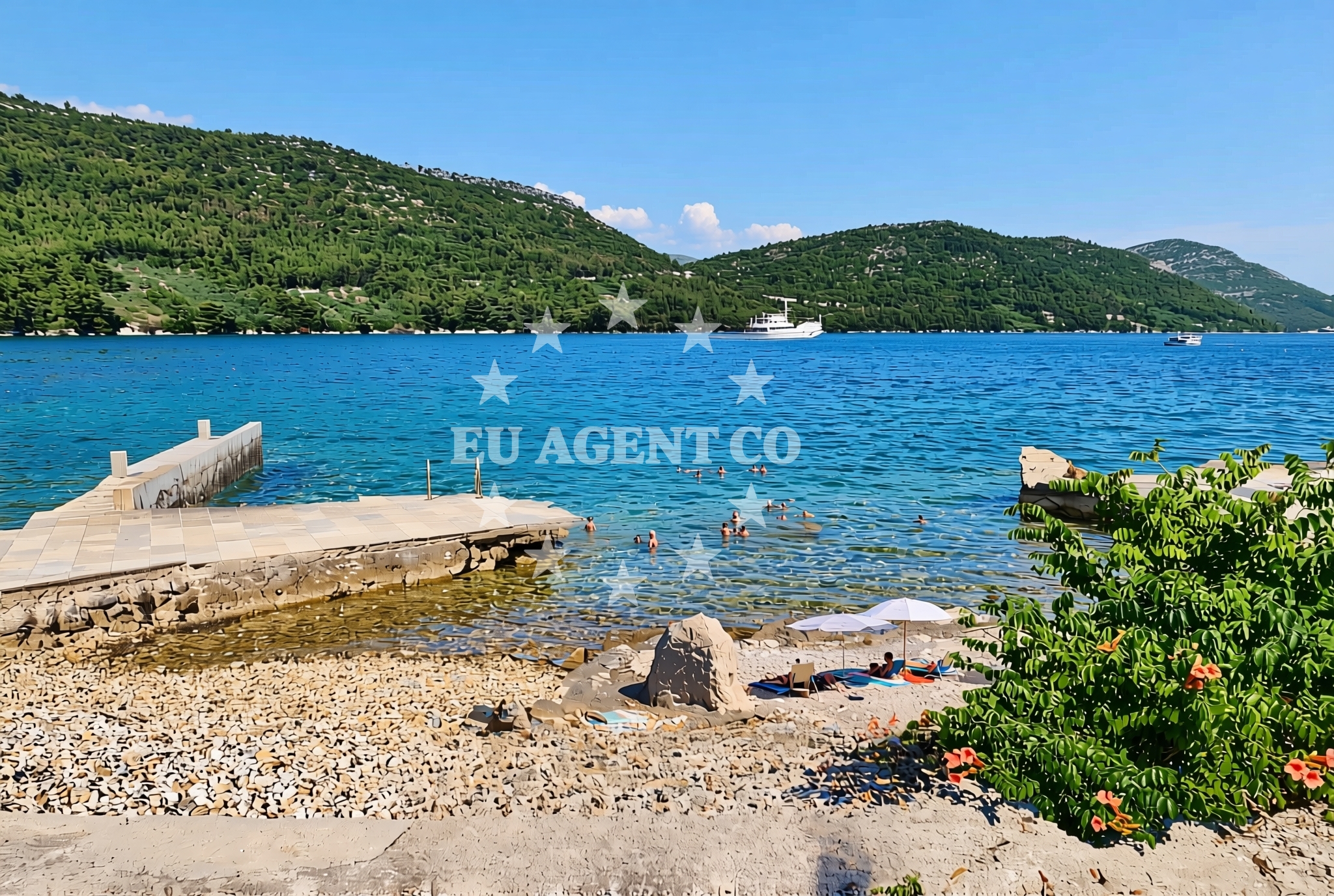
About this beach
Broce jug, Broce
Beach: Broce jug
Location: Broce
Characteristics and facilities
Pebbles, gravel, concrete / stone slabs, rocks
120 m
Natural shade
Beach character
The beach consists primarily of pebbles, gravel, and concrete/stone slabs, with exposed rock surfaces along parts of the shoreline. Natural shade is available from overhanging rock formations, providing limited relief from direct sunlight. The beach's composition suggests it is more suited for casual exploration than swimming, though the Adriatic's generally calm waters in this area may permit wading during low tide. The 120-meter length is relatively short, with the shoreline tapering toward the river's mouth.Swimming and shore
Swimming conditions at Broce Beach are not explicitly documented in the catalog. The pebbly and rocky terrain may make entry into the water challenging, though the Adriatic Sea's typically mild currents in this region could allow for wading during low tide. The shore's composition suggests it is more suited for walking along the water's edge than for recreational swimming. Visitors should be mindful of tidal patterns and potential slipperiness on wet rock surfaces.Facilities and activities
No structured facilities or activities are listed for Broce Beach. The absence of amenities such as showers, restrooms, or lifeguard services suggests it is an unmanaged shoreline. General activities may include sunbathing on the rocky outcrops, exploring the nearby river mouth, or walking along the coast. The beach's proximity to the Cetina River and surrounding hills offers opportunities for hiking or cycling in the broader area.Access and location
Broce Beach is located in the village of Broce, approximately 30 kilometers northeast of Split and 150 kilometers southeast of Dubrovnik. The beach is accessible via local roads connecting Broce to the main Dalmatian coast highway (A1). The nearby Cetina River creates a natural boundary, with the beach situated at the river's mouth. The area is part of the Split-Dalmatia County, a region known for its historic sites, vineyards, and coastal sailing routes.What to expect
Broce Beach is a short, pebble-strewn shoreline with natural rock formations providing limited shade. The beach is not equipped with amenities such as restrooms, showers, or lifeguard services. Visitors should expect a rugged coastline suitable for walking along the water's edge rather than swimming. The area's proximity to the Cetina River and surrounding hills offers opportunities for exploring the broader landscape, though the beach itself is not a focal point for structured recreation.Practical tips
Visitors should bring water, sunscreen, and comfortable footwear for navigating the pebbly and rocky terrain. The lack of amenities means provisions should be brought from Broce village. Tidal patterns may affect access to the shoreline, and caution is advised on wet rock surfaces. The beach's location near the Cetina River could offer scenic walking routes along the riverbank.Exploring the coast by yacht
Broce Beach lies within the Split-Dalmatia sailing region, a popular area for motor and sailing yacht charters. The nearby Adriatic Sea offers opportunities for anchoring in sheltered bays or marinas along the coast. Euro-Agent Yacht Charter can assist with bookings for vessels exploring this area, with options to anchor near Broce or sail to nearby ports such as Split or Šibenik. The beach's proximity to the Cetina River may also provide a scenic stop for yachts traveling along the Dalmatian coast.Regional Context
The Broce area is part of the Split-Dalmatia County, known for its historic monasteries, vineyards, and coastal scenery. The nearby village of Broce is a small settlement with limited tourism infrastructure, focusing on agriculture and local crafts. The Cetina River, which flows near the beach, is a popular destination for rafting and kayaking, though these activities are not directly associated with Broce Beach itself.Anchorages in the surrounding area
- Ribnja — broce — 1.1 NM from beach
- Anchorage — broce — 1.2 NM from beach
- Anchorage — broce — 1.4 NM from beach
- Anchorage — broce — 1.8 NM from beach
- Anchorage — mali ston — 1.8 NM from beach
- Anchorage — prapratno — 1.9 NM from beach
- Anchorage — broce — 3.1 NM from beach
- Anchorage — olipa — 4.0 NM from beach
Distances are straight-line geographic distances, not sailing routes.
Mooring buoys in the surrounding area
- Quay — kobas — 1.4 NM from beach
- Lukas Taverna jetty — kobas — 1.4 NM from beach
- Konoba Nico jetty — kobas — 1.4 NM from beach
- Quay — prapratno — 1.9 NM from beach
- Restaurant Maran quay — okuklje — mljet — 5.9 NM from beach
Distances are straight-line geographic distances, not sailing routes.
Marine fuel stations
- Fuel station — sobra — mljet — 6.4 NM from beach
- Ina — dubrovnik — 18.6 NM from beach
- Fuel station — ploce — 18.7 NM from beach
- Ina — dubrovnik — 20.0 NM from beach
Distances are straight-line geographic distances, not sailing routes.
Harbours in the surrounding area
- Ston — 1.3 NM from beach
- Prapranto Ferry Harbour — prapratno — 1.8 NM from beach
- Mali Ston — 1.8 NM from beach
- Hodilje — 2.7 NM from beach
- Doli — 3.4 NM from beach
- Okuklje — mljet — 5.9 NM from beach
Distances are straight-line geographic distances, not sailing routes.
Marinas in the surrounding area
- ACI Marina Slano — 7.8 NM from beach
- Marina Frapa Dubrovnik — 18.7 NM from beach
- ACI Marina Dubrovnik — 20.0 NM from beach
- Marina Lumbarda — korcula — 24.9 NM from beach
- ACI Marina Korčula — korcula — 26.9 NM from beach
Distances are straight-line geographic distances, not sailing routes.
Restaurants near the beach
- Gastro Mare — kobas — 1.4 NM from beach
- Luka's Taverna — lukas taverna — kobas — 1.4 NM from beach
- Nico — kobas — 1.4 NM from beach
- Bota Sare — mali ston — 1.8 NM from beach
- Restaurant — prapratno — 1.9 NM from beach
Distances are straight-line geographic distances, not sailing routes.
Navigation guides for the surrounding area
- Broce — 0.2 NM from beach
- Excursions — 1.3 NM from beach
- Mali Ston — 1.7 NM from beach
- Hodilje — 2.6 NM from beach
- Luka — 3.0 NM from beach
Distances are straight-line geographic distances, not sailing routes.
Yachts from nearby departure bases
Sailing yachts
- Oceanis 45 (Mambo 1) — Slano ACI Marina — 7.8 NM from departure base to beach
- Elan 45 Impression (Skyfall) — Slano ACI Marina — 7.8 NM from departure base to beach
- Elan 50 Impression (Timeless) — Slano ACI Marina — 7.8 NM from departure base to beach
- Oceanis 45 (Cancan) — Slano ACI Marina — 7.8 NM from departure base to beach
- Oceanis 45 (Soul) — Slano ACI Marina — 7.8 NM from departure base to beach
Catamarans
- Lagoon 42 (MALA KATE I) — Slano ACI Marina — 7.8 NM from departure base to beach
- Lagoon 42 (HAPPY KEY) — Slano ACI Marina — 7.8 NM from departure base to beach
- Helia 44 (Lounge) — Slano ACI Marina — 7.8 NM from departure base to beach
- Lagoon 450 Flybridge (ANJA I) — Slano ACI Marina — 7.8 NM from departure base to beach
- Lagoon 450 Flybridge (MALA MARE) — Slano ACI Marina — 7.8 NM from departure base to beach
Distances are straight-line geographic distances, not sailing routes.
Frequently asked questions
Is Broce Beach suitable for swimming?
The beach's pebbly and rocky terrain suggests it is not ideal for swimming. The Adriatic Sea's generally calm waters in this area may permit wading during low tide, but the shoreline is more suited for walking along the water's edge.Are there facilities at Broce Beach?
No structured facilities such as restrooms, showers, or lifeguard services are listed for Broce Beach. Visitors should bring provisions from Broce village.Nearby beaches
Broce sredina, Broce Beach
Broce sredina
0.1 km
Broce: beaches and coves (7)
Broce
0.3 km
Broce sjever, Broce Beach
Broce sjever
0.3 km
Lukobran, Broce Beach
Lukobran
0.4 km
Marinica istok, Ston Beach
Marinica istok
0.5 km
Marinica sredina, Ston Beach
Marinica sredina
0.5 km
Marinica zapad, Ston Beach
Marinica zapad
0.6 km
Maslina, Zamaslina Beach
Maslina
1.0 km