Batalaža jug, Ugljan (Ugljan) Beach, Croatia
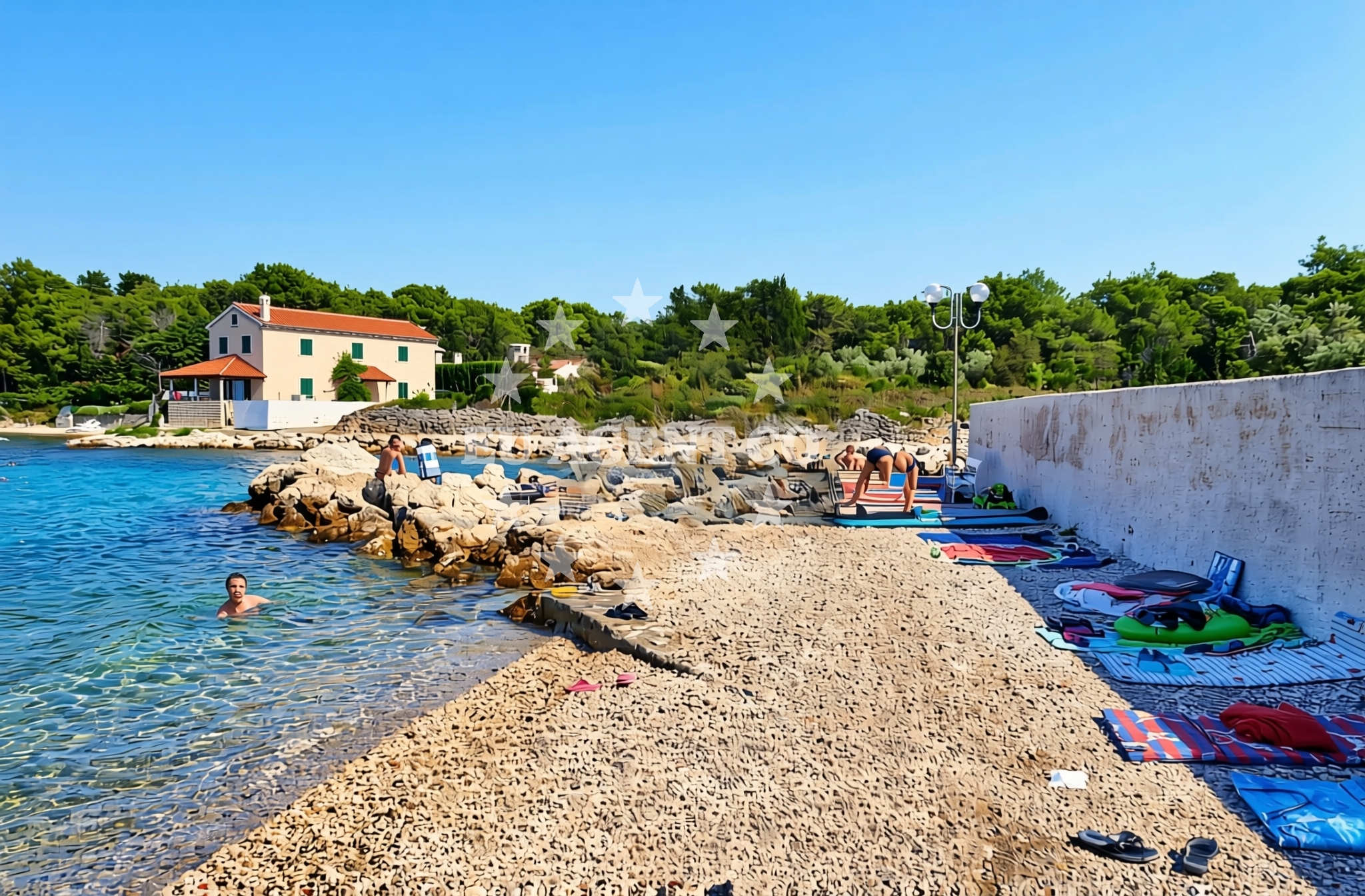
About this beach
Batalaža jug, Ugljan (Ugljan)
Beach: Batalaža jug
Location: Ugljan (Ugljan)
Characteristics and facilities
Gravel, concrete / stone slabs, rocks
Restaurant / snack bar
Caffe bar / Drinks stand
Natural shade
shower
Changing cabin
Beach character
The beach’s surface is composed of gravel, concrete slabs, and exposed rock formations, creating a rugged yet accessible environment. While not ideal for sunbathing on soft sand, the terrain offers a stable base for walking and exploring the shoreline. Natural shade is available in certain areas, providing respite from the sun. The beach’s character reflects the geological features of Ugljan, an island known for its limestone cliffs and coastal caves.Swimming and shore
Swimming conditions at Batalaža jug are influenced by the surrounding rocky terrain, which can create uneven water depths and occasional currents. The shoreline is generally accessible, though visitors should exercise caution near the rocky sections. The beach’s position on Ugljan’s southern coast means it benefits from the Adriatic’s generally calm waters during the summer months, though weather patterns can affect conditions.Facilities and activities
Basic facilities include a restaurant/snack bar and a café bar/drinks stand, catering to visitors seeking refreshments. A shower and changing cabin are available for those wishing to freshen up before or after water activities. While no structured activities are listed, the beach’s proximity to Ugljan’s coastal trails and caves offers opportunities for hiking and exploration.Access and location
Batalaža jug is situated on Ugljan, a small island southeast of Hvar and northwest of Brac. The nearest major town is Stari Grad on Hvar, accessible by ferry or boat. The beach’s location within Ugljan’s southern coastline places it near the island’s historic sites, including ancient Roman ruins and traditional stone houses. Visitors arriving by yacht may find anchorage options in nearby bays, though specific details should be confirmed through local maritime resources.What to expect
Expect a beach experience defined by its gravel and rocky terrain, with amenities focused on basic needs rather than luxury. The presence of a restaurant, café, shower, and changing cabin ensures visitors can enjoy meals and prepare for water activities. The beach’s setting on Ugljan offers a quieter alternative to more tourist-heavy areas of the Dalmatian coast, with opportunities to explore the island’s cultural and natural landmarks.Practical tips
Bring sturdy footwear for navigating the gravel and rocky areas. The available changing cabin and shower make it suitable for those planning to swim or engage in water-based activities. Given the lack of extensive facilities, consider bringing personal items like sunscreen or picnic supplies.Exploring the coast by yacht
For sailors and yacht charter guests, the surrounding area of Ugljan and the broader Hvar-Brac archipelago offers a rich sailing environment. The Adriatic’s clear waters and consistent winds make this region a popular choice for motor yacht and sailboat charters. Euro-Agent can assist in arranging yacht rentals in the area, with options to explore nearby anchorages, historic ports, and scenic coastal routes.Cultural Context of Ugljan
Ugljan, like many Dalmatian islands, has a history tied to fishing and agriculture. The island’s traditional stone houses and olive groves reflect its rural character. Visitors may explore local wineries or sample regional dishes like black risotto, a specialty of the area.Anchorages in the surrounding area
Anchorages nearby include Ugljan and Ceprljanda, offering convenient mooring options close to the beach.
- Anchorage — ugljan — 0.0 NM from beach
- Anchorage — ceprljanda — ugljan — 1.2 NM from beach
- Anchorage — muline — ugljan — 1.2 NM from beach
- Anchorage — muline — ugljan — 1.3 NM from beach
- Anchorage — ugljan — 1.8 NM from beach
- Anchorage — ugljan — 1.9 NM from beach
- Anchorage — ugljan — 2.0 NM from beach
- Anchorage — rivanj — 2.0 NM from beach
Distances are straight-line geographic distances, not sailing routes.
Mooring buoys in the surrounding area
- Jetty — ugljan — 0.1 NM from beach
- Buoy field — muline — ugljan — 1.3 NM from beach
- Buoy field Muline — ugljan — 1.3 NM from beach
- Punta Skala — petrcane — 3.9 NM from beach
- Jetty — iz veli — 4.8 NM from beach
Distances are straight-line geographic distances, not sailing routes.
Marine fuel stations
Fuel stations in Preko and Zadar supply marine fuel for vessels traveling to the beach area.
- Ina — preko — ugljan — 5.4 NM from beach
- Ina — zadar — 5.7 NM from beach
- Fuel station — sukosan — 9.9 NM from beach
- Ina — zaglav — dugi otok — 11.4 NM from beach
Distances are straight-line geographic distances, not sailing routes.
Harbours in the surrounding area
- Ugljan — 0.5 NM from beach
- Čeprljanda — ceprljanda — ugljan — 1.0 NM from beach
- Muline — ugljan — 1.2 NM from beach
- Lukoran — ugljan — 3.1 NM from beach
- Rivanj — 3.1 NM from beach
- Sutomišćica — sutomiscica — ugljan — 3.8 NM from beach
Distances are straight-line geographic distances, not sailing routes.
Marinas in the surrounding area
- Olive Island Marina — sutomiscica — ugljan — 3.9 NM from beach
- Marina Borik — zadar — 4.8 NM from beach
- Vitrenjak Zadar — 5.1 NM from beach
- Marina Preko — ugljan — 5.1 NM from beach
- Marina Veli Iž — iz veli — 5.1 NM from beach
Distances are straight-line geographic distances, not sailing routes.
Restaurants near the beach
- Trapula — ugljan — 0.4 NM from beach
- Kaleta — ugljan — 0.5 NM from beach
- Apollo — ugljan — 0.5 NM from beach
- Pizzaria Muline — ugljan — 1.1 NM from beach
- Stivon — muline — ugljan — 1.2 NM from beach
- Kažot — muline — ugljan — 1.2 NM from beach
- Olive Garden — sutomiscica — ugljan — 3.9 NM from beach
Distances are straight-line geographic distances, not sailing routes.
Navigation guides for the surrounding area
Navigation guides for Ugljan, Muline, and surrounding areas assist in planning routes to the beach.
- Ugljan — 0.7 NM from beach
- Muline — 1.1 NM from beach
- Ceprljanda — 1.3 NM from beach
- Lukoran Veli — 3.1 NM from beach
- Uvala Kablin — 3.7 NM from beach
Distances are straight-line geographic distances, not sailing routes.
Yachts from nearby departure bases
Sailing yachts
- Elan Impression 40 (Val) — Ugljan Sutomišćica Olive Island — 3.9 NM from departure base to beach
- Oceanis 40.1 — Zadar Marina Borik — 4.8 NM from departure base to beach
- Sun Odyssey 410 (Vague) — Zadar Marina Borik — 4.8 NM from departure base to beach
Catamarans
- Sunreef 60 (SINATA) — Zadar Marina Borik — 4.8 NM from departure base to beach
Motor yachts
- Prestige 460 (Adudu 2) — Zadar Marina Borik — 4.8 NM from departure base to beach
Motor boats
- Quicksilver Activ 905 (Galeb) — Ugljan Sutomišćica Olive — 3.9 NM from departure base to beach
- Rancraft RM21 (Dugi otok) — Zadar Diklo Port — 4.6 NM from departure base to beach
- Rancraft RM19 (Daycruiser) — Zadar Diklo Port — 4.6 NM from departure base to beach
- Rancraft RS Cinque.5 — Zadar Diklo Port — 4.6 NM from departure base to beach
- Axopar 37 ST Brabus — Zadar Marina Borik — 4.8 NM from departure base to beach
Distances are straight-line geographic distances, not sailing routes.