Badnjena Beach, Vela Luka (Korčula), Croatia
About this beach
Badnjena, Vela Luka (Korčula)
Beach: Badnjena
Location: Vela Luka (Korčula)
Characteristics and facilities
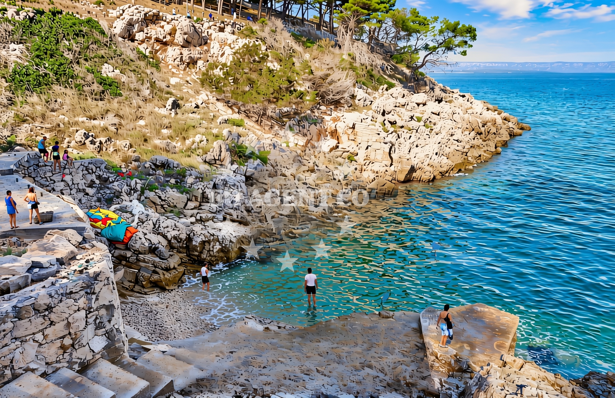
Gravel, concrete / stone slabs, rocks
Beach character
Badnjena Beach is defined by its gravelly and rocky shoreline, which contrasts with the more common sandy beaches found in the area. The surface consists of a mix of natural stone slabs and loose gravel, making it suitable for walking but less ideal for barefoot swimming. The beach's terrain is likely shaped by coastal erosion and the surrounding geology of Korčula. Its proximity to the sea creates a dynamic interplay between land and water, with waves and tides influencing the shoreline's appearance.Swimming and shore
Swimming conditions at Badnjena Beach depend on the immediate shoreline's topography. The rocky and gravelly areas may create uneven entry points into the water, potentially making it challenging for swimmers. However, the beach's natural features could offer opportunities for exploring tide pools or snorkeling in areas where the rocks form shallow, sheltered pockets. The Adriatic Sea's generally clear waters may enhance visibility for those interested in underwater exploration, though the beach itself does not have designated swimming zones or lifeguard services.Facilities and activities
There are no official facilities or amenities directly associated with Badnjena Beach, as indicated by the catalog data. Activities are limited to the natural environment, such as walking along the shoreline or observing the coastal landscape. Nearby Vela Luka, however, offers a range of services, including restaurants, shops, and accommodations, which may be accessible to visitors exploring the area. The beach's rocky terrain could also provide opportunities for photography or geological observation.Access and location
Badnjena Beach is situated within Vela Luka, a well-known coastal settlement on the island of Korčula. Access to the beach is likely via local roads or footpaths connecting to the town. Vela Luka itself is a popular destination on the Dalmatian coast, with ferry connections to other islands in the Adriatic, including Hvar and Brač. The beach's location makes it a potential stop for those exploring the Korčula region by land or sea.What to expect
Visitors to Badnjena Beach should expect a natural, undeveloped shoreline with gravel, concrete slabs, and rocks. The beach lacks traditional amenities such as sunbeds, umbrellas, or changing facilities. Those planning to visit should consider the terrain when selecting footwear and be prepared for a more rugged coastal experience. The area's proximity to Vela Luka means that visitors can access nearby services and accommodations, though the beach itself remains a quiet, less commercialized spot.Practical tips
Due to the beach's rocky and gravelly surface, visitors may want to wear sturdy shoes for walking along the shoreline. Sun protection is recommended, as the lack of shade means exposure to the sun may be more direct. Those interested in swimming should be mindful of the uneven entry points into the water. The beach's location within Vela Luka allows for easy access to local amenities, which can be useful for meals or rest.Exploring the coast by yacht
For yacht charter guests exploring the Adriatic, Badnjena Beach is part of the broader sailing area around Korčula. The island is a common destination for charter yachts, offering a mix of natural beauty and cultural attractions. Nearby anchorages and marinas in Vela Luka provide convenient options for docking, and the surrounding waters are known for their scenic routes to other Dalmatian islands. While Badnjena Beach itself is not a designated anchorage, its proximity to Vela Luka makes it a potential landing point for shore excursions during a charter voyage.Regional Context: Korčula's Coastal Landscape
Korčula, often referred to as the 'Island of Hundred Towns,' is characterized by its rugged coastline, medieval towns, and fertile hinterlands. The island's southern coast, where Vela Luka is located, features a mix of pebbly beaches and cliffs, reflecting the region's geological history. This landscape is typical of the Dalmatian coast, where natural formations often take precedence over artificial beach developments. Yacht charter guests may find the area particularly appealing for its combination of cultural heritage and unspoiled natural scenery.Anchorages in the surrounding area
Anchorages in the surrounding area include Gradina and other locations in Vela Luka and Korčula.
- Gradina — vela luka — korcula — 2.6 NM from beach
- Anchorage — vela luka — korcula — 3.7 NM from beach
- Anchorage — korcula — 3.7 NM from beach
- Anchorage — vela luka — korcula — 4.2 NM from beach
- Karbuni — zvirinovic — 4.3 NM from beach
- Anchorage — vela luka — korcula — 4.3 NM from beach
- Anchorage — vela luka — korcula — 4.4 NM from beach
- Anchorage — vela luka — korcula — 4.6 NM from beach
Distances are straight-line geographic distances, not sailing routes.
Mooring buoys in the surrounding area
- Buoy field — vela luka — korcula — 1.5 NM from beach
- Gradina buoy field — vela luka — korcula — 2.7 NM from beach
- Jetty — vela luka — korcula — 4.3 NM from beach
- Quay — vela luka — korcula — 4.7 NM from beach
- Jetty — proizd — 5.1 NM from beach
Distances are straight-line geographic distances, not sailing routes.
Marine fuel stations
Marine fuel stations are located in Vela Luka, with additional options on Hvar and Lastovo.
- Ina — vela luka — korcula — 1.4 NM from beach
- Ina — vrboska — hvar — 12.3 NM from beach
- Ina — ubli — lastovo — 14.7 NM from beach
- Fuel station — hvar — 17.0 NM from beach
Distances are straight-line geographic distances, not sailing routes.
Harbours in the surrounding area
Harbours in the surrounding area include Vela Luka, Prigradica, and ports on Korčula and Hvar.
- Vela Luka — korcula — 1.3 NM from beach
- Prigradica — korcula — 3.4 NM from beach
- Brna — korcula — 7.1 NM from beach
- Zavalatica — korcula — 9.6 NM from beach
- Port Jelsa — hvar — 11.1 NM from beach
- Marina Bilo Idro — sveta nedjelja — hvar — 11.3 NM from beach
Distances are straight-line geographic distances, not sailing routes.
Marinas in the surrounding area
Marinas in the surrounding area feature Marina Korkyra in Vela Luka and facilities on Hvar and Lastovo.
- Marina Korkyra — vela luka — korcula — 1.5 NM from beach
- ACI Marina Vrboska — hvar — 12.2 NM from beach
- Marina Solitudo — lastovo — 13.5 NM from beach
- ACI Marina Korčula — korcula — 17.7 NM from beach
- ACI Marina Palmižana — aci marina palmizana — st klement — 18.5 NM from beach
Distances are straight-line geographic distances, not sailing routes.
Restaurants near the beach
Restaurants near the beach are concentrated in Vela Luka, Korčula.
- Pizzeria Alfa — vela luka — korcula — 1.2 NM from beach
- Konoba Skalinada — vela luka — korcula — 1.3 NM from beach
- Pod Bore — vela luka — korcula — 1.3 NM from beach
- Restoran More — vela luka — korcula — 1.3 NM from beach
- Nautica — vela luka — korcula — 1.3 NM from beach
- Konoba Bata — vela luka — korcula — 1.4 NM from beach
- Konoba Bata — vela luka — korcula — 1.4 NM from beach
Distances are straight-line geographic distances, not sailing routes.
Navigation guides for the surrounding area
Navigation guides for the surrounding area cover locations such as Uvala Prihonja and Luka Karbuni.
- Uvala Prihonja — 1.5 NM from beach
- Uvala Sveti Ivan (Uvala Gradina) — 2.5 NM from beach
- Uvala Poplat — 3.5 NM from beach
- Luka Karbuni — 4.1 NM from beach
- Uvala Tri Luke — 4.3 NM from beach
Distances are straight-line geographic distances, not sailing routes.
Yachts from nearby departure bases
Yachts from nearby departure bases include those based in Tučepi Port and Makarska Port.
Sailing yachts
- Bavaria 40 Cruiser (LADY BUTTERFLY) — Tučepi Port — 22.1 NM from departure base to beach
- Sun Odyssey 439 (LADY LINDA) — Baška Voda — 24.5 NM from departure base to beach
- Bavaria Cruiser 37 (AURORA) — Baška Voda — 24.5 NM from departure base to beach
Catamarans
- Lagoon 450 (LAMANTIN) — Baška Voda — 24.5 NM from departure base to beach
Motor yachts
- Princess V53 (Chablis) — Makarska Port — 22.5 NM from departure base to beach
- Canados 86 (Karisma) — Baška Voda — 24.5 NM from departure base to beach
Motor boats
- Jeanneau NC 37 (Black Pearl) — Makarska Port — 22.5 NM from departure base to beach
- Galeon 430 Skydeck (Bellagio) — Makarska Port — 22.5 NM from departure base to beach
- Jeanneau NC 37 (Black Pearl) — Makarska Port — 22.5 NM from departure base to beach
- Galeon 430 Skydeck (BELLAGIO) — Makarska Port — 22.5 NM from departure base to beach
Distances are straight-line geographic distances, not sailing routes.